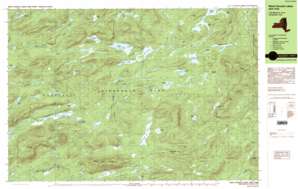
Spruce Lake Topo Map New York
To zoom in, hover over the map of Spruce Lake
USGS Topo Quad 43074e5 - 1:25,000 scale
| Topo Map Name: | Spruce Lake |
| USGS Topo Quad ID: | 43074e5 |
| Print Size: | ca. 39" wide x 24" high |
| Southeast Coordinates: | 43.5° N latitude / 74.5° W longitude |
| Map Center Coordinates: | 43.5625° N latitude / 74.625° W longitude |
| U.S. State: | NY |
| Filename: | k43074e5.jpg |
| Download Map JPG Image: | Spruce Lake topo map 1:25,000 scale |
| Map Type: | Topographic |
| Topo Series: | 7.5´x15´ |
| Map Scale: | 1:25,000 |
| Source of Map Images: | United States Geological Survey (USGS) |
| Alternate Map Versions: |
West Canada Lakes NY 1990 Download PDF Buy paper map West Canada Lakes NY 1990, updated 1990 Download PDF Buy paper map West Canada Lakes NY 1997, updated 1999 Download PDF Buy paper map |
1:24,000 Topo Quads surrounding Spruce Lake
> Back to 43074e1 at 1:100,000 scale
> Back to 43074a1 at 1:250,000 scale
> Back to U.S. Topo Maps home
Spruce Lake topo map: Gazetteer
Spruce Lake: Bays
Noisey Inlet elevation 745m 2444′Pillsbury Bay elevation 744m 2440′
Spruce Lake: Dams
Mitchell Dam elevation 651m 2135′Spruce Lake: Lakes
Amos Lake elevation 697m 2286′Balsam Lake elevation 733m 2404′
Beaver Pond elevation 673m 2208′
Brooktrout Lake elevation 724m 2375′
Bullhead Pond elevation 758m 2486′
Cat Lake elevation 724m 2375′
Cedar Lakes elevation 744m 2440′
Deep Lake elevation 796m 2611′
Dewitt Pond elevation 728m 2388′
Goose Lake elevation 727m 2385′
Kings Pond elevation 760m 2493′
Little Moose Pond elevation 695m 2280′
Mica Lakes elevation 729m 2391′
Mud Lake elevation 714m 2342′
Muskrat Pond elevation 676m 2217′
Northrup Lake elevation 772m 2532′
Otter Lake elevation 705m 2312′
Otter Lake elevation 689m 2260′
Pillsbury Lake elevation 760m 2493′
Poor Lake elevation 730m 2395′
Puddle Hole elevation 765m 2509′
Sampson Lake elevation 729m 2391′
South Lake elevation 718m 2355′
Spruce Lake elevation 725m 2378′
Twin Lakes elevation 813m 2667′
West Canada Lakes elevation 718m 2355′
West Lake elevation 725m 2378′
Whitney Lake elevation 752m 2467′
Spruce Lake: Reservoirs
Second Stillwater elevation 651m 2135′Spruce Lake: Ridges
Blue Ridge elevation 884m 2900′Noisey Ridge elevation 874m 2867′
Spruce Lake: Streams
Big Brook elevation 553m 1814′Bloodgood Brook elevation 605m 1984′
Mud Creek elevation 717m 2352′
Stony Brook elevation 728m 2388′
Whitney Creek elevation 718m 2355′
Wolf Creek elevation 687m 2253′
Spruce Lake: Summits
Cobble Hill elevation 826m 2709′Goodluck Mountain elevation 822m 2696′
Pillsbury Mountain elevation 1094m 3589′
Spruce Lake Mountain elevation 964m 3162′
West Canada Mountain elevation 912m 2992′
Willis Mountain elevation 750m 2460′
Spruce Lake: Swamps
Belden Vly elevation 688m 2257′Carter Mudhole elevation 685m 2247′
Sampson Bog elevation 728m 2388′
Spruce Lake digital topo map on disk
Buy this Spruce Lake topo map showing relief, roads, GPS coordinates and other geographical features, as a high-resolution digital map file on DVD:
New York, Vermont, Connecticut & Western Massachusetts
Buy digital topo maps: New York, Vermont, Connecticut & Western Massachusetts


