Gore Mountain Topo Map New York
To zoom in, hover over the map of Gore Mountain
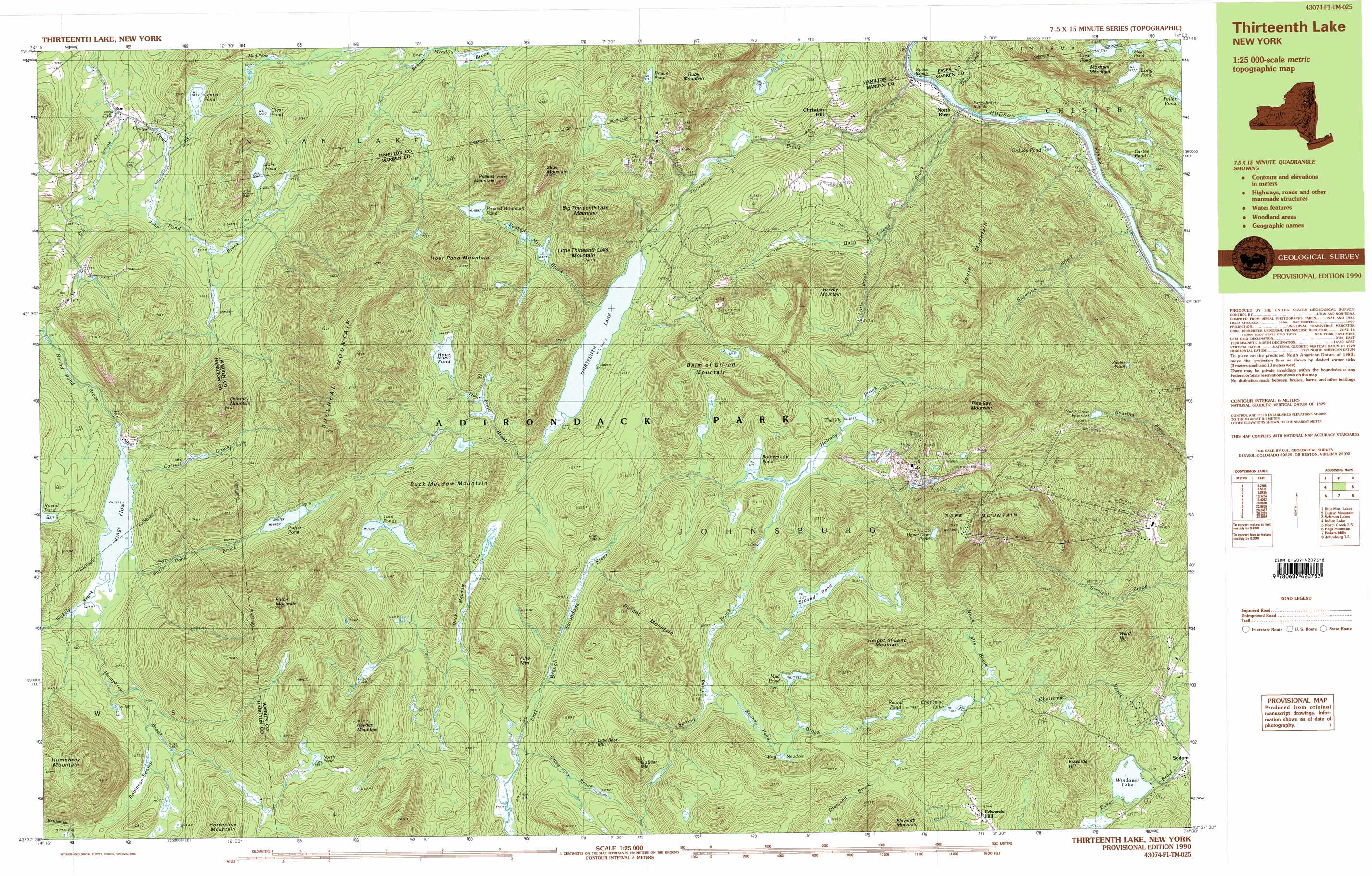
USGS Topo Quad 43074f1 - 1:25,000 scale
| Topo Map Name: | Gore Mountain |
| USGS Topo Quad ID: | 43074f1 |
| Print Size: | ca. 39" wide x 24" high |
| Southeast Coordinates: | 43.625° N latitude / 74° W longitude |
| Map Center Coordinates: | 43.6875° N latitude / 74.125° W longitude |
| U.S. State: | NY |
| Filename: | k43074f1.jpg |
| Download Map JPG Image: | Gore Mountain topo map 1:25,000 scale |
| Map Type: | Topographic |
| Topo Series: | 7.5´x15´ |
| Map Scale: | 1:25,000 |
| Source of Map Images: | United States Geological Survey (USGS) |
| Alternate Map Versions: |
Thirteenth Lake NY 1990, updated 1990 Download PDF Buy paper map Thirteenth Lake NY 1990, updated 1990 Download PDF Buy paper map Thirteenth Lake NY 1997, updated 1999 Download PDF Buy paper map Thirteenth Lake NY 1997, updated 2000 Download PDF Buy paper map |
1:24,000 Topo Quads surrounding Gore Mountain
Dunbrook Mountain |
Vanderwhacker Mountain |
Blue Ridge |
||
Burgess Mountain |
Starbuck Mountain |
Schroon Lake |
||
Sabael |
Gore Mountain |
North Creek |
Chestertown |
|
Kunjamuk River |
Bakers Mills |
Johnsburg |
The Glen |
|
Wells |
Harrisburg |
Stony Creek |
Warrensburg |
> Back to 43074e1 at 1:100,000 scale
> Back to 43074a1 at 1:250,000 scale
> Back to U.S. Topo Maps home
Gore Mountain topo map: Gazetteer
Gore Mountain: Flats
Bog Meadow elevation 663m 2175′Gore Mountain: Lakes
Botheration Pond elevation 615m 2017′Brown Pond elevation 621m 2037′
Carter Pond elevation 382m 1253′
Center Pond elevation 525m 1722′
Chatiemac Lake elevation 697m 2286′
Clear Pond elevation 516m 1692′
Clear Pond elevation 580m 1902′
Hour Pond elevation 641m 2103′
John Pond elevation 556m 1824′
Kings Flow elevation 524m 1719′
Long Pond elevation 478m 1568′
Mud Pond elevation 718m 2355′
Mud Pond elevation 500m 1640′
North Pond elevation 688m 2257′
Ordway Pond elevation 326m 1069′
Peaked Mountain Pond elevation 684m 2244′
Puffer Pond elevation 665m 2181′
Rabbit Pond elevation 568m 1863′
Round Pond elevation 724m 2375′
Second Pond elevation 681m 2234′
The Vly elevation 618m 2027′
Thirteenth Lake elevation 510m 1673′
Twin Ponds elevation 641m 2103′
Upper Dam Pond elevation 920m 3018′
Windover Lake elevation 459m 1505′
Gore Mountain: Mines
Bartons Mine elevation 749m 2457′Gore Mountain: Populated Places
Christian Hill elevation 453m 1486′Edwards Hill elevation 574m 1883′
North River elevation 327m 1072′
Gore Mountain: Rapids
Mouse Rapids elevation 319m 1046′Perry Ehlers Rapids elevation 313m 1026′
Gore Mountain: Reservoirs
North Creek Reservoir elevation 632m 2073′Gore Mountain: Streams
Balm of Gilead Brook elevation 324m 1062′Black Mountain Brook elevation 682m 2237′
Carroll Brook elevation 524m 1719′
Center Pond Brook elevation 498m 1633′
Chatiemac Brook elevation 419m 1374′
Cross Brook elevation 504m 1653′
Deer Creek elevation 318m 1043′
Halfway Brook elevation 616m 2020′
Hour Pond Brook elevation 519m 1702′
Humphrey Brook elevation 524m 1719′
John Pond Brook elevation 509m 1669′
Little Brook elevation 443m 1453′
Peaked Mountain Brook elevation 513m 1683′
Puffer Pond Brook elevation 524m 1719′
Raymond Brook elevation 307m 1007′
Round Pond Brook elevation 615m 2017′
Second Pond Brook elevation 508m 1666′
Thirteenth Brook elevation 319m 1046′
Wakely Brook elevation 524m 1719′
Gore Mountain: Summits
Balm of Gilead Mountain elevation 736m 2414′Big Bear Mountain elevation 721m 2365′
Big Thirteenth Lake Mountain elevation 829m 2719′
Buck Meadow Mountain elevation 782m 2565′
Bullhead Mountain elevation 1011m 3316′
Chimney Mountain elevation 805m 2641′
Durant Mountain elevation 728m 2388′
Edwards Hill elevation 661m 2168′
Gore Mountain elevation 975m 3198′
Harvey Mountain elevation 678m 2224′
Hayden Mountain elevation 842m 2762′
Height of Land Mountain elevation 898m 2946′
Hour Pond Mountain elevation 868m 2847′
Humphrey Mountain elevation 907m 2975′
Little Bear Mountain elevation 669m 2194′
Little Thirteenth Lake Mountain elevation 761m 2496′
Peaked Mountain elevation 882m 2893′
Pete Gay Mountain elevation 944m 3097′
Pine Mountain elevation 679m 2227′
Puffer Mountain elevation 1048m 3438′
Ruby Mountain elevation 805m 2641′
Slide Mountain elevation 873m 2864′
South Mountain elevation 736m 2414′
Ward Hill elevation 673m 2208′
Gore Mountain: Swamps
Buck Meadow Flow elevation 543m 1781′Mud Pond elevation 561m 1840′
Robinson Swamp elevation 591m 1938′
Gore Mountain digital topo map on disk
Buy this Gore Mountain topo map showing relief, roads, GPS coordinates and other geographical features, as a high-resolution digital map file on DVD:
New York, Vermont, Connecticut & Western Massachusetts
Buy digital topo maps: New York, Vermont, Connecticut & Western Massachusetts