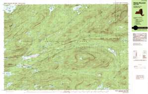
Wakely Mountain Topo Map New York
To zoom in, hover over the map of Wakely Mountain
USGS Topo Quad 43074f5 - 1:25,000 scale
| Topo Map Name: | Wakely Mountain |
| USGS Topo Quad ID: | 43074f5 |
| Print Size: | ca. 39" wide x 24" high |
| Southeast Coordinates: | 43.625° N latitude / 74.5° W longitude |
| Map Center Coordinates: | 43.6875° N latitude / 74.625° W longitude |
| U.S. State: | NY |
| Filename: | k43074f5.jpg |
| Download Map JPG Image: | Wakely Mountain topo map 1:25,000 scale |
| Map Type: | Topographic |
| Topo Series: | 7.5´x15´ |
| Map Scale: | 1:25,000 |
| Source of Map Images: | United States Geological Survey (USGS) |
| Alternate Map Versions: |
Wakely Mountain NY 1990, updated 1990 Download PDF Buy paper map Wakely Mountain NY 1990, updated 1990 Download PDF Buy paper map Wakely Mountain NY 1997, updated 2000 Download PDF Buy paper map |
1:24,000 Topo Quads surrounding Wakely Mountain
Nehasane Lake |
Forked Lake |
Dunbrook Mountain |
||
Eagle Bay |
Sargent Ponds |
Burgess Mountain |
||
Limekiln Lake |
Wakely Mountain |
Sabael |
||
Honnedaga Lake |
Spruce Lake |
Kunjamuk River |
||
Morehouseville |
Piseco Lake |
Wells |
> Back to 43074e1 at 1:100,000 scale
> Back to 43074a1 at 1:250,000 scale
> Back to U.S. Topo Maps home
Wakely Mountain topo map: Gazetteer
Wakely Mountain: Areas
Moose River Recreation Area elevation 583m 1912′Wakely Mountain: Flats
The Plains elevation 564m 1850′Wakely Mountain: Islands
Goff Island elevation 547m 1794′Wakely Mountain: Lakes
Bear Pond elevation 637m 2089′Beaver Lake elevation 559m 1833′
Beaver Pond elevation 744m 2440′
Cellar Pond elevation 907m 2975′
Falls Pond elevation 755m 2477′
Helldiver Pond elevation 566m 1856′
Home Pond elevation 645m 2116′
Icehouse Pond elevation 569m 1866′
Jimmy Pond elevation 845m 2772′
Little Moose Lake elevation 643m 2109′
Lost Pond elevation 717m 2352′
Lost Ponds elevation 584m 1916′
Mitchell Ponds elevation 585m 1919′
Mohegan Lake elevation 616m 2020′
Sly Pond elevation 877m 2877′
Squaw Lake elevation 646m 2119′
Wolf Lake elevation 789m 2588′
Wakely Mountain: Populated Places
Kenwells (historical) elevation 628m 2060′Wakely Mountain: Reservoirs
Lake Kora elevation 643m 2109′Wakely Mountain: Ridges
Lamphere Ridge elevation 686m 2250′Wilson Ridge elevation 843m 2765′
Wakely Mountain: Streams
Bear Paw Creek elevation 587m 1925′Benedict Creek elevation 562m 1843′
Bradley Brook elevation 636m 2086′
Buck Creek elevation 546m 1791′
Butter Brook elevation 624m 2047′
Cellar Brook elevation 675m 2214′
Falls Pond Outlet elevation 572m 1876′
Grassy Brook elevation 716m 2349′
Jimmy Creek elevation 648m 2125′
Otter Brook elevation 558m 1830′
Pine Grove Creek elevation 563m 1847′
Silver Run elevation 606m 1988′
Sumner Stream elevation 562m 1843′
Wakely Brook elevation 641m 2103′
Wheeler Creek elevation 560m 1837′
Wakely Mountain: Summits
Bradley Mountain elevation 957m 3139′Cellar Mountain elevation 1038m 3405′
Kitty Cobble elevation 983m 3225′
Little Moose Mountain elevation 1100m 3608′
Manbury Mountain elevation 1053m 3454′
Mitchell Ponds Mountain elevation 753m 2470′
Mount Tom elevation 795m 2608′
Round Mountain elevation 844m 2769′
Seventh Lake Mountain elevation 883m 2896′
Wakely Mountain elevation 1143m 3750′
Wakely Mountain digital topo map on disk
Buy this Wakely Mountain topo map showing relief, roads, GPS coordinates and other geographical features, as a high-resolution digital map file on DVD:
New York, Vermont, Connecticut & Western Massachusetts
Buy digital topo maps: New York, Vermont, Connecticut & Western Massachusetts


