Limekiln Lake Topo Map New York
To zoom in, hover over the map of Limekiln Lake
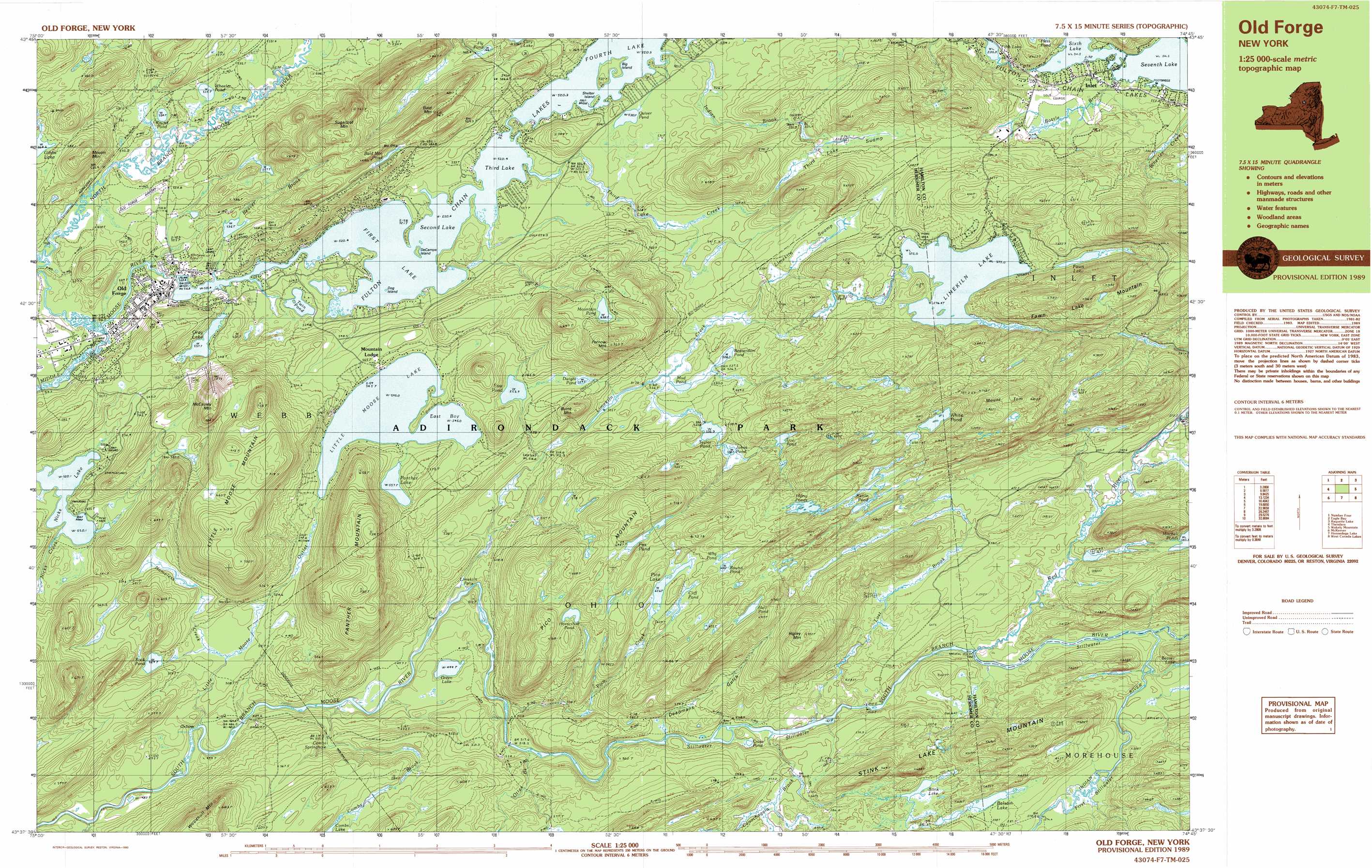
USGS Topo Quad 43074f7 - 1:25,000 scale
| Topo Map Name: | Limekiln Lake |
| USGS Topo Quad ID: | 43074f7 |
| Print Size: | ca. 39" wide x 24" high |
| Southeast Coordinates: | 43.625° N latitude / 74.75° W longitude |
| Map Center Coordinates: | 43.6875° N latitude / 74.875° W longitude |
| U.S. State: | NY |
| Filename: | k43074f7.jpg |
| Download Map JPG Image: | Limekiln Lake topo map 1:25,000 scale |
| Map Type: | Topographic |
| Topo Series: | 7.5´x15´ |
| Map Scale: | 1:25,000 |
| Source of Map Images: | United States Geological Survey (USGS) |
| Alternate Map Versions: |
Old Forge NY 1989, updated 1990 Download PDF Buy paper map |
1:24,000 Topo Quads surrounding Limekiln Lake
Stillwater Reservoir West |
Nehasane Lake |
Forked Lake |
||
Stillwater Mountain |
Eagle Bay |
Sargent Ponds |
||
Thendara |
Limekiln Lake |
Wakely Mountain |
||
Otter Lake |
Honnedaga Lake |
Spruce Lake |
||
North Wilmurt |
Morehouseville |
Piseco Lake |
> Back to 43074e1 at 1:100,000 scale
> Back to 43074a1 at 1:250,000 scale
> Back to U.S. Topo Maps home
Limekiln Lake topo map: Gazetteer
Limekiln Lake: Airports
Old Forge Airport elevation 532m 1745′Limekiln Lake: Bays
East Bay elevation 545m 1788′Limekiln Lake: Bends
Combs Springhole elevation 519m 1702′Limekiln Lake: Falls
Limekiln Falls elevation 482m 1581′Limekiln Lake: Islands
Big Island elevation 520m 1706′DeCamps Island elevation 520m 1706′
Dog Island elevation 520m 1706′
Shelter Island elevation 520m 1706′
Limekiln Lake: Lakes
Bald Mountain Pond elevation 608m 1994′Balsam Lake elevation 596m 1955′
Beaverdam Pond elevation 527m 1729′
Cliff Pond elevation 624m 2047′
Cross Pond elevation 538m 1765′
Doe Pond elevation 557m 1827′
Dwight Pond elevation 559m 1833′
East Pond elevation 554m 1817′
Fawn Lake elevation 596m 1955′
Fifth Lake elevation 520m 1706′
First Lake elevation 520m 1706′
First Stillwater elevation 570m 1870′
Fly Pond elevation 567m 1860′
Fourth Lake elevation 520m 1706′
Fox Pond elevation 642m 2106′
Fulton Chain Lakes elevation 520m 1706′
Gray Lake elevation 537m 1761′
Green Lake elevation 494m 1620′
Hall Pond elevation 699m 2293′
Harry Ponds elevation 652m 2139′
Horseshoe Pond elevation 634m 2080′
Johns Pond elevation 538m 1765′
Kettle Pond elevation 649m 2129′
Limekiln Lake elevation 575m 1886′
Little Moose Lake elevation 545m 1788′
Mountain Pond elevation 641m 2103′
Mud Pond elevation 525m 1722′
Nicks Lake elevation 520m 1706′
Panther Lake elevation 557m 1827′
Pico Lake elevation 627m 2057′
Quiver Pond elevation 530m 1738′
Rock Pond elevation 529m 1735′
Round Pond elevation 524m 1719′
Round Pond elevation 633m 2076′
Second Lake elevation 520m 1706′
Seventh Lake elevation 544m 1784′
Sixth Lake elevation 544m 1784′
Stink Lake elevation 591m 1938′
Taylor Pond elevation 532m 1745′
Third Lake elevation 520m 1706′
Twin Pond elevation 521m 1709′
Wheeler Pond elevation 525m 1722′
White Pond elevation 682m 2237′
Why Pond elevation 634m 2080′
Limekiln Lake: Populated Places
Mountain Lodge elevation 562m 1843′Old Forge elevation 529m 1735′
Limekiln Lake: Streams
Beaver Brook elevation 520m 1706′Bottle Brook elevation 546m 1791′
Canachagala Brook elevation 538m 1765′
Combs Brook elevation 488m 1601′
Indian Brook elevation 522m 1712′
Indian River elevation 552m 1811′
Limekiln Creek elevation 491m 1610′
Little Moose Outlet elevation 485m 1591′
Lost Brook elevation 534m 1751′
Nameless Creek elevation 516m 1692′
Natural Hatchery Brook elevation 568m 1863′
North Branch Moose River elevation 516m 1692′
Otter Brook elevation 514m 1686′
Pico Creek elevation 497m 1630′
Red River elevation 546m 1791′
Third Lake Creek elevation 520m 1706′
Limekiln Lake: Summits
Bald Mountain elevation 705m 2312′Burnt Mountain elevation 599m 1965′
Fawn Lake Mountain elevation 711m 2332′
Fernow Mountain elevation 709m 2326′
Higley Mountain elevation 743m 2437′
Little Moose Mountain elevation 716m 2349′
McCauley Mountain elevation 695m 2280′
Moulin Mountain elevation 645m 2116′
Mount Tom elevation 804m 2637′
Panther Mountain elevation 734m 2408′
Pico Mountain elevation 673m 2208′
Stink Lake Mountain elevation 686m 2250′
Sugarloaf Mountain elevation 690m 2263′
Limekiln Lake: Swamps
Limekiln Swamp elevation 558m 1830′Third Lake Swamp elevation 555m 1820′
Limekiln Lake: Valleys
Deadmans Gulch elevation 538m 1765′Limekiln Lake digital topo map on disk
Buy this Limekiln Lake topo map showing relief, roads, GPS coordinates and other geographical features, as a high-resolution digital map file on DVD:
New York, Vermont, Connecticut & Western Massachusetts
Buy digital topo maps: New York, Vermont, Connecticut & Western Massachusetts