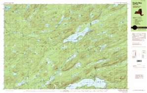
Eagle Bay Topo Map New York
To zoom in, hover over the map of Eagle Bay
USGS Topo Quad 43074g7 - 1:25,000 scale
| Topo Map Name: | Eagle Bay |
| USGS Topo Quad ID: | 43074g7 |
| Print Size: | ca. 39" wide x 24" high |
| Southeast Coordinates: | 43.75° N latitude / 74.75° W longitude |
| Map Center Coordinates: | 43.8125° N latitude / 74.875° W longitude |
| U.S. State: | NY |
| Filename: | k43074g7.jpg |
| Download Map JPG Image: | Eagle Bay topo map 1:25,000 scale |
| Map Type: | Topographic |
| Topo Series: | 7.5´x15´ |
| Map Scale: | 1:25,000 |
| Source of Map Images: | United States Geological Survey (USGS) |
| Alternate Map Versions: |
Eagle Bay NY 1989, updated 1989 Download PDF Buy paper map Eagle Bay NY 1989, updated 1989 Download PDF Buy paper map |
1:24,000 Topo Quads surrounding Eagle Bay
> Back to 43074e1 at 1:100,000 scale
> Back to 43074a1 at 1:250,000 scale
> Back to U.S. Topo Maps home
Eagle Bay topo map: Gazetteer
Eagle Bay: Bays
East Bay elevation 556m 1824′North Bay elevation 556m 1824′
South Bay elevation 556m 1824′
Eagle Bay: Capes
Craig Point elevation 556m 1824′Eagle Point elevation 522m 1712′
Gull Rock Point elevation 522m 1712′
Rock Point elevation 520m 1706′
Eagle Bay: Islands
Bartons Island elevation 520m 1706′Cedar Island elevation 522m 1712′
Dollar Island elevation 520m 1706′
Melody Island elevation 512m 1679′
Thistle Island elevation 522m 1712′
Eagle Bay: Lakes
Big Chief Pond elevation 598m 1961′Big Diamond Pond elevation 615m 2017′
Big Moose Lake elevation 556m 1824′
Bubb Lake elevation 553m 1814′
Buck Pond elevation 617m 2024′
Cary Lake elevation 554m 1817′
Cascade Lake elevation 556m 1824′
Chain Ponds elevation 633m 2076′
Chub Lake elevation 603m 1978′
Clear Pond elevation 533m 1748′
Constable Pond elevation 581m 1906′
Cranberry Pond elevation 589m 1932′
Dart Lake elevation 537m 1761′
Doe Pond elevation 597m 1958′
East Pond elevation 656m 2152′
Goose Pond elevation 543m 1781′
Gull Lakes elevation 606m 1988′
Hess Pond elevation 562m 1843′
Independence Lake elevation 591m 1938′
Jock Pond elevation 650m 2132′
Lake Kan-ac-to elevation 531m 1742′
Lake Rondaxe elevation 524m 1719′
Lake Te-jec-na elevation 531m 1742′
Lilypad Ponds elevation 631m 2070′
Little Birch Pond elevation 630m 2066′
Little Chief Pond elevation 562m 1843′
Little Diamond Pond elevation 609m 1998′
Little Independence Pond elevation 590m 1935′
Little Rock Pond elevation 586m 1922′
Little Safford Lake elevation 530m 1738′
Lost Pond elevation 561m 1840′
Mays Pond elevation 579m 1899′
Merriam Lake elevation 658m 2158′
Moss Lake elevation 536m 1758′
Mountain Pond elevation 611m 2004′
Oswego Pond elevation 656m 2152′
Pigeon Lake elevation 633m 2076′
Pocket Ponds elevation 675m 2214′
Queer Lake elevation 597m 1958′
Razorback Pond elevation 675m 2214′
Russian Lake elevation 566m 1856′
Safford Pond elevation 539m 1768′
Silver Dollar Pond elevation 694m 2276′
Silver Lake elevation 643m 2109′
Sis Lake elevation 556m 1824′
Snake Pond elevation 589m 1932′
South Pond elevation 625m 2050′
Squash Pond elevation 654m 2145′
Surprise Pond elevation 527m 1729′
Thirsty Pond elevation 650m 2132′
Townsend Pond elevation 568m 1863′
Twitchell Lake elevation 625m 2050′
West Lake elevation 529m 1735′
West Pond elevation 581m 1906′
Windfall Pond elevation 592m 1942′
Woods Lake elevation 605m 1984′
Eagle Bay: Pillars
Browns Rock elevation 716m 2349′Eagle Bay: Populated Places
Big Moose elevation 626m 2053′Eagle Bay elevation 542m 1778′
Inlet elevation 533m 1748′
Woods Lake elevation 572m 1876′
Eagle Bay: Streams
Andys Creek elevation 603m 1978′Bald Mountain Brook elevation 524m 1719′
Birch Creek elevation 555m 1820′
Constable Creek elevation 559m 1833′
Eagle Creek elevation 522m 1712′
Fly Pond Outlet elevation 543m 1781′
Shaw Creek elevation 576m 1889′
Twitchell Creek elevation 523m 1715′
Eagle Bay: Summits
Black Bear Mountain elevation 748m 2454′Bottle Mountain elevation 723m 2372′
Cascade Mountain elevation 695m 2280′
Mount Tom elevation 745m 2444′
Rocky Mountain elevation 651m 2135′
Slide Off Mountain elevation 676m 2217′
Sugarloaf elevation 671m 2201′
Twitchell Mountain elevation 717m 2352′
Eagle Bay: Swamps
Lyons Marsh elevation 621m 2037′Eagle Bay digital topo map on disk
Buy this Eagle Bay topo map showing relief, roads, GPS coordinates and other geographical features, as a high-resolution digital map file on DVD:
New York, Vermont, Connecticut & Western Massachusetts
Buy digital topo maps: New York, Vermont, Connecticut & Western Massachusetts


