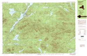
Dunbrook Mountain Topo Map New York
To zoom in, hover over the map of Dunbrook Mountain
USGS Topo Quad 43074h3 - 1:25,000 scale
| Topo Map Name: | Dunbrook Mountain |
| USGS Topo Quad ID: | 43074h3 |
| Print Size: | ca. 39" wide x 24" high |
| Southeast Coordinates: | 43.875° N latitude / 74.25° W longitude |
| Map Center Coordinates: | 43.9375° N latitude / 74.375° W longitude |
| U.S. State: | NY |
| Filename: | k43074h3.jpg |
| Download Map JPG Image: | Dunbrook Mountain topo map 1:25,000 scale |
| Map Type: | Topographic |
| Topo Series: | 7.5´x15´ |
| Map Scale: | 1:25,000 |
| Source of Map Images: | United States Geological Survey (USGS) |
| Alternate Map Versions: |
Deerland NY 1989, updated 1989 Download PDF Buy paper map Deerland NY 1997, updated 1999 Download PDF Buy paper map |
1:24,000 Topo Quads surrounding Dunbrook Mountain
> Back to 43074e1 at 1:100,000 scale
> Back to 43074a1 at 1:250,000 scale
> Back to U.S. Topo Maps home
Dunbrook Mountain topo map: Gazetteer
Dunbrook Mountain: Airports
Long Lake-Helms Seaplane Base elevation 497m 1630′Long Lake-Sagamore Marina and Seaplane Base elevation 505m 1656′
Dunbrook Mountain: Bays
Kellers Bay elevation 497m 1630′Dunbrook Mountain: Capes
Oven Point elevation 498m 1633′Dunbrook Mountain: Falls
Buttermilk Falls elevation 504m 1653′Dunbrook Mountain: Islands
Moose Island elevation 497m 1630′Pine Island elevation 497m 1630′
Dunbrook Mountain: Lakes
Chub Pond elevation 587m 1925′County Line Flow elevation 507m 1663′
Deer Pond elevation 494m 1620′
Essex Chain Lakes elevation 488m 1601′
Helms Pond elevation 644m 2112′
Lake Eaton elevation 523m 1715′
Lilypad Pond elevation 487m 1597′
Long Pond elevation 487m 1597′
Minnow Pond elevation 611m 2004′
Mud Pond elevation 488m 1601′
Mud Pond elevation 557m 1827′
Park Lake elevation 499m 1637′
Polliwog Pond elevation 526m 1725′
Salmon Pond elevation 631m 2070′
Shaw Pond elevation 530m 1738′
South Pond elevation 537m 1761′
Third Lake elevation 488m 1601′
Tirrel Pond elevation 585m 1919′
Wolf Pond elevation 722m 2368′
Dunbrook Mountain: Pillars
Castle Rock elevation 744m 2440′Dunbrook Mountain: Populated Places
Deerland elevation 507m 1663′Long Lake elevation 510m 1673′
Dunbrook Mountain: Reservoirs
Long Lake Reservoir elevation 598m 1961′Dunbrook Mountain: Ridges
Fishing Brook Range elevation 996m 3267′Dunbrook Mountain: Streams
Donnelly Brook elevation 524m 1719′East Inlet Brook elevation 537m 1761′
Mud Pond Outlet elevation 537m 1761′
Owls Head Pond Outlet elevation 497m 1630′
Roaring Brook elevation 632m 2073′
Salmon River elevation 546m 1791′
Sandy Creek elevation 531m 1742′
Shaw Brook elevation 502m 1646′
Sixmile Brook elevation 517m 1696′
South Pond Outlet elevation 497m 1630′
Stanley Brook elevation 525m 1722′
Dunbrook Mountain: Summits
Buck Mountain elevation 802m 2631′Burnt Mountain elevation 779m 2555′
Dun Brook Mountain elevation 1086m 3562′
East Inlet Mountain elevation 838m 2749′
Fishing Brook Mountain elevation 1082m 3549′
Little Blue Mountain elevation 852m 2795′
Mount Sabattis elevation 866m 2841′
Owls Head Mountain elevation 849m 2785′
Peaked Mountain elevation 787m 2582′
Sugarloaf Mountain elevation 687m 2253′
The Pinnacle elevation 658m 2158′
Tirrell Mountain elevation 900m 2952′
Tongue Mountain elevation 963m 3159′
Triplet Hill elevation 590m 1935′
Windfall Mountain elevation 829m 2719′
Dunbrook Mountain digital topo map on disk
Buy this Dunbrook Mountain topo map showing relief, roads, GPS coordinates and other geographical features, as a high-resolution digital map file on DVD:
New York, Vermont, Connecticut & Western Massachusetts
Buy digital topo maps: New York, Vermont, Connecticut & Western Massachusetts


