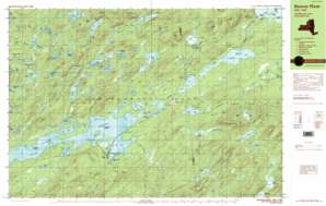
Nehasane Lake Topo Map New York
To zoom in, hover over the map of Nehasane Lake
USGS Topo Quad 43074h7 - 1:25,000 scale
| Topo Map Name: | Nehasane Lake |
| USGS Topo Quad ID: | 43074h7 |
| Print Size: | ca. 39" wide x 24" high |
| Southeast Coordinates: | 43.875° N latitude / 74.75° W longitude |
| Map Center Coordinates: | 43.9375° N latitude / 74.875° W longitude |
| U.S. State: | NY |
| Filename: | k43074h7.jpg |
| Download Map JPG Image: | Nehasane Lake topo map 1:25,000 scale |
| Map Type: | Topographic |
| Topo Series: | 7.5´x15´ |
| Map Scale: | 1:25,000 |
| Source of Map Images: | United States Geological Survey (USGS) |
| Alternate Map Versions: |
Beavers River NY 1989, updated 1989 Download PDF Buy paper map Beavers River NY 1989, updated 1989 Download PDF Buy paper map |
1:24,000 Topo Quads surrounding Nehasane Lake
> Back to 43074e1 at 1:100,000 scale
> Back to 43074a1 at 1:250,000 scale
> Back to U.S. Topo Maps home
Nehasane Lake topo map: Gazetteer
Nehasane Lake: Bays
Gun Harbor elevation 512m 1679′Nehasane Lake: Capes
Wigwam Point elevation 527m 1729′Nehasane Lake: Islands
Buck Island elevation 528m 1732′Mosquito Island elevation 523m 1715′
Nehasane Lake: Lakes
Bear Pond elevation 625m 2050′Beaverdam Pond elevation 535m 1755′
Big Burnt Lake elevation 512m 1679′
Buck Pond elevation 561m 1840′
Clear Lake elevation 613m 2011′
Covey Pond elevation 682m 2237′
Crooked Lake elevation 624m 2047′
Deer Pond elevation 607m 1991′
Dismal Pond elevation 624m 2047′
Elbow Pond elevation 545m 1788′
Elbow Pond elevation 545m 1788′
Falls Lake elevation 514m 1686′
Hawk Pond elevation 646m 2119′
Hidden Lake elevation 545m 1788′
Higby Twin Ponds elevation 586m 1922′
Huckleberry Pond elevation 626m 2053′
Little Lilly Pad Pond elevation 596m 1955′
Little Rock Pond elevation 542m 1778′
Loon Lake elevation 512m 1679′
Lost Island Pond elevation 550m 1804′
Lower Beech Ridge Pond elevation 630m 2066′
Lower Sister Lake elevation 590m 1935′
Mud Lake elevation 535m 1755′
Mud Pond elevation 613m 2011′
Negro Lake elevation 563m 1847′
Nehasane Lake elevation 516m 1692′
Norridgewock Lake elevation 512m 1679′
Rock Lake elevation 546m 1791′
Rose Pond elevation 546m 1791′
Salmon Lake elevation 524m 1719′
Shingle Shanty Pond elevation 579m 1899′
Sitz Pond elevation 592m 1942′
Summit Pond elevation 630m 2066′
Terror Lake elevation 619m 2030′
Thayer Lake elevation 544m 1784′
Trout Pond elevation 512m 1679′
Upper Beech Ridge Pond elevation 637m 2089′
Upper Sister Lake elevation 590m 1935′
Walker Lake elevation 638m 2093′
Wilder Pond elevation 590m 1935′
Willys Lake elevation 632m 2073′
Witchhopple Lake elevation 536m 1758′
Nehasane Lake: Populated Places
Beaver River elevation 516m 1692′Brandreth elevation 518m 1699′
Keepawa elevation 523m 1715′
Little Rapids elevation 516m 1692′
Partlow elevation 534m 1751′
Nehasane Lake: Streams
Alder Creek elevation 519m 1702′Gun Harbor Brook elevation 515m 1689′
North Branch elevation 514m 1686′
North Branch Shingle Shanty Brook elevation 531m 1742′
South Branch elevation 518m 1699′
West Branch Beaver River elevation 513m 1683′
Nehasane Lake: Summits
Albany Mountain elevation 705m 2312′Home Hill elevation 622m 2040′
Mount Electra elevation 689m 2260′
Mount Frederick elevation 686m 2250′
Summit Mountain elevation 719m 2358′
Nehasane Lake: Trails
Norridge Trail elevation 642m 2106′Salmon Lake Trail elevation 534m 1751′
Nehasane Lake digital topo map on disk
Buy this Nehasane Lake topo map showing relief, roads, GPS coordinates and other geographical features, as a high-resolution digital map file on DVD:
New York, Vermont, Connecticut & Western Massachusetts
Buy digital topo maps: New York, Vermont, Connecticut & Western Massachusetts


