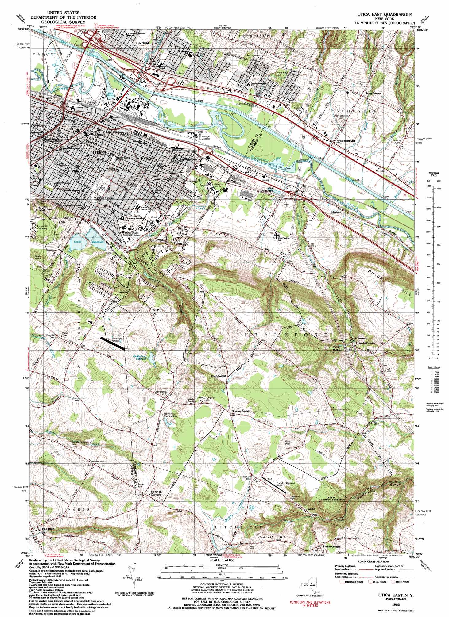
Utica East Topo Map New York
To zoom in, hover over the map of Utica East
USGS Topo Quad 43075a2 - 1:24,000 scale
| Topo Map Name: | Utica East |
| USGS Topo Quad ID: | 43075a2 |
| Print Size: | ca. 21 1/4" wide x 27" high |
| Southeast Coordinates: | 43° N latitude / 75.125° W longitude |
| Map Center Coordinates: | 43.0625° N latitude / 75.1875° W longitude |
| U.S. State: | NY |
| Filename: | o43075a2.jpg |
| Download Map JPG Image: | Utica East topo map 1:24,000 scale |
| Map Type: | Topographic |
| Topo Series: | 7.5´ |
| Map Scale: | 1:24,000 |
| Source of Map Images: | United States Geological Survey (USGS) |
| Alternate Map Versions: |
Utica East NY 1943, updated 1953 Download PDF Buy paper map Utica East NY 1955, updated 1957 Download PDF Buy paper map Utica East NY 1955, updated 1965 Download PDF Buy paper map Utica East NY 1983, updated 1983 Download PDF Buy paper map Utica East NY 2011 Download PDF Buy paper map Utica East NY 2013 Download PDF Buy paper map Utica East NY 2016 Download PDF Buy paper map |
1:24,000 Topo Quads surrounding Utica East
Westernville |
North Western |
Remsen |
Hinckley |
|
Rome |
Oriskany |
South Trenton |
Newport |
Middleville |
Clinton |
Utica West |
Utica East |
Ilion |
Herkimer |
Oriskany Falls |
Cassville |
West Winfield |
Millers Mills |
Jordanville |
Hubbardsville |
Brookfield |
Unadilla Forks |
Schuyler Lake |
Richfield Springs |
> Back to 43075a1 at 1:100,000 scale
> Back to 43074a1 at 1:250,000 scale
> Back to U.S. Topo Maps home
Utica East topo map: Gazetteer
Utica East: Airports
Frankfort-Highland Airport elevation 408m 1338′Smithport Airport elevation 341m 1118′
Utica East: Crossings
Interchange 31 elevation 127m 416′Utica East: Harbors
Utica Canal Terminal Harbor elevation 120m 393′Utica East: Parks
Edward J Hirt Playground elevation 136m 446′Fort Schuyler Park elevation 129m 423′
Harry V Quinn Playground elevation 152m 498′
Johnson Park elevation 159m 521′
Kernan Park elevation 159m 521′
North Utica Park elevation 152m 498′
Proctor Park elevation 156m 511′
Richard P Conner Park elevation 164m 538′
Roscoe Conkling Park elevation 229m 751′
Steuben Park elevation 153m 501′
Watson Williams Park elevation 165m 541′
Utica East: Populated Places
Baker Corners elevation 171m 561′Deerfield elevation 135m 442′
Frankfort Center elevation 210m 688′
Gulph elevation 340m 1115′
Harbor elevation 128m 419′
Heritage Acres elevation 139m 456′
K And B Mobile Home Park elevation 272m 892′
Norwich Corners elevation 394m 1292′
Stewart Corners elevation 409m 1341′
Utica elevation 139m 456′
West Frankfort elevation 128m 419′
West Schuyler elevation 129m 423′
Utica East: Post Offices
Captain George A Wood Post Office Building elevation 128m 419′Utica East: Reservoirs
Cascade Reservoir Number 5 elevation 186m 610′Golden Reservoir Number 4 elevation 197m 646′
Graffenburg Reservoir elevation 333m 1092′
Hopper Reservoir Number 2 elevation 183m 600′
South Reservoir elevation 183m 600′
Utica East: Streams
Ballou Creek elevation 121m 396′Black Creek elevation 387m 1269′
Budlong Creek elevation 123m 403′
Burch Creek elevation 117m 383′
Ferguson Creek elevation 117m 383′
Gridley Creek elevation 123m 403′
Knapp Brook elevation 117m 383′
Reall Creek elevation 123m 403′
Starch Factory Creek elevation 121m 396′
Wood Creek elevation 117m 383′
Utica East: Summits
Bennett Hill elevation 421m 1381′Dutch Hill elevation 318m 1043′
Pinnacle Hill elevation 398m 1305′
Utica East: Woods
South Woods elevation 232m 761′Utica East digital topo map on disk
Buy this Utica East topo map showing relief, roads, GPS coordinates and other geographical features, as a high-resolution digital map file on DVD:
New York, Vermont, Connecticut & Western Massachusetts
Buy digital topo maps: New York, Vermont, Connecticut & Western Massachusetts