Oneida Topo Map New York
To zoom in, hover over the map of Oneida
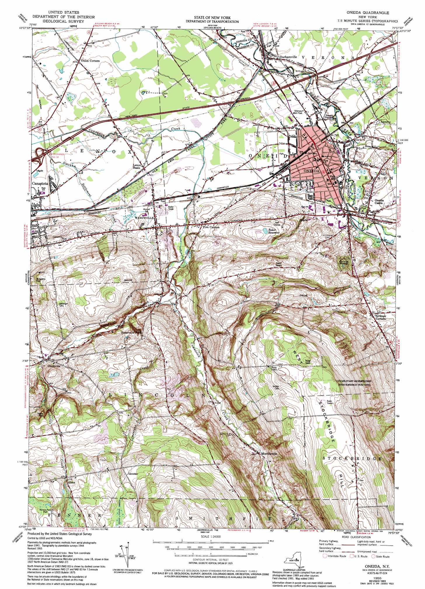
USGS Topo Quad 43075a6 - 1:24,000 scale
| Topo Map Name: | Oneida |
| USGS Topo Quad ID: | 43075a6 |
| Print Size: | ca. 21 1/4" wide x 27" high |
| Southeast Coordinates: | 43° N latitude / 75.625° W longitude |
| Map Center Coordinates: | 43.0625° N latitude / 75.6875° W longitude |
| U.S. State: | NY |
| Filename: | o43075a6.jpg |
| Download Map JPG Image: | Oneida topo map 1:24,000 scale |
| Map Type: | Topographic |
| Topo Series: | 7.5´ |
| Map Scale: | 1:24,000 |
| Source of Map Images: | United States Geological Survey (USGS) |
| Alternate Map Versions: |
Oneida NY 1947 Download PDF Buy paper map Oneida NY 1955, updated 1957 Download PDF Buy paper map Oneida NY 1955, updated 1957 Download PDF Buy paper map Oneida NY 1955, updated 1957 Download PDF Buy paper map Oneida NY 1955, updated 1994 Download PDF Buy paper map Oneida NY 2010 Download PDF Buy paper map Oneida NY 2013 Download PDF Buy paper map Oneida NY 2016 Download PDF Buy paper map |
1:24,000 Topo Quads surrounding Oneida
Panther Lake |
Camden West |
Camden East |
Lee Center |
Westernville |
Cleveland |
Jewell |
Sylvan Beach |
Verona |
Rome |
Manlius |
Canastota |
Oneida |
Vernon |
Clinton |
Oran |
Cazenovia |
Morrisville |
Munnsville |
Oriskany Falls |
De Ruyter |
Erieville |
West Eaton |
Hamilton |
Hubbardsville |
> Back to 43075a1 at 1:100,000 scale
> Back to 43074a1 at 1:250,000 scale
> Back to U.S. Topo Maps home
Oneida topo map: Gazetteer
Oneida: Airports
Oneida City Hospital Heliport elevation 168m 551′State Police Troop D Heliport elevation 130m 426′
Oneida: Falls
Buttermilk Falls elevation 213m 698′Oneida: Lakes
Baker Reservoir elevation 202m 662′Oneida: Parks
Allen Park elevation 138m 452′Holmes Park elevation 133m 436′
Lincoln Park elevation 135m 442′
Oneida: Populated Places
Alene elevation 375m 1230′Clockville elevation 210m 688′
Durhamville elevation 132m 433′
Five Corners elevation 158m 518′
Lenox elevation 161m 528′
Lenox Basin elevation 130m 426′
Merrillsville elevation 210m 688′
Oneida elevation 131m 429′
Oneida Castle elevation 137m 449′
Scribner Corners elevation 172m 564′
Wampsville elevation 147m 482′
Oneida: Streams
Clockville Creek elevation 158m 518′Dutch Settlement Creek elevation 121m 396′
Limestone Creek elevation 172m 564′
Sconondoa Creek elevation 128m 419′
Oneida: Summits
West Stockbridge Hill elevation 430m 1410′Oneida digital topo map on disk
Buy this Oneida topo map showing relief, roads, GPS coordinates and other geographical features, as a high-resolution digital map file on DVD:
New York, Vermont, Connecticut & Western Massachusetts
Buy digital topo maps: New York, Vermont, Connecticut & Western Massachusetts