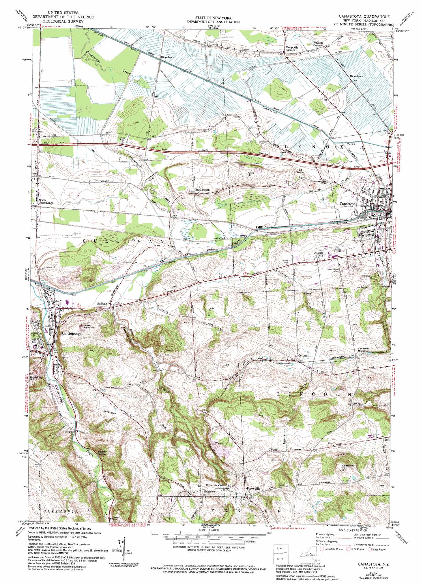
Canastota Topo Map New York
To zoom in, hover over the map of Canastota
USGS Topo Quad 43075a7 - 1:24,000 scale
| Topo Map Name: | Canastota |
| USGS Topo Quad ID: | 43075a7 |
| Print Size: | ca. 21 1/4" wide x 27" high |
| Southeast Coordinates: | 43° N latitude / 75.75° W longitude |
| Map Center Coordinates: | 43.0625° N latitude / 75.8125° W longitude |
| U.S. State: | NY |
| Filename: | o43075a7.jpg |
| Download Map JPG Image: | Canastota topo map 1:24,000 scale |
| Map Type: | Topographic |
| Topo Series: | 7.5´ |
| Map Scale: | 1:24,000 |
| Source of Map Images: | United States Geological Survey (USGS) |
| Alternate Map Versions: |
Canastota NY 1957, updated 1959 Download PDF Buy paper map Canastota NY 1957, updated 1969 Download PDF Buy paper map Canastota NY 1957, updated 1994 Download PDF Buy paper map Canastota NY 2010 Download PDF Buy paper map Canastota NY 2013 Download PDF Buy paper map Canastota NY 2016 Download PDF Buy paper map |
1:24,000 Topo Quads surrounding Canastota
Mallory |
Panther Lake |
Camden West |
Camden East |
Lee Center |
Cicero |
Cleveland |
Jewell |
Sylvan Beach |
Verona |
Syracuse East |
Manlius |
Canastota |
Oneida |
Vernon |
Jamesville |
Oran |
Cazenovia |
Morrisville |
Munnsville |
Tully |
De Ruyter |
Erieville |
West Eaton |
Hamilton |
> Back to 43075a1 at 1:100,000 scale
> Back to 43074a1 at 1:250,000 scale
> Back to U.S. Topo Maps home
Canastota topo map: Gazetteer
Canastota: Airports
Canastota Airport (historical) elevation 162m 531′Lakeview Airport elevation 317m 1040′
Luther Airport elevation 226m 741′
Canastota: Canals
Douglas Ditch elevation 113m 370′Canastota: Falls
Perryville Falls elevation 289m 948′Canastota: Populated Places
Blakeslee elevation 339m 1112′Canastota elevation 131m 429′
Chittenango elevation 138m 452′
Cottons elevation 229m 751′
East Boston elevation 138m 452′
North Chittenango elevation 126m 413′
Oniontown elevation 114m 374′
Perryville elevation 331m 1085′
Quality Hill elevation 165m 541′
Sullivan elevation 139m 456′
Sulphur Springs elevation 158m 518′
Walkers Corners elevation 122m 400′
Canastota: Reservoirs
Canastota Reservoir elevation 201m 659′Canastota: Streams
Canastota Creek elevation 117m 383′Owlville Creek elevation 117m 383′
Canastota: Summits
Allis Hill elevation 152m 498′Brinkerhoff Hill elevation 208m 682′
Cranson Hill elevation 455m 1492′
Lillies Pinnacle elevation 219m 718′
Canastota digital topo map on disk
Buy this Canastota topo map showing relief, roads, GPS coordinates and other geographical features, as a high-resolution digital map file on DVD:
New York, Vermont, Connecticut & Western Massachusetts
Buy digital topo maps: New York, Vermont, Connecticut & Western Massachusetts