Rome Topo Map New York
To zoom in, hover over the map of Rome
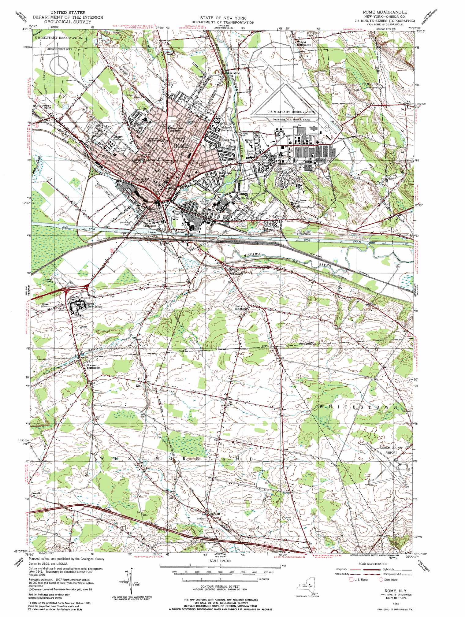
USGS Topo Quad 43075b4 - 1:24,000 scale
| Topo Map Name: | Rome |
| USGS Topo Quad ID: | 43075b4 |
| Print Size: | ca. 21 1/4" wide x 27" high |
| Southeast Coordinates: | 43.125° N latitude / 75.375° W longitude |
| Map Center Coordinates: | 43.1875° N latitude / 75.4375° W longitude |
| U.S. State: | NY |
| Filename: | o43075b4.jpg |
| Download Map JPG Image: | Rome topo map 1:24,000 scale |
| Map Type: | Topographic |
| Topo Series: | 7.5´ |
| Map Scale: | 1:24,000 |
| Source of Map Images: | United States Geological Survey (USGS) |
| Alternate Map Versions: |
Rome NY 1949 Download PDF Buy paper map Rome NY 1955, updated 1957 Download PDF Buy paper map Rome NY 1955, updated 1957 Download PDF Buy paper map Rome NY 1955, updated 1988 Download PDF Buy paper map Rome NY 1955, updated 1988 Download PDF Buy paper map Rome NY 2010 Download PDF Buy paper map Rome NY 2013 Download PDF Buy paper map Rome NY 2016 Download PDF Buy paper map |
1:24,000 Topo Quads surrounding Rome
Florence |
Point Rock |
West Leyden |
Boonville |
Forestport |
Camden East |
Lee Center |
Westernville |
North Western |
Remsen |
Sylvan Beach |
Verona |
Rome |
Oriskany |
South Trenton |
Oneida |
Vernon |
Clinton |
Utica West |
Utica East |
Morrisville |
Munnsville |
Oriskany Falls |
Cassville |
West Winfield |
> Back to 43075a1 at 1:100,000 scale
> Back to 43074a1 at 1:250,000 scale
> Back to U.S. Topo Maps home
Rome topo map: Gazetteer
Rome: Airports
Oneida County Airport elevation 217m 711′Stanwix Heights Airport elevation 186m 610′
Rome: Canals
Black River Canal elevation 146m 479′Old Erie Canal elevation 131m 429′
Rome City Hall elevation 139m 456′
Rome: Lakes
Throns Pond elevation 137m 449′Rome: Parks
Bell-Isle Park elevation 135m 442′East Park elevation 138m 452′
Fifth Ward Playground elevation 141m 462′
Fort Stanwix National Monument elevation 137m 449′
Fort Stanwix Park elevation 140m 459′
Franklyns Field elevation 143m 469′
Harr-Pinti Field elevation 135m 442′
Hazelton Park elevation 141m 462′
Riverside Park elevation 134m 439′
Vogel Park elevation 144m 472′
Rome: Populated Places
Air City elevation 144m 472′Bartlett elevation 165m 541′
Bloomfield Park elevation 140m 459′
Camelot Village elevation 181m 593′
Colonial Park elevation 141m 462′
Dix elevation 163m 534′
Liberty Gardens elevation 142m 465′
Lynch Tract elevation 143m 469′
Mohawk Gardens elevation 144m 472′
Ridge Mills elevation 154m 505′
Riverdale elevation 140m 459′
Rome elevation 139m 456′
Spencer Settlement elevation 159m 521′
Stanwix elevation 135m 442′
Stanwix Heights elevation 162m 531′
Tuxedo Mobile Home Park elevation 137m 449′
Wilbers Mobile Home Park elevation 177m 580′
Rome: Streams
Slate Creek elevation 133m 436′Wheelers Creek elevation 128m 419′
Rome digital topo map on disk
Buy this Rome topo map showing relief, roads, GPS coordinates and other geographical features, as a high-resolution digital map file on DVD:
New York, Vermont, Connecticut & Western Massachusetts
Buy digital topo maps: New York, Vermont, Connecticut & Western Massachusetts