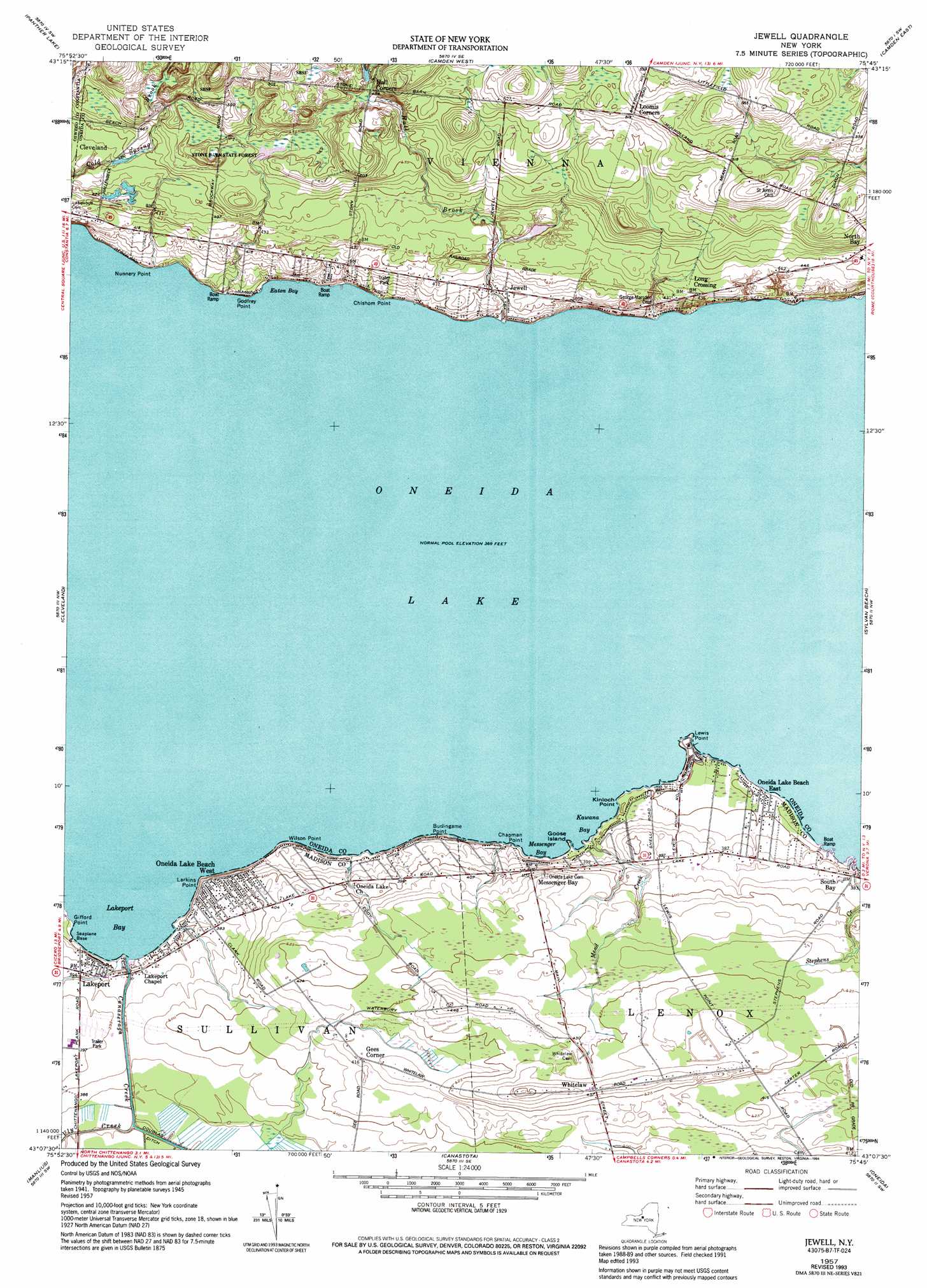
Jewell Topo Map New York
To zoom in, hover over the map of Jewell
USGS Topo Quad 43075b7 - 1:24,000 scale
| Topo Map Name: | Jewell |
| USGS Topo Quad ID: | 43075b7 |
| Print Size: | ca. 21 1/4" wide x 27" high |
| Southeast Coordinates: | 43.125° N latitude / 75.75° W longitude |
| Map Center Coordinates: | 43.1875° N latitude / 75.8125° W longitude |
| U.S. State: | NY |
| Filename: | o43075b7.jpg |
| Download Map JPG Image: | Jewell topo map 1:24,000 scale |
| Map Type: | Topographic |
| Topo Series: | 7.5´ |
| Map Scale: | 1:24,000 |
| Source of Map Images: | United States Geological Survey (USGS) |
| Alternate Map Versions: |
Jewell NY 1941 Download PDF Buy paper map Jewell NY 1957, updated 1959 Download PDF Buy paper map Jewell NY 1957, updated 1973 Download PDF Buy paper map Jewell NY 1957, updated 1994 Download PDF Buy paper map Jewell NY 2010 Download PDF Buy paper map Jewell NY 2013 Download PDF Buy paper map Jewell NY 2016 Download PDF Buy paper map |
1:24,000 Topo Quads surrounding Jewell
Dugway |
Williamstown |
Westdale |
Florence |
Point Rock |
Mallory |
Panther Lake |
Camden West |
Camden East |
Lee Center |
Cicero |
Cleveland |
Jewell |
Sylvan Beach |
Verona |
Syracuse East |
Manlius |
Canastota |
Oneida |
Vernon |
Jamesville |
Oran |
Cazenovia |
Morrisville |
Munnsville |
> Back to 43075a1 at 1:100,000 scale
> Back to 43074a1 at 1:250,000 scale
> Back to U.S. Topo Maps home
Jewell topo map: Gazetteer
Jewell: Bars
Lakeport Shoal elevation 112m 367′Messenger Shoal elevation 112m 367′
Jewell: Bays
Eaton Bay elevation 112m 367′Hughes Harbor elevation 112m 367′
Kawana Bay elevation 112m 367′
Lakeport Bay elevation 112m 367′
Messenger Bay elevation 112m 367′
Jewell: Capes
Burlingame Point elevation 117m 383′Chapman Point elevation 113m 370′
Chishom Point elevation 114m 374′
Gifford Point elevation 112m 367′
Godfrey Point elevation 115m 377′
Kinloch Point elevation 113m 370′
Larkins Point elevation 116m 380′
Lewis Point elevation 114m 374′
Nunnery Point elevation 116m 380′
Wilson Point elevation 115m 377′
Jewell: Islands
Goose Island elevation 112m 367′Jewell: Populated Places
Gees Corner elevation 127m 416′Jewell elevation 123m 403′
Lakeport elevation 120m 393′
Long Crossing elevation 132m 433′
Messenger Bay elevation 122m 400′
Oneida Lake Beach East elevation 113m 370′
Oneida Lake Beach West elevation 115m 377′
Whitelaw elevation 133m 436′
Jewell: Streams
Canaseraga Creek elevation 112m 367′Cowaselon Creek elevation 113m 370′
Hall Brook elevation 113m 370′
Mead Creek elevation 112m 367′
Vly Creek elevation 113m 370′
Jewell digital topo map on disk
Buy this Jewell topo map showing relief, roads, GPS coordinates and other geographical features, as a high-resolution digital map file on DVD:
New York, Vermont, Connecticut & Western Massachusetts
Buy digital topo maps: New York, Vermont, Connecticut & Western Massachusetts