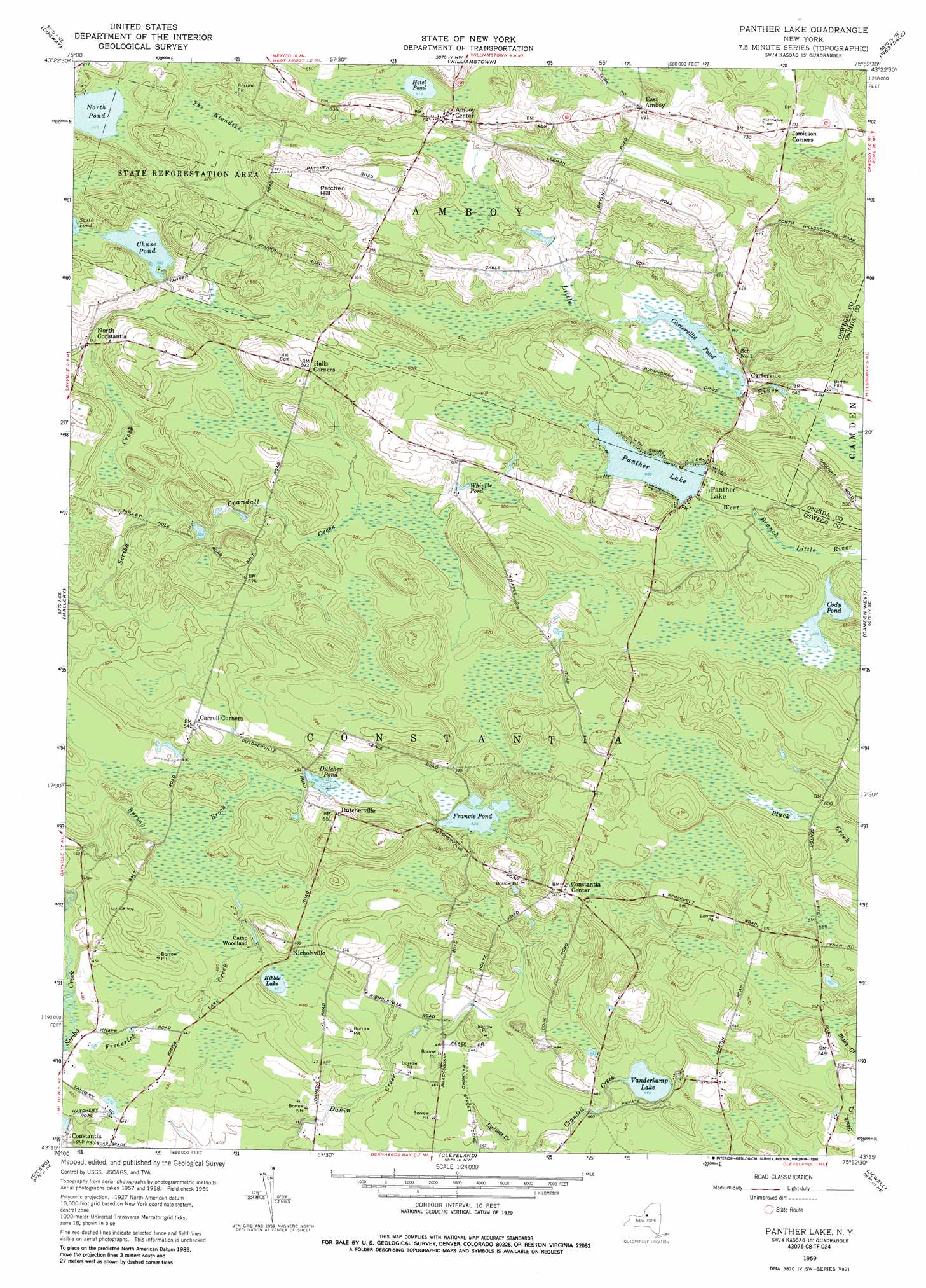
Panther Lake Topo Map New York
To zoom in, hover over the map of Panther Lake
USGS Topo Quad 43075c8 - 1:24,000 scale
| Topo Map Name: | Panther Lake |
| USGS Topo Quad ID: | 43075c8 |
| Print Size: | ca. 21 1/4" wide x 27" high |
| Southeast Coordinates: | 43.25° N latitude / 75.875° W longitude |
| Map Center Coordinates: | 43.3125° N latitude / 75.9375° W longitude |
| U.S. State: | NY |
| Filename: | o43075c8.jpg |
| Download Map JPG Image: | Panther Lake topo map 1:24,000 scale |
| Map Type: | Topographic |
| Topo Series: | 7.5´ |
| Map Scale: | 1:24,000 |
| Source of Map Images: | United States Geological Survey (USGS) |
| Alternate Map Versions: |
Panther Lake NY 1959, updated 1960 Download PDF Buy paper map Panther Lake NY 1959, updated 1972 Download PDF Buy paper map Panther Lake NY 1959, updated 1988 Download PDF Buy paper map Panther Lake NY 2010 Download PDF Buy paper map Panther Lake NY 2013 Download PDF Buy paper map Panther Lake NY 2016 Download PDF Buy paper map |
1:24,000 Topo Quads surrounding Panther Lake
Pulaski |
Richland |
Orwell |
Redfield |
North Osceola |
Mexico |
Dugway |
Williamstown |
Westdale |
Florence |
Central Square |
Mallory |
Panther Lake |
Camden West |
Camden East |
Brewerton |
Cicero |
Cleveland |
Jewell |
Sylvan Beach |
Syracuse West |
Syracuse East |
Manlius |
Canastota |
Oneida |
> Back to 43075a1 at 1:100,000 scale
> Back to 43074a1 at 1:250,000 scale
> Back to U.S. Topo Maps home
Panther Lake topo map: Gazetteer
Panther Lake: Airports
Shepard Airport elevation 115m 377′Panther Lake: Lakes
Butler Lake elevation 207m 679′Carterville Pond elevation 171m 561′
Chase Pond elevation 171m 561′
Cody Pond elevation 185m 606′
Dutcher Pond elevation 149m 488′
Francis Pond elevation 158m 518′
Hotel Pond elevation 188m 616′
Kibbie Lake elevation 143m 469′
North Pond elevation 175m 574′
Vanderkamp Lake elevation 142m 465′
Whipple Pond elevation 175m 574′
Panther Lake: Populated Places
Amboy Center elevation 199m 652′Carterville elevation 174m 570′
Constantia Center elevation 177m 580′
Dutcherville elevation 167m 547′
East Amboy elevation 212m 695′
Nicholsville elevation 151m 495′
North Constantia elevation 166m 544′
Panther Lake elevation 183m 600′
Panther Lake: Reservoirs
Panther Lake elevation 183m 600′Panther Lake: Streams
Crandall Creek elevation 155m 508′Frederick Creek elevation 115m 377′
Panther Lake: Summits
Patchen Hill elevation 211m 692′Panther Lake: Swamps
The Klondike elevation 175m 574′Panther Lake digital topo map on disk
Buy this Panther Lake topo map showing relief, roads, GPS coordinates and other geographical features, as a high-resolution digital map file on DVD:
New York, Vermont, Connecticut & Western Massachusetts
Buy digital topo maps: New York, Vermont, Connecticut & Western Massachusetts