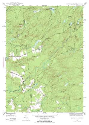
North Wilmurt Topo Map New York
To zoom in, hover over the map of North Wilmurt
USGS Topo Quad 43075d1 - 1:24,000 scale
| Topo Map Name: | North Wilmurt |
| USGS Topo Quad ID: | 43075d1 |
| Print Size: | ca. 21 1/4" wide x 27" high |
| Southeast Coordinates: | 43.375° N latitude / 75° W longitude |
| Map Center Coordinates: | 43.4375° N latitude / 75.0625° W longitude |
| U.S. State: | NY |
| Filename: | o43075d1.jpg |
| Download Map JPG Image: | North Wilmurt topo map 1:24,000 scale |
| Map Type: | Topographic |
| Topo Series: | 7.5´ |
| Map Scale: | 1:24,000 |
| Source of Map Images: | United States Geological Survey (USGS) |
| Alternate Map Versions: |
North Wilmurt NY 1946, updated 1958 Download PDF Buy paper map North Wilmurt NY 1946, updated 1965 Download PDF Buy paper map North Wilmurt NY 2010 Download PDF Buy paper map North Wilmurt NY 2013 Download PDF Buy paper map North Wilmurt NY 2016 Download PDF Buy paper map |
1:24,000 Topo Quads surrounding North Wilmurt
> Back to 43075a1 at 1:100,000 scale
> Back to 43074a1 at 1:250,000 scale
> Back to U.S. Topo Maps home
North Wilmurt topo map: Gazetteer
North Wilmurt: Lakes
Deep Lake elevation 438m 1437′Maple Lake elevation 403m 1322′
Mink Lake elevation 508m 1666′
Reeds Pond elevation 489m 1604′
Stone Dam Lake elevation 502m 1646′
North Wilmurt: Populated Places
North Wilmurt elevation 494m 1620′Wheelertown elevation 422m 1384′
North Wilmurt: Ridges
Ash Ridge elevation 507m 1663′North Wilmurt: Springs
Mulchy Spring elevation 470m 1541′North Wilmurt: Streams
Big Brook elevation 406m 1332′Halt Creek elevation 398m 1305′
Hare Brook elevation 401m 1315′
Muskrat Brook elevation 372m 1220′
North Branch Little Black Creek elevation 402m 1318′
Otter Brook elevation 482m 1581′
Stone Dam Creek elevation 465m 1525′
Twin Lakes Stream elevation 445m 1459′
Vincent Brook elevation 499m 1637′
North Wilmurt: Summits
Finn Hill elevation 545m 1788′Meyers Hill elevation 536m 1758′
Party Hill elevation 500m 1640′
Stone Dam Mountain elevation 550m 1804′
North Wilmurt: Swamps
Quagmire Swamp elevation 504m 1653′North Wilmurt: Trails
Forty Mountain Trail elevation 471m 1545′Stone Dam Trail elevation 465m 1525′
North Wilmurt digital topo map on disk
Buy this North Wilmurt topo map showing relief, roads, GPS coordinates and other geographical features, as a high-resolution digital map file on DVD:
New York, Vermont, Connecticut & Western Massachusetts
Buy digital topo maps: New York, Vermont, Connecticut & Western Massachusetts


