Point Rock Topo Map New York
To zoom in, hover over the map of Point Rock
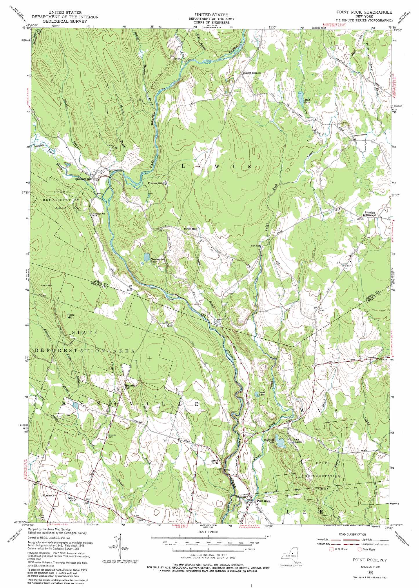
USGS Topo Quad 43075d5 - 1:24,000 scale
| Topo Map Name: | Point Rock |
| USGS Topo Quad ID: | 43075d5 |
| Print Size: | ca. 21 1/4" wide x 27" high |
| Southeast Coordinates: | 43.375° N latitude / 75.5° W longitude |
| Map Center Coordinates: | 43.4375° N latitude / 75.5625° W longitude |
| U.S. State: | NY |
| Filename: | o43075d5.jpg |
| Download Map JPG Image: | Point Rock topo map 1:24,000 scale |
| Map Type: | Topographic |
| Topo Series: | 7.5´ |
| Map Scale: | 1:24,000 |
| Source of Map Images: | United States Geological Survey (USGS) |
| Alternate Map Versions: |
Point Rock NY 1955, updated 1957 Download PDF Buy paper map Point Rock NY 1955, updated 1967 Download PDF Buy paper map Point Rock NY 1955, updated 1988 Download PDF Buy paper map Point Rock NY 1955, updated 1988 Download PDF Buy paper map Point Rock NY 2010 Download PDF Buy paper map Point Rock NY 2013 Download PDF Buy paper map Point Rock NY 2016 Download PDF Buy paper map |
1:24,000 Topo Quads surrounding Point Rock
Worth Center |
Sears Pond |
Page |
Glenfield |
Brantingham |
Redfield |
North Osceola |
High Market |
Constableville |
Port Leyden |
Westdale |
Florence |
Point Rock |
West Leyden |
Boonville |
Camden West |
Camden East |
Lee Center |
Westernville |
North Western |
Jewell |
Sylvan Beach |
Verona |
Rome |
Oriskany |
> Back to 43075a1 at 1:100,000 scale
> Back to 43074a1 at 1:250,000 scale
> Back to U.S. Topo Maps home
Point Rock topo map: Gazetteer
Point Rock: Lakes
Bloodsucker Lake elevation 389m 1276′Bullhead Lake elevation 345m 1131′
Mud Lake elevation 463m 1519′
Smith Lake elevation 352m 1154′
Point Rock: Populated Places
Fey Mill elevation 435m 1427′Freeman Mill elevation 428m 1404′
Parson Mill elevation 438m 1437′
Point Rock elevation 310m 1017′
Prussian Settlement elevation 491m 1610′
Swancott Mill elevation 401m 1315′
Point Rock: Streams
Beaver Meadow Brook elevation 415m 1361′Broad Brook elevation 434m 1423′
Cody Brook elevation 321m 1053′
Finn Brook elevation 335m 1099′
Harger Creek elevation 359m 1177′
Hennesey Brook elevation 321m 1053′
Heron Brook elevation 384m 1259′
Mack Brook elevation 315m 1033′
Mud Brook elevation 439m 1440′
Pigeon Brook elevation 343m 1125′
Point Rock Creek elevation 286m 938′
Pond Brook elevation 456m 1496′
Powlish Pond Brook elevation 384m 1259′
Searles Brook elevation 390m 1279′
Sullivan Brook elevation 326m 1069′
Point Rock: Summits
Bowman Hill elevation 405m 1328′Finn Hill elevation 427m 1400′
Point Rock digital topo map on disk
Buy this Point Rock topo map showing relief, roads, GPS coordinates and other geographical features, as a high-resolution digital map file on DVD:
New York, Vermont, Connecticut & Western Massachusetts
Buy digital topo maps: New York, Vermont, Connecticut & Western Massachusetts