Redfield Topo Map New York
To zoom in, hover over the map of Redfield
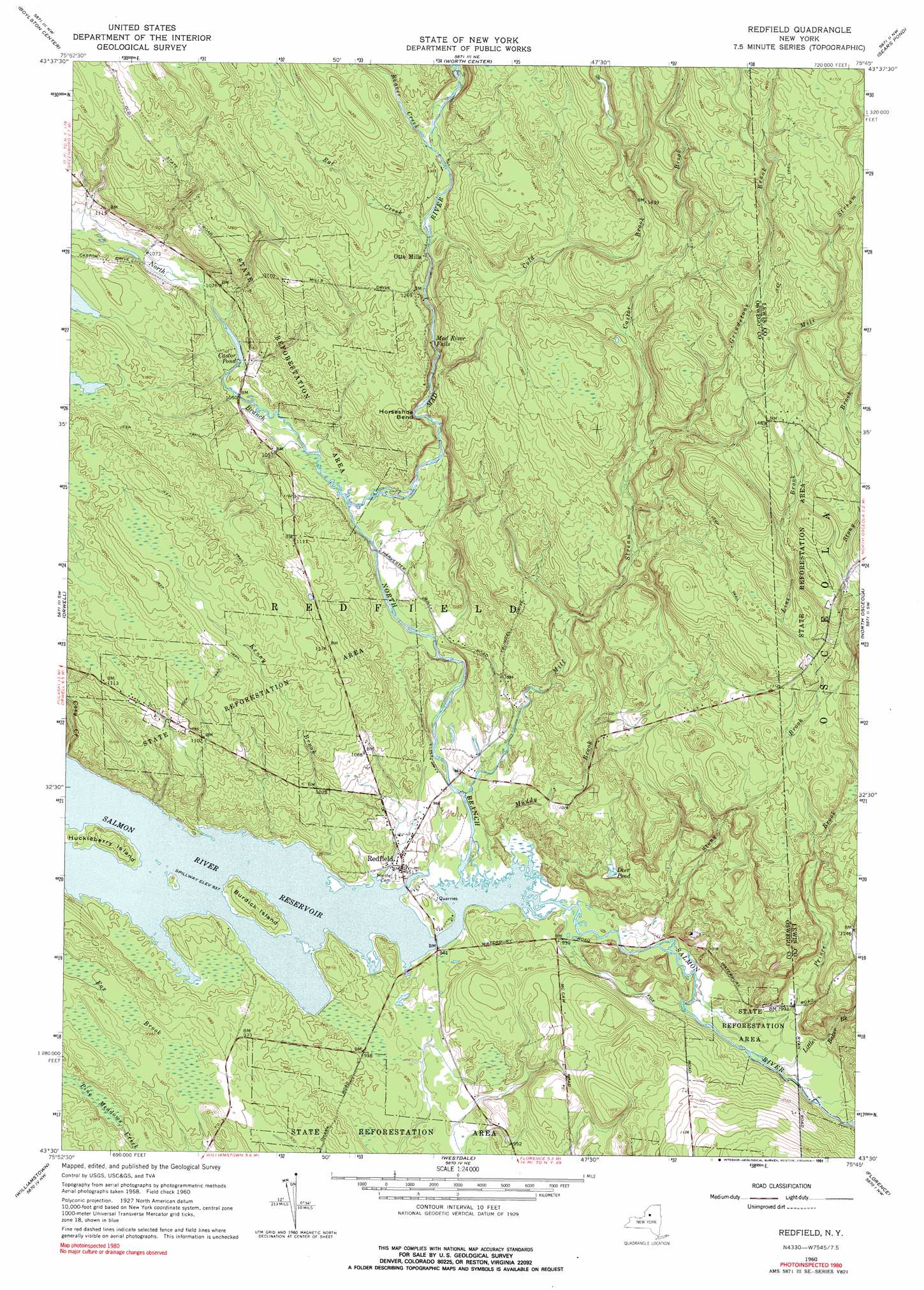
USGS Topo Quad 43075e7 - 1:24,000 scale
| Topo Map Name: | Redfield |
| USGS Topo Quad ID: | 43075e7 |
| Print Size: | ca. 21 1/4" wide x 27" high |
| Southeast Coordinates: | 43.5° N latitude / 75.75° W longitude |
| Map Center Coordinates: | 43.5625° N latitude / 75.8125° W longitude |
| U.S. State: | NY |
| Filename: | o43075e7.jpg |
| Download Map JPG Image: | Redfield topo map 1:24,000 scale |
| Map Type: | Topographic |
| Topo Series: | 7.5´ |
| Map Scale: | 1:24,000 |
| Source of Map Images: | United States Geological Survey (USGS) |
| Alternate Map Versions: |
Redfield NY 1942, updated 1958 Download PDF Buy paper map Redfield NY 1960, updated 1962 Download PDF Buy paper map Redfield NY 1960, updated 1969 Download PDF Buy paper map Redfield NY 1960, updated 1977 Download PDF Buy paper map Redfield NY 1960, updated 1991 Download PDF Buy paper map Redfield NY 2010 Download PDF Buy paper map Redfield NY 2013 Download PDF Buy paper map Redfield NY 2016 Download PDF Buy paper map |
1:24,000 Topo Quads surrounding Redfield
Adams |
Rodman |
Barnes Corners |
New Boston |
West Lowville |
Sandy Creek |
Boylston Center |
Worth Center |
Sears Pond |
Page |
Richland |
Orwell |
Redfield |
North Osceola |
High Market |
Dugway |
Williamstown |
Westdale |
Florence |
Point Rock |
Mallory |
Panther Lake |
Camden West |
Camden East |
Lee Center |
> Back to 43075e1 at 1:100,000 scale
> Back to 43074a1 at 1:250,000 scale
> Back to U.S. Topo Maps home
Redfield topo map: Gazetteer
Redfield: Bends
Horseshoe Bend elevation 353m 1158′Redfield: Falls
Mad River Falls elevation 378m 1240′Redfield: Islands
Burdick Island elevation 294m 964′Huckleberry Island elevation 292m 958′
Redfield: Lakes
Castor Pond elevation 318m 1043′Deer Pond elevation 307m 1007′
Redfield: Populated Places
Otto Mills elevation 387m 1269′Redfield elevation 289m 948′
Redfield: Streams
Beaver Creek elevation 399m 1309′Castor Brook elevation 391m 1282′
Coey Creek elevation 287m 941′
Cold Brook elevation 387m 1269′
Fox Brook elevation 288m 944′
Grindstone Brook elevation 410m 1345′
Kenny Brook elevation 285m 935′
Line Brook elevation 391m 1282′
Little Baker Brook elevation 285m 935′
Mad River elevation 313m 1026′
Mill Stream elevation 287m 941′
Muddy Brook elevation 285m 935′
North Branch Salmon River elevation 285m 935′
Prince Brook elevation 293m 961′
Rat Creek elevation 393m 1289′
Salmon River elevation 285m 935′
Stony Brook elevation 286m 938′
Redfield digital topo map on disk
Buy this Redfield topo map showing relief, roads, GPS coordinates and other geographical features, as a high-resolution digital map file on DVD:
New York, Vermont, Connecticut & Western Massachusetts
Buy digital topo maps: New York, Vermont, Connecticut & Western Massachusetts