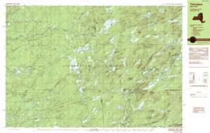
Thendara Topo Map New York
To zoom in, hover over the map of Thendara
USGS Topo Quad 43075f1 - 1:25,000 scale
| Topo Map Name: | Thendara |
| USGS Topo Quad ID: | 43075f1 |
| Print Size: | ca. 39" wide x 24" high |
| Southeast Coordinates: | 43.625° N latitude / 75° W longitude |
| Map Center Coordinates: | 43.6875° N latitude / 75.125° W longitude |
| U.S. State: | NY |
| Filename: | k43075f1.jpg |
| Download Map JPG Image: | Thendara topo map 1:25,000 scale |
| Map Type: | Topographic |
| Topo Series: | 7.5´x15´ |
| Map Scale: | 1:25,000 |
| Source of Map Images: | United States Geological Survey (USGS) |
| Alternate Map Versions: |
Thendara NY 1989, updated 1989 Download PDF Buy paper map Thendara NY 1989, updated 1989 Download PDF Buy paper map |
1:24,000 Topo Quads surrounding Thendara
> Back to 43075e1 at 1:100,000 scale
> Back to 43074a1 at 1:250,000 scale
> Back to U.S. Topo Maps home
Thendara topo map: Gazetteer
Thendara: Lakes
Beaver Pond elevation 530m 1738′Big Otter Lake elevation 483m 1584′
Blackfoot Pond elevation 586m 1922′
Bloodsucker Pond elevation 525m 1722′
Cedar Pond elevation 518m 1699′
Copper Lake elevation 478m 1568′
East Pine Pond elevation 477m 1564′
East Pond elevation 556m 1824′
Gibbs Lake elevation 565m 1853′
Goose Pond elevation 490m 1607′
Grass Pond elevation 548m 1797′
Gull Lake elevation 536m 1758′
Half Moon Pond elevation 559m 1833′
Lake Easka elevation 533m 1748′
Lake Tekeni elevation 535m 1755′
Little Pine Lake elevation 466m 1528′
Little Simon Pond elevation 547m 1794′
Lost Lake elevation 494m 1620′
Middle Branch Lake elevation 496m 1627′
Middle Settlement Lake elevation 526m 1725′
Mudhole Pond elevation 462m 1515′
Nelson Lake elevation 487m 1597′
North Pond elevation 495m 1624′
Okara Lakes elevation 547m 1794′
Pine Lake elevation 472m 1548′
Rock Pond elevation 547m 1794′
Tamarack Lake elevation 509m 1669′
Tamarack Lake elevation 510m 1673′
West Pine Pond elevation 475m 1558′
West Pond elevation 508m 1666′
Wheeler Pond elevation 527m 1729′
Thendara: Populated Places
Minnehaha elevation 513m 1683′Thendara elevation 520m 1706′
Thendara: Streams
Drunkard Creek elevation 391m 1282′Emerson Creek elevation 401m 1315′
Indian Brook elevation 522m 1712′
Lost Creek elevation 484m 1587′
Lost Creek elevation 483m 1584′
Middle Branch Pine Creek elevation 462m 1515′
Middle Settlement Creek elevation 503m 1650′
Mink Run elevation 513m 1683′
Nicks Creek elevation 462m 1515′
North Inlet elevation 483m 1584′
South Inlet elevation 483m 1584′
Stony Creek elevation 472m 1548′
Tommy Roaring Creek elevation 467m 1532′
Thendara: Summits
Bare Mountain elevation 613m 2011′Flatrock Mountain elevation 625m 2050′
Jones Mountain elevation 640m 2099′
Little Roundtop elevation 618m 2027′
Moose River Mountain elevation 673m 2208′
Tooker Mountain elevation 621m 2037′
Tooker Mountain elevation 617m 2024′
Thendara digital topo map on disk
Buy this Thendara topo map showing relief, roads, GPS coordinates and other geographical features, as a high-resolution digital map file on DVD:
New York, Vermont, Connecticut & Western Massachusetts
Buy digital topo maps: New York, Vermont, Connecticut & Western Massachusetts


