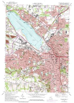
Syracuse West Topo Map New York
To zoom in, hover over the map of Syracuse West
USGS Topo Quad 43076a2 - 1:24,000 scale
| Topo Map Name: | Syracuse West |
| USGS Topo Quad ID: | 43076a2 |
| Print Size: | ca. 21 1/4" wide x 27" high |
| Southeast Coordinates: | 43° N latitude / 76.125° W longitude |
| Map Center Coordinates: | 43.0625° N latitude / 76.1875° W longitude |
| U.S. State: | NY |
| Filename: | o43076a2.jpg |
| Download Map JPG Image: | Syracuse West topo map 1:24,000 scale |
| Map Type: | Topographic |
| Topo Series: | 7.5´ |
| Map Scale: | 1:24,000 |
| Source of Map Images: | United States Geological Survey (USGS) |
| Alternate Map Versions: |
Syracuse West NY 1939 Download PDF Buy paper map Syracuse West NY 1939 Download PDF Buy paper map Syracuse West NY 1958, updated 1960 Download PDF Buy paper map Syracuse West NY 1958, updated 1965 Download PDF Buy paper map Syracuse West NY 1973, updated 1975 Download PDF Buy paper map Syracuse West NY 1973, updated 1979 Download PDF Buy paper map Syracuse West NY 2010 Download PDF Buy paper map Syracuse West NY 2013 Download PDF Buy paper map Syracuse West NY 2016 Download PDF Buy paper map |
1:24,000 Topo Quads surrounding Syracuse West
> Back to 43076a1 at 1:100,000 scale
> Back to 43076a1 at 1:250,000 scale
> Back to U.S. Topo Maps home
Syracuse West topo map: Gazetteer
Syracuse West: Airports
Crouse Irving Memorial Hospital Heliport elevation 182m 597′Onondaga Lake Seaplane Base elevation 110m 360′
Suny Health Science Center Heliport elevation 127m 416′
Syracuse West: Bays
Maple Bay elevation 110m 360′Syracuse West: Capes
Hiawatha Point elevation 111m 364′Lakeview Point elevation 126m 413′
Syracuse West: Channels
Lake Outlet elevation 110m 360′Syracuse West: Crossings
Interchange 36 elevation 117m 383′Interchange 37 elevation 136m 446′
Interchange 38 elevation 123m 403′
Syracuse West: Harbors
Marina Basin elevation 110m 360′Syracuse West: Lakes
Hiawatha Lake elevation 155m 508′Onondaga Lake elevation 110m 360′
Tunnel Reservoir elevation 215m 705′
Westcott Reservoir elevation 190m 623′
Woodland Reservoir elevation 191m 626′
Syracuse West: Parks
Alliance Bank Stadium elevation 113m 370′Archbold Stadium (historical) elevation 163m 534′
Burnet Park elevation 164m 538′
Elmwood Park elevation 145m 475′
J. Stanley Coyne Stadium elevation 166m 544′
Johnson Park elevation 120m 393′
Kirk Park elevation 121m 396′
Lamb Park elevation 117m 383′
Lincoln Park elevation 179m 587′
MacArthur Stadium (historical) elevation 114m 374′
McKinley Playground elevation 125m 410′
Onondaga Lake Park elevation 111m 364′
Onondaga Park elevation 123m 403′
Schiller Park elevation 170m 557′
Thornden Park elevation 177m 580′
Town Park South elevation 125m 410′
Village Green elevation 122m 400′
Washington Park elevation 115m 377′
Syracuse West: Populated Places
Fairmount elevation 150m 492′Galeville elevation 129m 423′
Hinsdale elevation 128m 419′
Lakeland elevation 146m 479′
Lemoyne Mobile Home Park elevation 128m 419′
Liverpool elevation 128m 419′
Long Branch elevation 111m 364′
Loomis Hill elevation 257m 843′
Lyncourt elevation 136m 446′
Mattydale elevation 123m 403′
Onondaga Hill elevation 271m 889′
Pitcher Hill elevation 125m 410′
Pleasant View elevation 121m 396′
Solvay elevation 152m 498′
Split Rock elevation 211m 692′
Syracuse elevation 121m 396′
Taunton elevation 153m 501′
Westvale elevation 154m 505′
Syracuse West: Streams
Beartrap Creek elevation 111m 364′Furnace Brook elevation 136m 446′
Geddes Brook elevation 110m 360′
Harbor Brook elevation 119m 390′
Ley Creek elevation 110m 360′
Ninemile Creek elevation 111m 364′
Onondaga Creek elevation 110m 360′
Sawmill Creek elevation 111m 364′
Split Rock Gulf elevation 204m 669′
Syracuse West: Summits
Chestnut Ridge elevation 146m 479′Syracuse West digital topo map on disk
Buy this Syracuse West topo map showing relief, roads, GPS coordinates and other geographical features, as a high-resolution digital map file on DVD:
New York, Vermont, Connecticut & Western Massachusetts
Buy digital topo maps: New York, Vermont, Connecticut & Western Massachusetts


