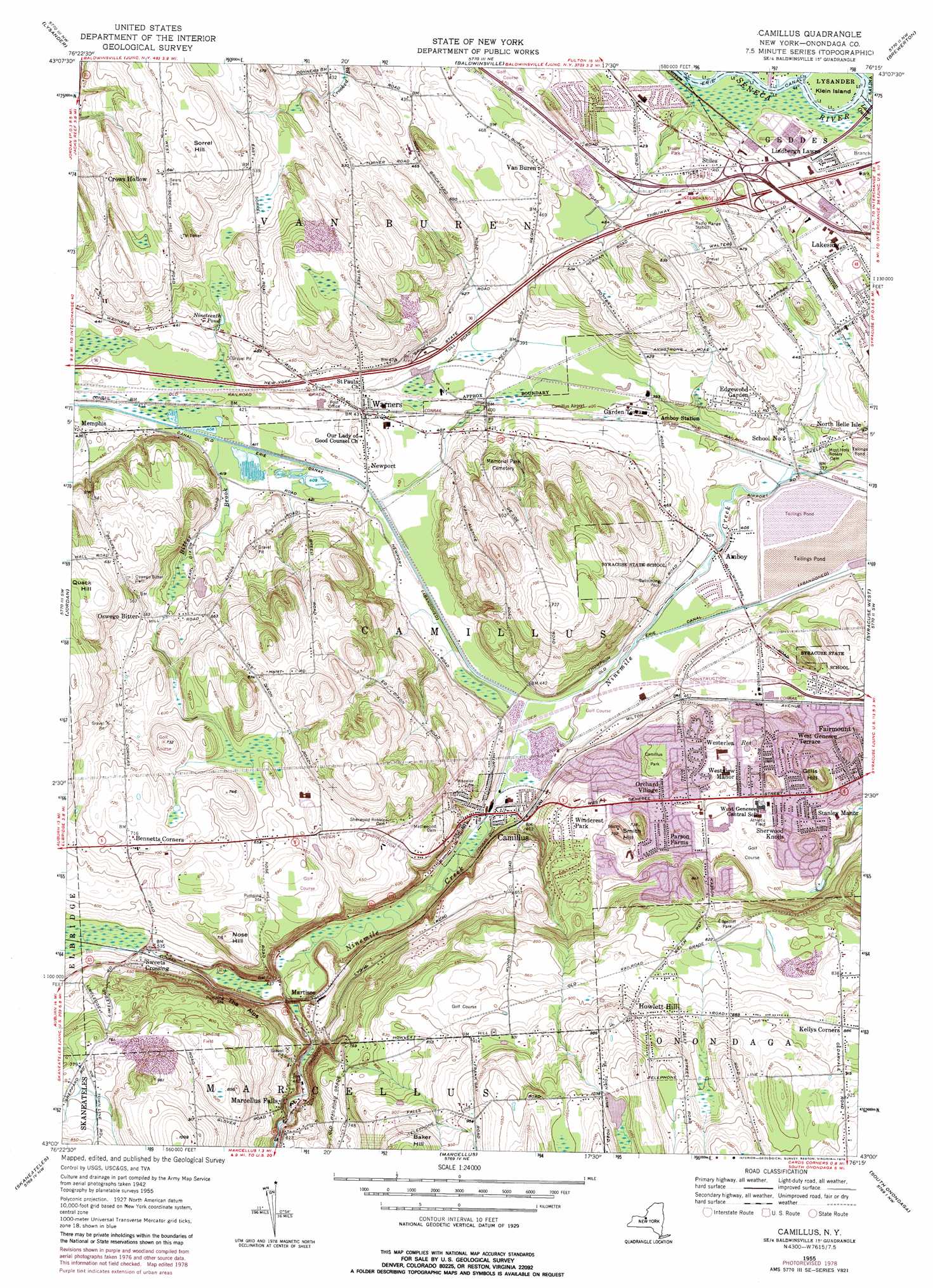
Camillus Topo Map New York
To zoom in, hover over the map of Camillus
USGS Topo Quad 43076a3 - 1:24,000 scale
| Topo Map Name: | Camillus |
| USGS Topo Quad ID: | 43076a3 |
| Print Size: | ca. 21 1/4" wide x 27" high |
| Southeast Coordinates: | 43° N latitude / 76.25° W longitude |
| Map Center Coordinates: | 43.0625° N latitude / 76.3125° W longitude |
| U.S. State: | NY |
| Filename: | o43076a3.jpg |
| Download Map JPG Image: | Camillus topo map 1:24,000 scale |
| Map Type: | Topographic |
| Topo Series: | 7.5´ |
| Map Scale: | 1:24,000 |
| Source of Map Images: | United States Geological Survey (USGS) |
| Alternate Map Versions: |
Camillus NY 1943, updated 1951 Download PDF Buy paper map Camillus NY 1943, updated 1953 Download PDF Buy paper map Camillus NY 1955, updated 1957 Download PDF Buy paper map Camillus NY 1955, updated 1965 Download PDF Buy paper map Camillus NY 2011 Download PDF Buy paper map Camillus NY 2013 Download PDF Buy paper map Camillus NY 2016 Download PDF Buy paper map |
1:24,000 Topo Quads surrounding Camillus
Hannibal |
Fulton |
Pennellville |
Central Square |
Mallory |
Cato |
Lysander |
Baldwinsville |
Brewerton |
Cicero |
Weedsport |
Jordan |
Camillus |
Syracuse West |
Syracuse East |
Auburn |
Skaneateles |
Marcellus |
South Onondaga |
Jamesville |
Scipio Center |
Owasco |
Spafford |
Otisco Valley |
Tully |
> Back to 43076a1 at 1:100,000 scale
> Back to 43076a1 at 1:250,000 scale
> Back to U.S. Topo Maps home
Camillus topo map: Gazetteer
Camillus: Airports
Camillus Airport elevation 124m 406′Marcellus Airport elevation 249m 816′
Onondaga County Sheriffs Department Heliport elevation 123m 403′
Syracuse Municipal Airport (historical) elevation 120m 393′
Camillus: Cliffs
The Alps elevation 190m 623′Camillus: Islands
Klein Island elevation 110m 360′Camillus: Lakes
Nineteenth Pond elevation 142m 465′Camillus: Parks
Camillus Park elevation 170m 557′Edgecliff Park elevation 246m 807′
Long Branch Park elevation 115m 377′
Camillus: Populated Places
Amboy elevation 122m 400′Bennetts Corners elevation 217m 711′
Camillus elevation 132m 433′
Edgewood Garden elevation 124m 406′
Garden Terrace elevation 122m 400′
Howlett Hill elevation 298m 977′
Kellys Corners elevation 269m 882′
Lakeside elevation 123m 403′
Lindbergh Lawns elevation 117m 383′
Marcellus Falls elevation 155m 508′
Martisco elevation 151m 495′
Newport elevation 128m 419′
North Belle Isle elevation 123m 403′
Orchard Village elevation 171m 561′
Oswego Bitter elevation 171m 561′
Parson Farms elevation 187m 613′
Seneca Knolls elevation 124m 406′
Sherwood Knolls elevation 178m 583′
Stanley Manor elevation 167m 547′
Stiles elevation 132m 433′
Sweets Crossing elevation 162m 531′
Van Buren elevation 152m 498′
Warners elevation 131m 429′
West Genesee Terrace elevation 171m 561′
Westerlea elevation 168m 551′
Westview Manor elevation 179m 587′
Windcrest Park elevation 188m 616′
Camillus: Streams
Bitter Brook elevation 125m 410′Camillus: Summits
Gillis Hill elevation 225m 738′Nose Hill elevation 217m 711′
Smith Hill elevation 239m 784′
Sorrel Hill elevation 196m 643′
Camillus digital topo map on disk
Buy this Camillus topo map showing relief, roads, GPS coordinates and other geographical features, as a high-resolution digital map file on DVD:
New York, Vermont, Connecticut & Western Massachusetts
Buy digital topo maps: New York, Vermont, Connecticut & Western Massachusetts