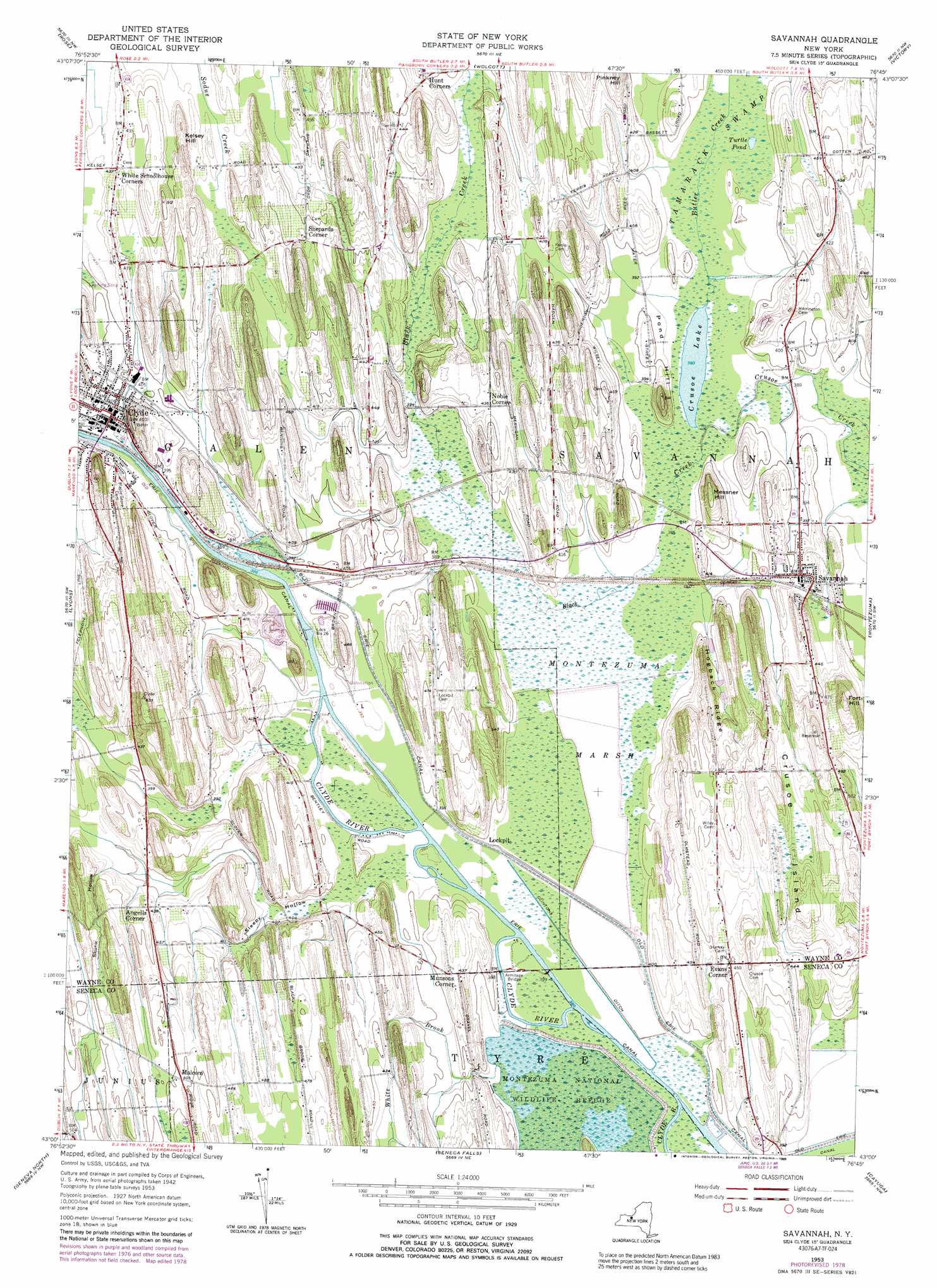
Savannah Topo Map New York
To zoom in, hover over the map of Savannah
USGS Topo Quad 43076a7 - 1:24,000 scale
| Topo Map Name: | Savannah |
| USGS Topo Quad ID: | 43076a7 |
| Print Size: | ca. 21 1/4" wide x 27" high |
| Southeast Coordinates: | 43° N latitude / 76.75° W longitude |
| Map Center Coordinates: | 43.0625° N latitude / 76.8125° W longitude |
| U.S. State: | NY |
| Filename: | o43076a7.jpg |
| Download Map JPG Image: | Savannah topo map 1:24,000 scale |
| Map Type: | Topographic |
| Topo Series: | 7.5´ |
| Map Scale: | 1:24,000 |
| Source of Map Images: | United States Geological Survey (USGS) |
| Alternate Map Versions: |
Savannah NY 1953, updated 1955 Download PDF Buy paper map Savannah NY 1953, updated 1966 Download PDF Buy paper map Savannah NY 1953, updated 1979 Download PDF Buy paper map Savannah NY 1953, updated 1989 Download PDF Buy paper map Savannah NY 2010 Download PDF Buy paper map Savannah NY 2013 Download PDF Buy paper map Savannah NY 2016 Download PDF Buy paper map |
1:24,000 Topo Quads surrounding Savannah
Salmon Creek |
Sodus Point |
North Wolcott |
Fair Haven |
Hannibal |
Sodus |
Rose |
Wolcott |
Victory |
Cato |
Newark |
Lyons |
Savannah |
Montezuma |
Weedsport |
Phelps |
Geneva North |
Seneca Falls |
Cayuga |
Auburn |
Stanley |
Geneva South |
Romulus |
Union Springs |
Scipio Center |
> Back to 43076a1 at 1:100,000 scale
> Back to 43076a1 at 1:250,000 scale
> Back to U.S. Topo Maps home
Savannah topo map: Gazetteer
Savannah: Bridges
Armitage Bridge elevation 116m 380′Savannah: Canals
Clintons Ditch elevation 117m 383′Savannah: Lakes
Crusoe Lake elevation 116m 380′Turtle Pond elevation 118m 387′
Savannah: Populated Places
Angells Corner elevation 131m 429′Clyde elevation 122m 400′
Daboll Corners elevation 120m 393′
Evans Corner elevation 137m 449′
Fort Hill elevation 170m 557′
Lockpit elevation 121m 396′
Malcon elevation 154m 505′
Munsons Corner elevation 134m 439′
Noble Corner elevation 132m 433′
Savannah elevation 128m 419′
Shepards Corner elevation 143m 469′
Wiley Corner elevation 155m 508′
Savannah: Ridges
Hogback Ridge elevation 150m 492′Savannah: Streams
Black Creek elevation 116m 380′Butler Creek elevation 116m 380′
White Brook elevation 116m 380′
Savannah: Summits
Crusoe Island elevation 152m 498′Kelsey Hill elevation 150m 492′
Messner Hill elevation 154m 505′
Pond Hill elevation 154m 505′
Savannah: Swamps
Tamarack Swamp elevation 116m 380′Savannah: Valleys
Skunk Hollow elevation 130m 426′Sleepy Hollow elevation 116m 380′
Savannah digital topo map on disk
Buy this Savannah topo map showing relief, roads, GPS coordinates and other geographical features, as a high-resolution digital map file on DVD:
New York, Vermont, Connecticut & Western Massachusetts
Buy digital topo maps: New York, Vermont, Connecticut & Western Massachusetts