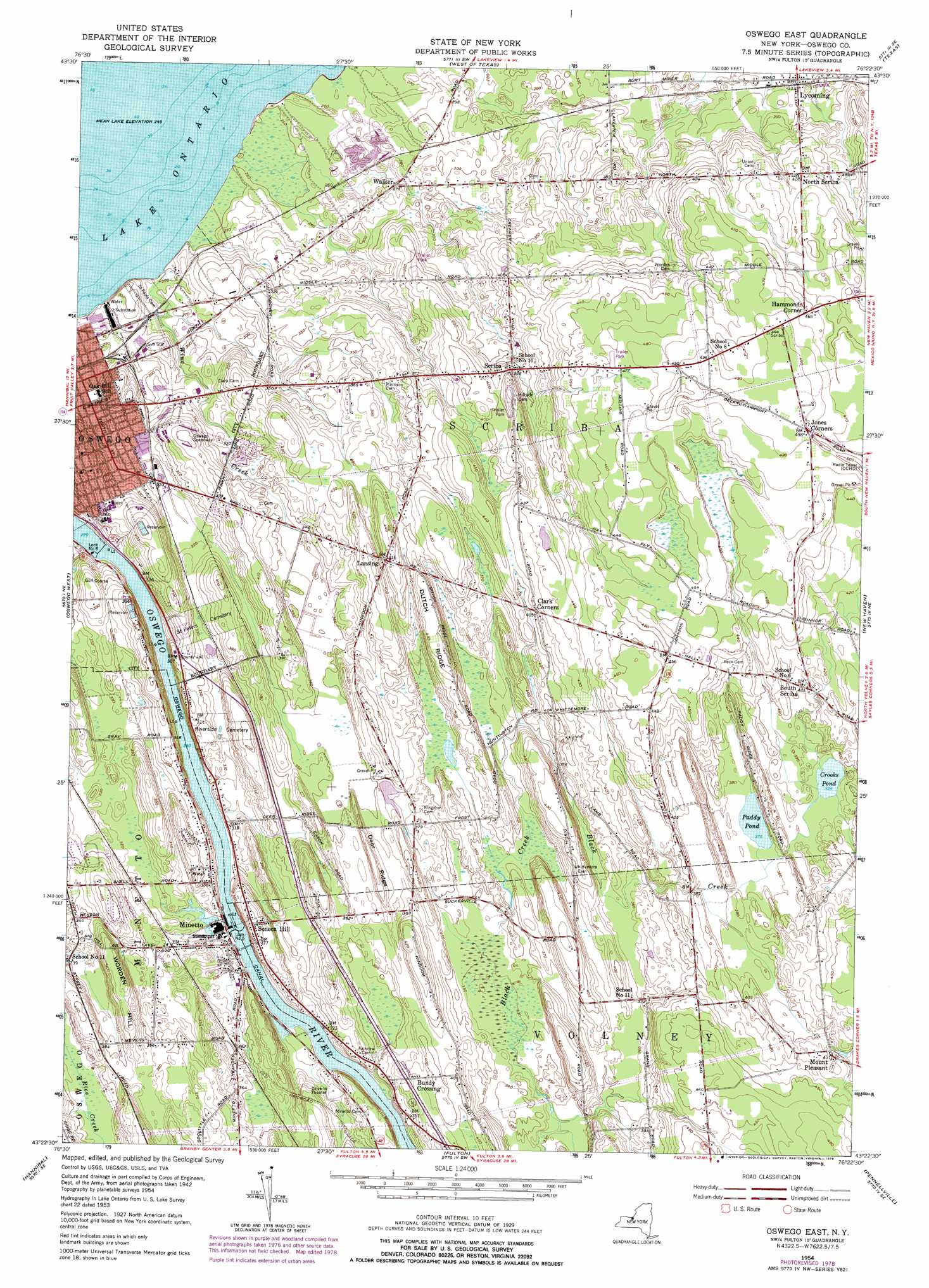
Oswego East Topo Map New York
To zoom in, hover over the map of Oswego East
USGS Topo Quad 43076d4 - 1:24,000 scale
| Topo Map Name: | Oswego East |
| USGS Topo Quad ID: | 43076d4 |
| Print Size: | ca. 21 1/4" wide x 27" high |
| Southeast Coordinates: | 43.375° N latitude / 76.375° W longitude |
| Map Center Coordinates: | 43.4375° N latitude / 76.4375° W longitude |
| U.S. State: | NY |
| Filename: | o43076d4.jpg |
| Download Map JPG Image: | Oswego East topo map 1:24,000 scale |
| Map Type: | Topographic |
| Topo Series: | 7.5´ |
| Map Scale: | 1:24,000 |
| Source of Map Images: | United States Geological Survey (USGS) |
| Alternate Map Versions: |
Oswego East NY 1954, updated 1956 Download PDF Buy paper map Oswego East NY 1954, updated 1969 Download PDF Buy paper map Oswego East NY 1954, updated 1979 Download PDF Buy paper map Oswego East NY 2010 Download PDF Buy paper map Oswego East NY 2013 Download PDF Buy paper map Oswego East NY 2016 Download PDF Buy paper map |
1:24,000 Topo Quads surrounding Oswego East
Ellisburg |
||||
West Of Texas |
Texas |
Pulaski |
||
West Ninemile Point |
Oswego West |
Oswego East |
New Haven |
Mexico |
Fair Haven |
Hannibal |
Fulton |
Pennellville |
Central Square |
Victory |
Cato |
Lysander |
Baldwinsville |
Brewerton |
> Back to 43076a1 at 1:100,000 scale
> Back to 43076a1 at 1:250,000 scale
> Back to U.S. Topo Maps home
Oswego East topo map: Gazetteer
Oswego East: Dams
Lock Number 5 elevation 93m 305′Lock Number 6 elevation 82m 269′
Oswego East: Lakes
Crooks Pond elevation 115m 377′Paddy Pond elevation 114m 374′
Oswego East: Parks
Fitzhugh Park elevation 86m 282′Oswego East: Populated Places
Bundy Crossing elevation 116m 380′Clark Corners elevation 124m 406′
Hammonds Corner elevation 141m 462′
Jones Corners elevation 150m 492′
Lansing elevation 126m 413′
Lycoming elevation 102m 334′
Minetto elevation 99m 324′
Mount Pleasant elevation 130m 426′
North Scriba elevation 131m 429′
Scriba elevation 112m 367′
Seneca Hill elevation 120m 393′
South Scriba elevation 127m 416′
Walker elevation 82m 269′
Oswego East: Ridges
Deer Ridge elevation 119m 390′Dutch Ridge elevation 132m 433′
Oswego East: Streams
Wine Creek elevation 76m 249′Oswego East: Summits
Worden Hill elevation 131m 429′Oswego East digital topo map on disk
Buy this Oswego East topo map showing relief, roads, GPS coordinates and other geographical features, as a high-resolution digital map file on DVD:
New York, Vermont, Connecticut & Western Massachusetts
Buy digital topo maps: New York, Vermont, Connecticut & Western Massachusetts