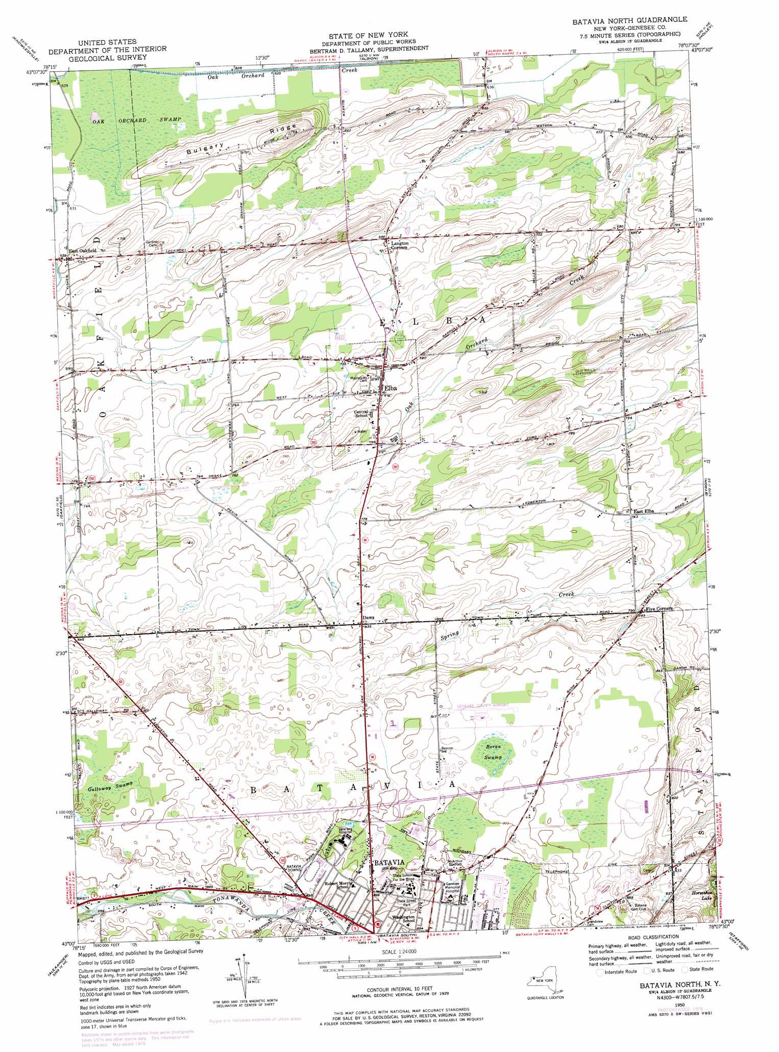
Batavia North Topo Map New York
To zoom in, hover over the map of Batavia North
USGS Topo Quad 43078a2 - 1:24,000 scale
| Topo Map Name: | Batavia North |
| USGS Topo Quad ID: | 43078a2 |
| Print Size: | ca. 21 1/4" wide x 27" high |
| Southeast Coordinates: | 43° N latitude / 78.125° W longitude |
| Map Center Coordinates: | 43.0625° N latitude / 78.1875° W longitude |
| U.S. State: | NY |
| Filename: | o43078a2.jpg |
| Download Map JPG Image: | Batavia North topo map 1:24,000 scale |
| Map Type: | Topographic |
| Topo Series: | 7.5´ |
| Map Scale: | 1:24,000 |
| Source of Map Images: | United States Geological Survey (USGS) |
| Alternate Map Versions: |
Batavia North NY 1950, updated 1970 Download PDF Buy paper map Batavia North NY 1950, updated 1978 Download PDF Buy paper map Batavia North NY 1951 Download PDF Buy paper map Batavia North NY 2010 Download PDF Buy paper map Batavia North NY 2013 Download PDF Buy paper map Batavia North NY 2016 Download PDF Buy paper map |
1:24,000 Topo Quads surrounding Batavia North
Lyndonville |
Ashwood |
Kent |
Kendall |
Hamlin |
Medina |
Knowlesville |
Albion |
Holley |
Brockport |
Akron |
Oakfield |
Batavia North |
Byron |
Churchville |
Alexander |
Batavia South |
Stafford |
Le Roy |
|
Cowlesville |
Attica |
Dale |
Wyoming |
Leicester |
> Back to 43078a1 at 1:100,000 scale
> Back to 43078a1 at 1:250,000 scale
> Back to U.S. Topo Maps home
Batavia North topo map: Gazetteer
Batavia North: Airports
Genesee County Airport elevation 277m 908′Troop A Headquarters Heliport elevation 274m 898′
Batavia North: Parks
McArthur Stadium elevation 274m 898′Ross Park elevation 274m 898′
State Street Park elevation 279m 915′
Woodward Field elevation 274m 898′
Batavia North: Populated Places
Batavia Downs Trailer Park elevation 275m 902′Country Meadows elevation 268m 879′
Daws elevation 254m 833′
Dreamland Mobile Home Park elevation 268m 879′
East Elba elevation 226m 741′
East Oakfield elevation 201m 659′
Elba elevation 232m 761′
Five Corners elevation 237m 777′
Genesee West elevation 275m 902′
Langton Corners elevation 210m 688′
Batavia North: Ridges
Bulgary Ridge elevation 209m 685′Batavia North: Streams
Manning Muckland Creek elevation 192m 629′Batavia North: Swamps
Borau Swamp elevation 276m 905′Batavia North digital topo map on disk
Buy this Batavia North topo map showing relief, roads, GPS coordinates and other geographical features, as a high-resolution digital map file on DVD:
 map DVD")