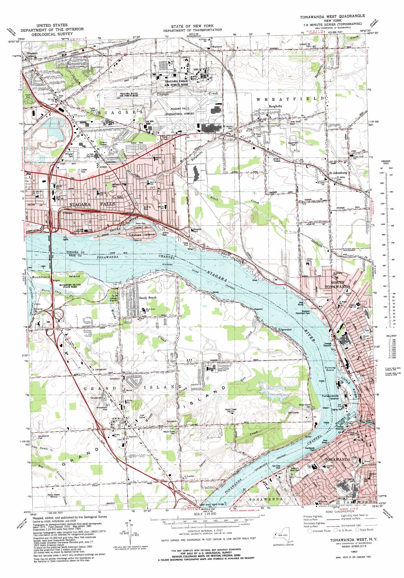
Tonawanda West Topo Map New York
To zoom in, hover over the map of Tonawanda West
USGS Topo Quad 43078a8 - 1:25,000 scale
| Topo Map Name: | Tonawanda West |
| USGS Topo Quad ID: | 43078a8 |
| Print Size: | ca. 21 1/4" wide x 27" high |
| Southeast Coordinates: | 43° N latitude / 78.875° W longitude |
| Map Center Coordinates: | 43.0625° N latitude / 78.9375° W longitude |
| U.S. State: | NY |
| Filename: | l43078a8.jpg |
| Download Map JPG Image: | Tonawanda West topo map 1:25,000 scale |
| Map Type: | Topographic |
| Topo Series: | 7.5´ |
| Map Scale: | 1:25,000 |
| Source of Map Images: | United States Geological Survey (USGS) |
| Alternate Map Versions: |
Tonawanda West NY 1954 Download PDF Buy paper map Tonawanda West NY 1980, updated 1980 Download PDF Buy paper map |
1:24,000 Topo Quads surrounding Tonawanda West
Fort Niagara |
Six Mile Creek |
Wilson |
Newfane |
|
Lewiston |
Ransomville |
Cambria |
Lockport |
|
Niagara Falls |
Tonawanda West |
Tonawanda East |
Clarence Center |
|
Buffalo Nw |
Buffalo Ne |
|||
Buffalo Se |
Orchard Park |
> Back to 43078a1 at 1:100,000 scale
> Back to 43078a1 at 1:250,000 scale
> Back to U.S. Topo Maps home
Tonawanda West topo map: Gazetteer
Tonawanda West: Airports
Best Western Red Jacket Inn Heliport elevation 171m 561′Niagara Falls International Airport elevation 178m 583′
Ross Heliport elevation 184m 603′
Tonawanda West: Bars
Nice Shoal elevation 171m 561′Tonawanda West: Bridges
North Grand Island Bridge elevation 171m 561′Tonawanda West: Canals
Love Canal (historical) elevation 175m 574′Tonawanda West: Channels
Tonawanda Channel elevation 171m 561′Tonawanda West: Islands
Buckhorn Island elevation 173m 567′Cayuga Island elevation 174m 570′
Grand Island elevation 178m 583′
Tonawanda Island elevation 174m 570′
Tonawanda West: Parks
Buckhorn Island State Park elevation 174m 570′Clinton Park elevation 174m 570′
Gratwick Waterfront Park elevation 175m 574′
Griffon Park elevation 175m 574′
Hennepin Park elevation 174m 570′
Isle View Park elevation 174m 570′
Jayne Park elevation 174m 570′
Nia-Wanda Park elevation 175m 574′
Nintyfirst Street Park elevation 175m 574′
Oppenheim Park elevation 175m 574′
Payne Park elevation 175m 574′
Veterans Memorial Park elevation 182m 597′
Tonawanda West: Populated Places
Bergholtz elevation 177m 580′Black Creek Village elevation 174m 570′
Edgewater elevation 175m 574′
La Salle elevation 175m 574′
Love Canal elevation 175m 574′
Pletchers Corners elevation 183m 600′
Saint Johnsburg elevation 175m 574′
Sandy Beach elevation 174m 570′
Sour Spring Grove elevation 180m 590′
Tonawanda elevation 175m 574′
Walmore elevation 187m 613′
Tonawanda West: Streams
Bergholtz Creek elevation 173m 567′Black Creek elevation 174m 570′
Burnt Ship Creek elevation 171m 561′
Cayuga Creek elevation 172m 564′
Ellicott Creek elevation 171m 561′
Gun Creek elevation 174m 570′
Little River elevation 171m 561′
Spicer Creek elevation 171m 561′
Tonawanda Creek elevation 171m 561′
Twomile Creek elevation 172m 564′
Woods Creek elevation 171m 561′
Tonawanda West: Wells
Lockport Intake elevation 171m 561′North Tonawanda Intake elevation 171m 561′
Tonawanda Intake elevation 171m 561′
Tonawanda West digital topo map on disk
Buy this Tonawanda West topo map showing relief, roads, GPS coordinates and other geographical features, as a high-resolution digital map file on DVD:
 map DVD")