Forestville Topo Map Michigan
To zoom in, hover over the map of Forestville
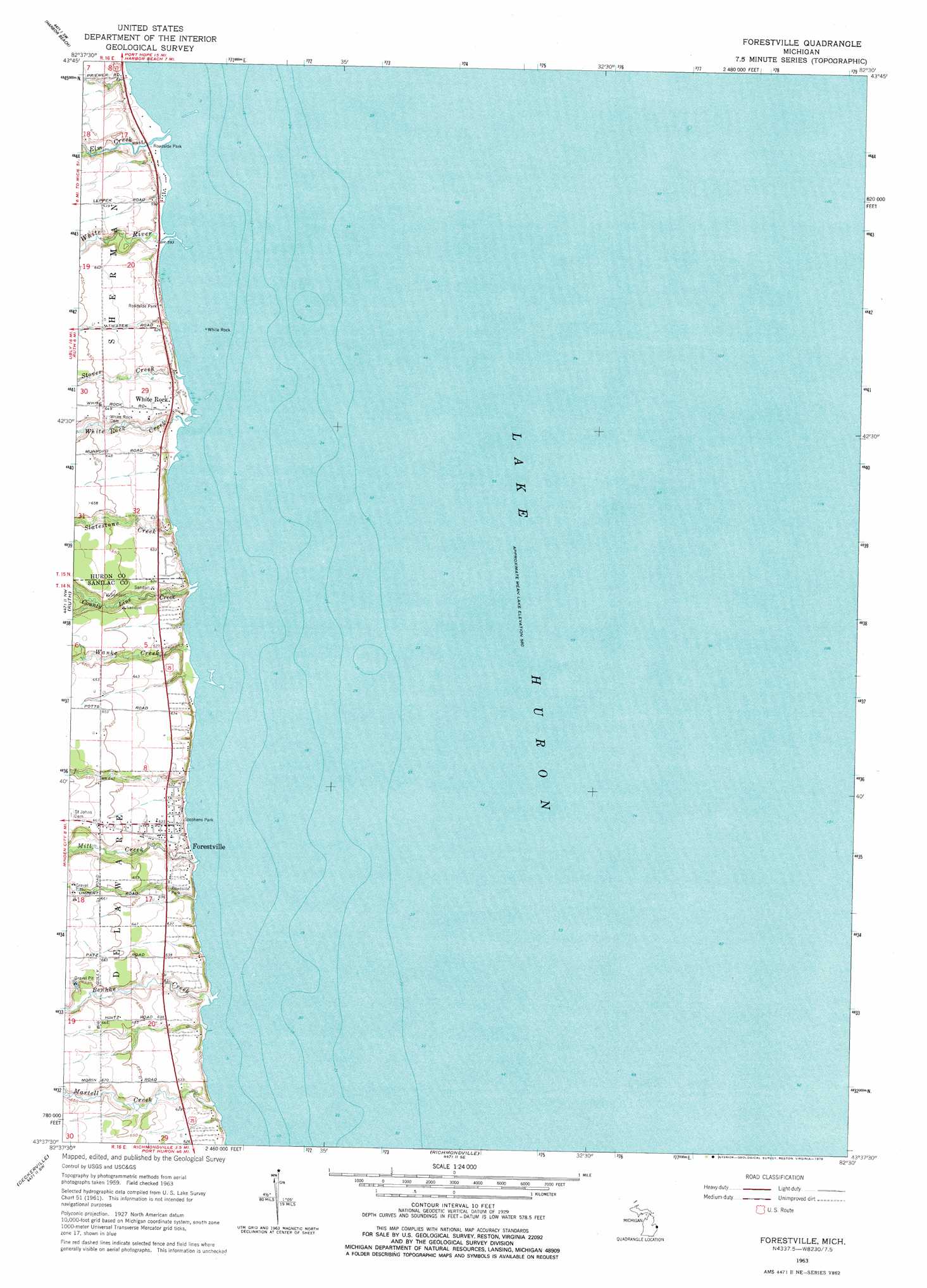
USGS Topo Quad 43082f5 - 1:24,000 scale
| Topo Map Name: | Forestville |
| USGS Topo Quad ID: | 43082f5 |
| Print Size: | ca. 21 1/4" wide x 27" high |
| Southeast Coordinates: | 43.625° N latitude / 82.5° W longitude |
| Map Center Coordinates: | 43.6875° N latitude / 82.5625° W longitude |
| U.S. State: | MI |
| Filename: | o43082f5.jpg |
| Download Map JPG Image: | Forestville topo map 1:24,000 scale |
| Map Type: | Topographic |
| Topo Series: | 7.5´ |
| Map Scale: | 1:24,000 |
| Source of Map Images: | United States Geological Survey (USGS) |
| Alternate Map Versions: |
Forestville MI 1963, updated 1964 Download PDF Buy paper map Forestville MI 1963, updated 1978 Download PDF Buy paper map Forestville MI 2011 Download PDF Buy paper map Forestville MI 2014 Download PDF Buy paper map Forestville MI 2016 Download PDF Buy paper map |
1:24,000 Topo Quads surrounding Forestville
Redman |
Port Hope |
|||
Bad Axe Se |
Harbor Beach |
|||
Minden City |
Ruth |
Forestville |
||
Palms |
Deckerville |
Richmondville |
||
Sandusky |
Carsonville |
Port Sanilac |
> Back to 43082e1 at 1:100,000 scale
> Back to 43082a1 at 1:250,000 scale
> Back to U.S. Topo Maps home
Forestville topo map: Gazetteer
Forestville: Bars
The Flats elevation 176m 577′Wankes Reef elevation 176m 577′
Forestville: Islands
White Rock elevation 176m 577′Forestville: Parks
Stephens Park elevation 188m 616′White Rock School Historical Marker elevation 190m 623′
Forestville: Populated Places
Forestville elevation 193m 633′White Rock elevation 189m 620′
Forestville: Post Offices
Forestville Post Office elevation 193m 633′Whiterock Post Office (historical) elevation 190m 623′
Forestville: Streams
Benhke Creek elevation 176m 577′County Line Creek elevation 176m 577′
Elm Creek elevation 176m 577′
Martell Creek elevation 176m 577′
Mill Creek elevation 176m 577′
Slatestone Creek elevation 176m 577′
Stover Creek elevation 176m 577′
Wanke Creek elevation 176m 577′
White River elevation 176m 577′
White Rock Creek elevation 176m 577′
Forestville digital topo map on disk
Buy this Forestville topo map showing relief, roads, GPS coordinates and other geographical features, as a high-resolution digital map file on DVD:
 map DVD")