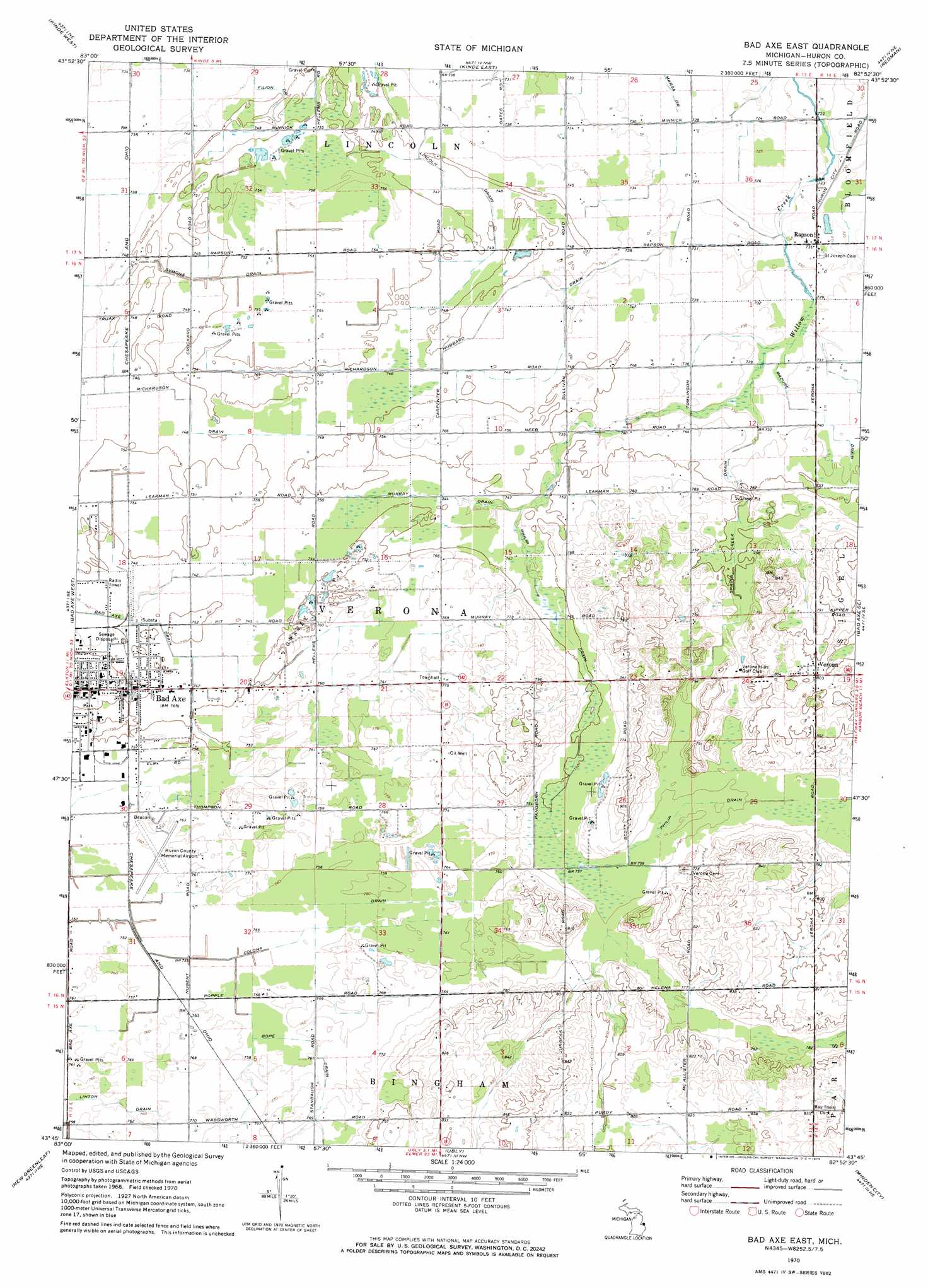
Bad Axe East Topo Map Michigan
To zoom in, hover over the map of Bad Axe East
USGS Topo Quad 43082g8 - 1:24,000 scale
| Topo Map Name: | Bad Axe East |
| USGS Topo Quad ID: | 43082g8 |
| Print Size: | ca. 21 1/4" wide x 27" high |
| Southeast Coordinates: | 43.75° N latitude / 82.875° W longitude |
| Map Center Coordinates: | 43.8125° N latitude / 82.9375° W longitude |
| U.S. State: | MI |
| Filename: | o43082g8.jpg |
| Download Map JPG Image: | Bad Axe East topo map 1:24,000 scale |
| Map Type: | Topographic |
| Topo Series: | 7.5´ |
| Map Scale: | 1:24,000 |
| Source of Map Images: | United States Geological Survey (USGS) |
| Alternate Map Versions: |
Bad Axe East MI 1970, updated 1973 Download PDF Buy paper map Bad Axe East MI 2011 Download PDF Buy paper map Bad Axe East MI 2014 Download PDF Buy paper map Bad Axe East MI 2016 Download PDF Buy paper map |
1:24,000 Topo Quads surrounding Bad Axe East
Port Austin West |
Port Austin East |
Huron City |
||
Rush Lake |
Kinde West |
Kinde East |
Redman |
Port Hope |
Elkton |
Bad Axe West |
Bad Axe East |
Bad Axe Se |
Harbor Beach |
Gagetown |
New Greenleaf |
Ubly |
Minden City |
Ruth |
Cass City |
Shabbona |
Argyle |
Palms |
Deckerville |
> Back to 43082e1 at 1:100,000 scale
> Back to 43082a1 at 1:250,000 scale
> Back to U.S. Topo Maps home
Bad Axe East topo map: Gazetteer
Bad Axe East: Airports
Huron County Memorial Airport elevation 231m 757′Bad Axe East: Canals
Bope Drain elevation 234m 767′Hubbard Drain elevation 225m 738′
Linton Drain elevation 231m 757′
Mazure Drain elevation 224m 734′
Murray Drain elevation 227m 744′
Philip Drain elevation 228m 748′
Richardson Drain elevation 225m 738′
Spring Creek Drain elevation 227m 744′
Symons Drain elevation 228m 748′
Bad Axe East: Parks
Bad Axe City Park elevation 229m 751′Wilcox Park elevation 226m 741′
Bad Axe East: Populated Places
Country Meadow Mobile Home Park elevation 228m 748′Rapson elevation 222m 728′
Verona elevation 245m 803′
Bad Axe East: Post Offices
Bad Axe Post Office elevation 233m 764′Rapson Post Office (historical) elevation 222m 728′
Verona Mills Post Office (historical) elevation 245m 803′
Wadsworth Post Office (historical) elevation 235m 770′
Bad Axe East digital topo map on disk
Buy this Bad Axe East topo map showing relief, roads, GPS coordinates and other geographical features, as a high-resolution digital map file on DVD:
 map DVD")