Lapeer Topo Map Michigan
To zoom in, hover over the map of Lapeer
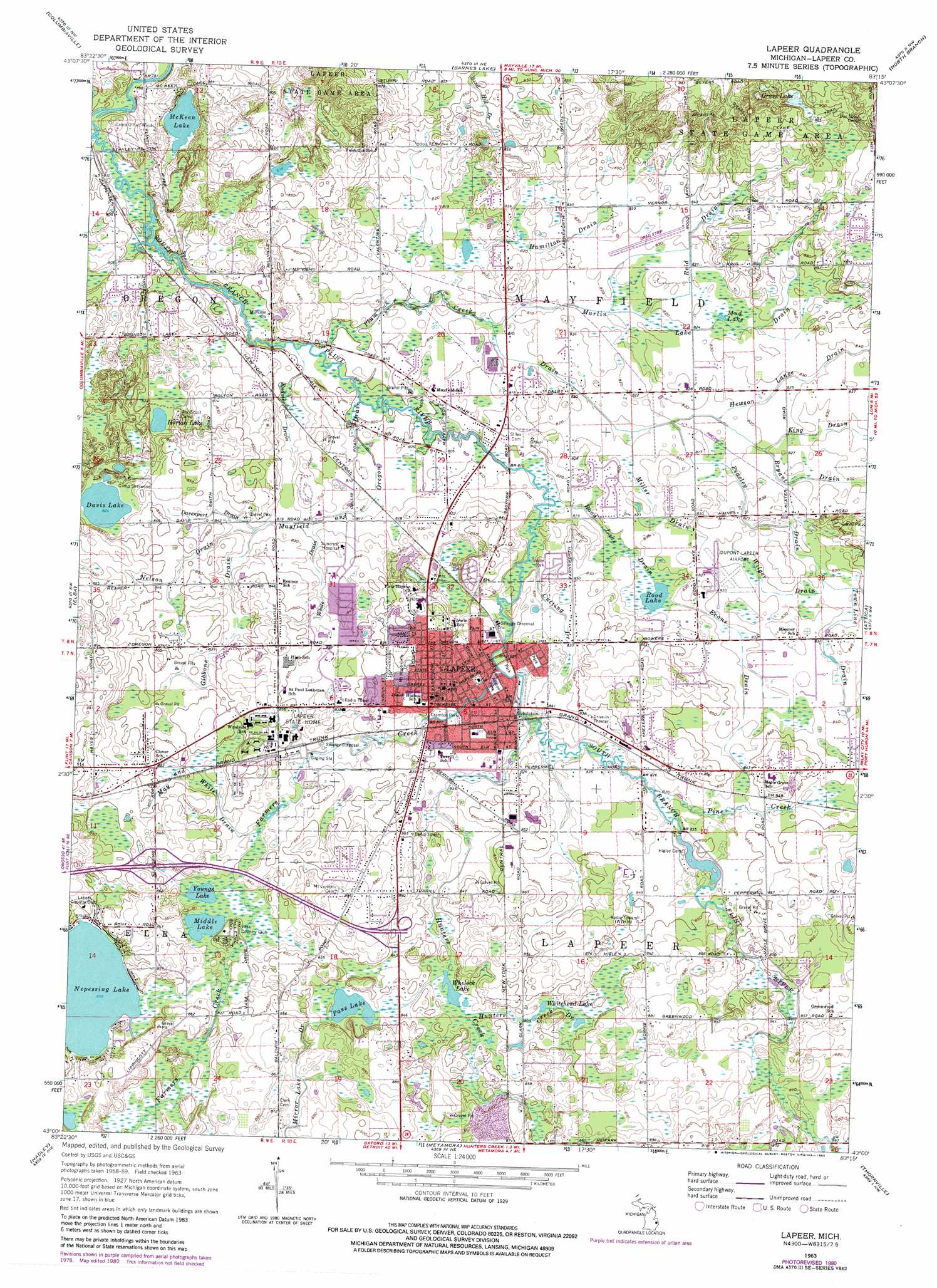
USGS Topo Quad 43083a3 - 1:24,000 scale
| Topo Map Name: | Lapeer |
| USGS Topo Quad ID: | 43083a3 |
| Print Size: | ca. 21 1/4" wide x 27" high |
| Southeast Coordinates: | 43° N latitude / 83.25° W longitude |
| Map Center Coordinates: | 43.0625° N latitude / 83.3125° W longitude |
| U.S. State: | MI |
| Filename: | o43083a3.jpg |
| Download Map JPG Image: | Lapeer topo map 1:24,000 scale |
| Map Type: | Topographic |
| Topo Series: | 7.5´ |
| Map Scale: | 1:24,000 |
| Source of Map Images: | United States Geological Survey (USGS) |
| Alternate Map Versions: |
Lapeer MI 1963, updated 1964 Download PDF Buy paper map Lapeer MI 1963, updated 1980 Download PDF Buy paper map Lapeer MI 2011 Download PDF Buy paper map Lapeer MI 2014 Download PDF Buy paper map Lapeer MI 2016 Download PDF Buy paper map |
1:24,000 Topo Quads surrounding Lapeer
Vassar |
Juniata |
Mayville |
Clifford |
Marlette |
Otisville |
Columbiaville |
Barnes Lake |
North Branch |
Burnside |
Davison |
Elba |
Lapeer |
Attica |
Imlay City |
Goodrich |
Hadley |
Metamora |
Thornville |
Almont |
Davisburg |
Ortonville |
Oxford |
Lake Orion |
Romeo |
> Back to 43083a1 at 1:100,000 scale
> Back to 43082a1 at 1:250,000 scale
> Back to U.S. Topo Maps home
Lapeer topo map: Gazetteer
Lapeer: Airports
Dupont-Lapeer Airport elevation 253m 830′Lapeer: Canals
Cutting Drain elevation 250m 820′Davenport Drain elevation 253m 830′
Evans Drain elevation 253m 830′
Gibbons Drain elevation 255m 836′
Hamilton Drain elevation 250m 820′
Hewson Lanoe Drain elevation 253m 830′
Hunters Creek Drain elevation 256m 839′
King Drain elevation 251m 823′
May and White Drain elevation 256m 839′
Mayfield and Oregon Drain elevation 247m 810′
Miller Drain elevation 250m 820′
Murlin Lake Drain elevation 250m 820′
Nelson Drain elevation 256m 839′
Peasley Drain elevation 253m 830′
Plum Creek Drain elevation 244m 800′
Reid Drain elevation 253m 830′
Rood Lake Drain elevation 250m 820′
Rudner Drain elevation 244m 800′
Town Line Drain elevation 253m 830′
White Drain elevation 253m 830′
Wilger Drain elevation 253m 830′
Lapeer: Crossings
Interchange 153 elevation 256m 839′Interchange 155 elevation 259m 849′
Lapeer: Lakes
Davis Lake elevation 251m 823′Grass Lake elevation 268m 879′
Horton Lake elevation 248m 813′
McKeen Lake elevation 243m 797′
Middle Lake elevation 252m 826′
Mud Lake elevation 251m 823′
Nepessing Lake elevation 253m 830′
Pass Lake elevation 255m 836′
Rood Lake elevation 250m 820′
Whelock Lake elevation 254m 833′
Whitehead Lake elevation 255m 836′
Youngs Lake elevation 251m 823′
Lapeer: Parks
Anrook Park elevation 247m 810′Audubon Park elevation 255m 836′
Cramton Park elevation 250m 820′
East Anrook Park elevation 247m 810′
Lapeer County Historical Marker elevation 253m 830′
Lapeer Public Library Historical Marker elevation 251m 823′
Liberty Park elevation 254m 833′
Rotary Park elevation 247m 810′
Tuttle House Historical Marker elevation 260m 853′
Lapeer: Populated Places
Chateau Pines Lake Mobile Home Park elevation 248m 813′Crestview Manor Mobile Home Park elevation 258m 846′
Hunters Creek Mobile Home Community elevation 259m 849′
Lapeer elevation 262m 859′
Lapeer Meadows Mobile Home Park elevation 251m 823′
Watertower Travel Trailer Park elevation 253m 830′
Lapeer: Post Offices
Lapeer Post Office elevation 255m 836′Oregon Post Office (historical) elevation 242m 793′
Lapeer: Streams
Farmers Creek elevation 247m 810′Hunters Creek elevation 247m 810′
Pine Creek elevation 250m 820′
Lapeer: Trails
Grass Lake Trail elevation 271m 889′Lapeer digital topo map on disk
Buy this Lapeer topo map showing relief, roads, GPS coordinates and other geographical features, as a high-resolution digital map file on DVD:
 map DVD")