Flint North Topo Map Michigan
To zoom in, hover over the map of Flint North
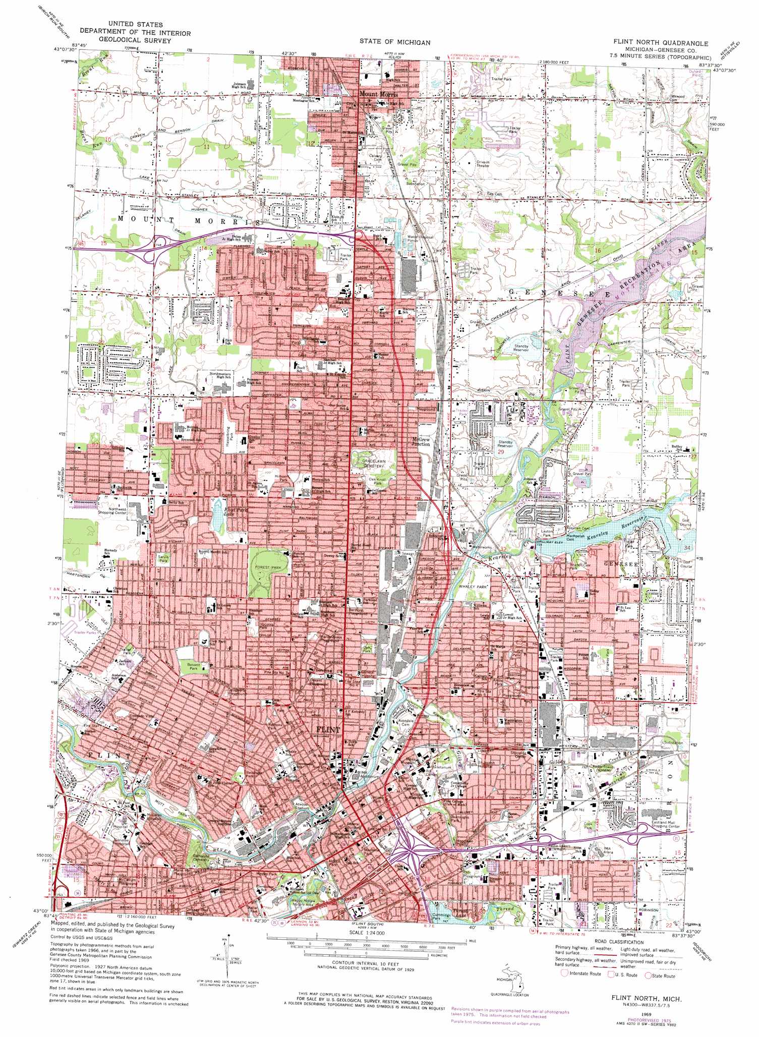
USGS Topo Quad 43083a6 - 1:24,000 scale
| Topo Map Name: | Flint North |
| USGS Topo Quad ID: | 43083a6 |
| Print Size: | ca. 21 1/4" wide x 27" high |
| Southeast Coordinates: | 43° N latitude / 83.625° W longitude |
| Map Center Coordinates: | 43.0625° N latitude / 83.6875° W longitude |
| U.S. State: | MI |
| Filename: | o43083a6.jpg |
| Download Map JPG Image: | Flint North topo map 1:24,000 scale |
| Map Type: | Topographic |
| Topo Series: | 7.5´ |
| Map Scale: | 1:24,000 |
| Source of Map Images: | United States Geological Survey (USGS) |
| Alternate Map Versions: |
Flint North MI 1969, updated 1971 Download PDF Buy paper map Flint North MI 1969, updated 1976 Download PDF Buy paper map Flint North MI 2011 Download PDF Buy paper map Flint North MI 2014 Download PDF Buy paper map Flint North MI 2017 Download PDF Buy paper map |
1:24,000 Topo Quads surrounding Flint North
Bridgeport |
Birch Run North |
Frankenmuth |
Vassar |
Juniata |
Montrose |
Birch Run South |
Clio |
Otisville |
Columbiaville |
New Lothrop |
Flushing |
Flint North |
Davison |
Elba |
Durand |
Swartz Creek |
Flint South |
Goodrich |
Hadley |
Byron |
Linden |
Fenton |
Davisburg |
Ortonville |
> Back to 43083a1 at 1:100,000 scale
> Back to 43082a1 at 1:250,000 scale
> Back to U.S. Topo Maps home
Flint North topo map: Gazetteer
Flint North: Airports
Flow Through Terminal Heliport elevation 228m 748′Flint North: Canals
Carpenter Drain elevation 228m 748′Cornwell Drain elevation 225m 738′
Craven and Benson Drain elevation 226m 741′
Delaney Drain elevation 227m 744′
Hughes Drain elevation 228m 748′
Lake Drain elevation 228m 748′
Riskin Drain elevation 223m 731′
Saxton Drain elevation 231m 757′
Flint North: Crossings
Interchange 10 elevation 232m 761′Interchange 118 elevation 235m 770′
Interchange 13 elevation 234m 767′
Interchange 136 elevation 229m 751′
Interchange 137 elevation 230m 754′
Interchange 138 elevation 229m 751′
Interchange 139 elevation 233m 764′
Interchange 15 elevation 229m 751′
Interchange 6 elevation 229m 751′
Interchange 7 elevation 226m 741′
Interchange 8A elevation 225m 738′
Interchange 8B elevation 221m 725′
Interchange 9 elevation 228m 748′
Flint North: Lakes
Flint Park Lake elevation 233m 764′Flint North: Parks
Aldrich Park elevation 216m 708′Amos Park elevation 228m 748′
Atwood Stadium elevation 218m 715′
Ballenger Park elevation 228m 748′
Bassett Park elevation 235m 770′
Beechwood Park elevation 228m 748′
Berston Field House and Playground Historical Marker elevation 232m 761′
Branch-Carr Park elevation 227m 744′
Brennan Park elevation 231m 757′
Buick Motor Company Historical Marker (historical) elevation 224m 734′
Burroughs Park elevation 224m 734′
Charles W Nash Historical Marker elevation 216m 708′
Civic Park Historic District Historical Marker elevation 236m 774′
Community Presbyterian Church Historical Marker elevation 238m 780′
Cook Park elevation 231m 757′
Court Street United Methodist Church Historical Marker elevation 229m 751′
Crossroads Village and Huckleberry Railroad elevation 223m 731′
Dayton Park elevation 217m 711′
Dewey Park elevation 244m 800′
Durant-Dort Carriage Company Historical Marker elevation 217m 711′
Durant-Dort Carriage Factory Number One Historical Marker elevation 216m 708′
Eldorado Vista Park elevation 235m 770′
Fleming Park elevation 235m 770′
Flint Road Cart Factory Historical Marker elevation 216m 708′
Flint Sit-Down Historical Marker elevation 218m 715′
Flint Sit-Down Historical Marker elevation 214m 702′
Forest Park elevation 238m 780′
Fred A Aldrich Historical Marker elevation 218m 715′
Genesee County Courthouse Historical Marker elevation 230m 754′
Glenwood Cemetery Historical Marker elevation 231m 757′
Happy Hollow Nature Area elevation 217m 711′
Hasselbring Park elevation 233m 764′
Henry Howland Crapo Historical Marker elevation 223m 731′
Hilborn Park elevation 240m 787′
Iroquois Park elevation 235m 770′
Jacob Smith Historical Marker elevation 218m 715′
Kearsley Park elevation 217m 711′
Kellar Park elevation 228m 748′
Layton Park elevation 226m 741′
Longway Park elevation 231m 757′
McFarlan Park elevation 219m 718′
Memorial Park elevation 232m 761′
Michigan School for the Deaf Historical Marker elevation 232m 761′
Mosley Park elevation 230m 754′
Mott Park elevation 213m 698′
Oak Park elevation 228m 748′
Ophelia Bonner Park elevation 236m 774′
Quinn Chapel African Methodist Episcopal Church Historical Marker elevation 232m 761′
Ramona Park elevation 238m 780′
Riverside Park elevation 222m 728′
Robert J Whaley Historical Marker elevation 226m 741′
Saint Michael Roman Catholic Church Historical Marker elevation 225m 738′
Saint Paul's Episcopal Church Historical Marker elevation 226m 741′
Sarah Emma Edmonds Historical Marker elevation 229m 751′
Sarvis Park elevation 235m 770′
Stepping Stone Falls and Picnic Area elevation 230m 754′
Superintendent's Cottage Historical Marker elevation 232m 761′
The Vehicle City Historical Marker elevation 229m 751′
Up River Parkway elevation 219m 718′
Vietnam Veterans Park elevation 216m 708′
Voiture 1116 40 et 8 Historical Marker elevation 235m 770′
Whaley House Historical Marker elevation 226m 741′
Whaley Park elevation 220m 721′
William C Durant Historical Marker elevation 217m 711′
Willson Park Historical Marker elevation 223m 731′
Wilson Park elevation 222m 728′
Woodlawn Park elevation 224m 734′
Flint North: Populated Places
American Mobile Home Park elevation 230m 754′Beecher elevation 245m 803′
Carriage Hills Mobile Home Park elevation 229m 751′
Carriage Manor Mobile Home Park elevation 233m 764′
Diane Mobile Home Manor elevation 233m 764′
Dutch Village Mobile Home Park elevation 241m 790′
Flint elevation 229m 751′
Gunther Mobile Home Court elevation 242m 793′
Highlands Mobile Home Park elevation 247m 810′
Holiday Village Mobile Home Park elevation 229m 751′
Holt's Mobile Home Court elevation 230m 754′
Kearsley Lake Terrace Mobile Home Park elevation 226m 741′
Kirkwood Community Mobile Home Park elevation 231m 757′
Lakeside Mobile Court elevation 227m 744′
McGrew Junction elevation 230m 754′
Mount Morris elevation 235m 770′
Myrtle Grove Mobile Home Park elevation 235m 770′
Pasadena Mobile Home Park elevation 234m 767′
Richfield Mobile Home Park elevation 230m 754′
Shady Acres Mobile Home Park elevation 222m 728′
Twilight Mobile Home Park elevation 234m 767′
Westwood Village Mobile Home Park elevation 234m 767′
Flint North: Post Offices
Flint Post Office elevation 219m 718′Flint River Junction Post Office (historical) elevation 232m 761′
Mount Morris Post Office elevation 238m 780′
Flint North: Reservoirs
C S Mott Lake elevation 222m 728′Kearsley Reservoir elevation 224m 734′
Flint North: Streams
Chipmunk Creek elevation 225m 738′Gilkey Creek elevation 216m 708′
Kearsley Creek elevation 218m 715′
Swartz Creek elevation 214m 702′
Thread Creek elevation 217m 711′
Flint North digital topo map on disk
Buy this Flint North topo map showing relief, roads, GPS coordinates and other geographical features, as a high-resolution digital map file on DVD:
 map DVD")