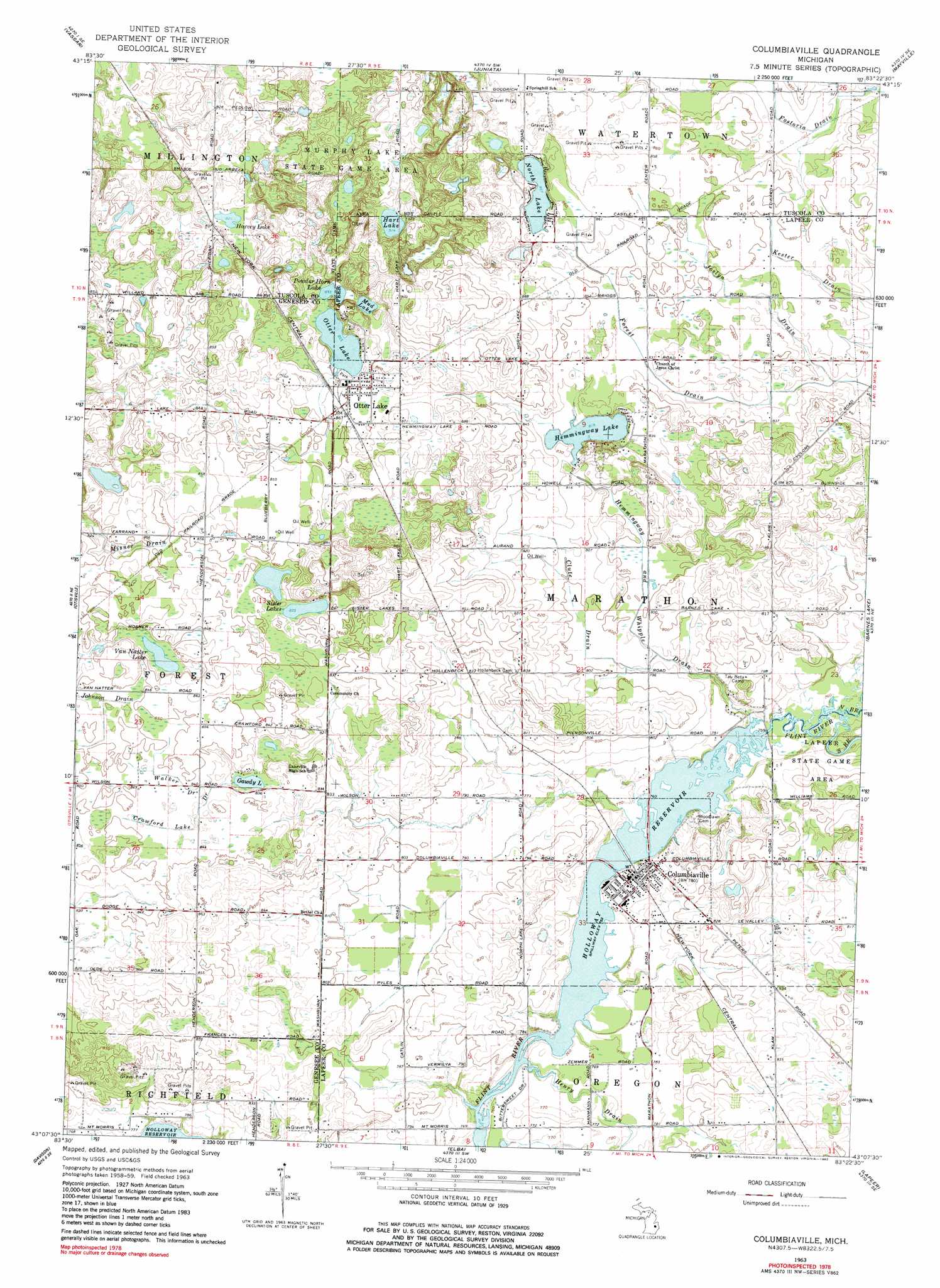
Columbiaville Topo Map Michigan
To zoom in, hover over the map of Columbiaville
USGS Topo Quad 43083b4 - 1:24,000 scale
| Topo Map Name: | Columbiaville |
| USGS Topo Quad ID: | 43083b4 |
| Print Size: | ca. 21 1/4" wide x 27" high |
| Southeast Coordinates: | 43.125° N latitude / 83.375° W longitude |
| Map Center Coordinates: | 43.1875° N latitude / 83.4375° W longitude |
| U.S. State: | MI |
| Filename: | o43083b4.jpg |
| Download Map JPG Image: | Columbiaville topo map 1:24,000 scale |
| Map Type: | Topographic |
| Topo Series: | 7.5´ |
| Map Scale: | 1:24,000 |
| Source of Map Images: | United States Geological Survey (USGS) |
| Alternate Map Versions: |
Columbiaville MI 1963, updated 1964 Download PDF Buy paper map Columbiaville MI 1963, updated 1982 Download PDF Buy paper map Columbiaville MI 2011 Download PDF Buy paper map Columbiaville MI 2014 Download PDF Buy paper map Columbiaville MI 2017 Download PDF Buy paper map |
1:24,000 Topo Quads surrounding Columbiaville
Reese |
Gilford |
Caro |
East Dayton |
Kingston |
Frankenmuth |
Vassar |
Juniata |
Mayville |
Clifford |
Clio |
Otisville |
Columbiaville |
Barnes Lake |
North Branch |
Flint North |
Davison |
Elba |
Lapeer |
Attica |
Flint South |
Goodrich |
Hadley |
Metamora |
Thornville |
> Back to 43083a1 at 1:100,000 scale
> Back to 43082a1 at 1:250,000 scale
> Back to U.S. Topo Maps home
Columbiaville topo map: Gazetteer
Columbiaville: Canals
Crawford Lake Drain elevation 256m 839′Johnson Drain elevation 256m 839′
Walker Drain elevation 256m 839′
Columbiaville: Lakes
Gawdy Lake elevation 252m 826′Hart Lake elevation 278m 912′
Harvey Lake elevation 250m 820′
Hemmingway Lake elevation 249m 816′
Mud Lake elevation 261m 856′
North Lake elevation 261m 856′
Otter Lake elevation 260m 853′
Powder Horn Lake elevation 260m 853′
Sister Lakes elevation 255m 836′
Van Natter Lake elevation 255m 836′
Columbiaville: Parks
Columbiaville Depot Historical Marker elevation 237m 777′Otter Lake Park elevation 262m 859′
United Methodist Church Historical Marker elevation 236m 774′
William Peter Mansion Historical Marker elevation 235m 770′
Columbiaville: Populated Places
Columbiaville elevation 235m 770′Davison Hills Mobile Home Park elevation 235m 770′
Otter Lake elevation 265m 869′
Columbiaville: Post Offices
Columbiaville Post Office elevation 234m 767′Marathon Post Office (historical) elevation 237m 777′
Otter Lake Post Office elevation 263m 862′
Columbiaville: Reservoirs
Lake Henson elevation 265m 869′Columbiaville: Streams
Clute Drain elevation 237m 777′Hemmingway and Whipple Drain elevation 230m 754′
Henry Drain elevation 229m 751′
Joslyn Drain elevation 250m 820′
North Branch Flint River elevation 231m 757′
South Branch Flint River elevation 231m 757′
Columbiaville digital topo map on disk
Buy this Columbiaville topo map showing relief, roads, GPS coordinates and other geographical features, as a high-resolution digital map file on DVD:
 map DVD")