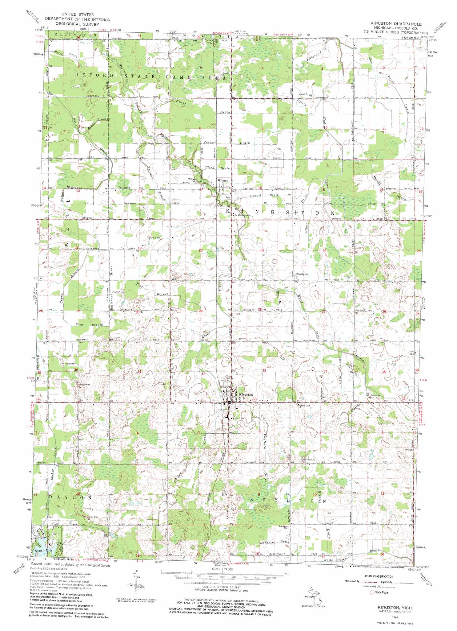
Kingston Topo Map Michigan
To zoom in, hover over the map of Kingston
USGS Topo Quad 43083d2 - 1:24,000 scale
| Topo Map Name: | Kingston |
| USGS Topo Quad ID: | 43083d2 |
| Print Size: | ca. 21 1/4" wide x 27" high |
| Southeast Coordinates: | 43.375° N latitude / 83.125° W longitude |
| Map Center Coordinates: | 43.4375° N latitude / 83.1875° W longitude |
| U.S. State: | MI |
| Filename: | o43083d2.jpg |
| Download Map JPG Image: | Kingston topo map 1:24,000 scale |
| Map Type: | Topographic |
| Topo Series: | 7.5´ |
| Map Scale: | 1:24,000 |
| Source of Map Images: | United States Geological Survey (USGS) |
| Alternate Map Versions: |
Kingston MI 1963, updated 1964 Download PDF Buy paper map Kingston MI 1963, updated 1983 Download PDF Buy paper map Kingston MI 2011 Download PDF Buy paper map Kingston MI 2014 Download PDF Buy paper map Kingston MI 2016 Download PDF Buy paper map |
1:24,000 Topo Quads surrounding Kingston
Sebewaing |
Owendale |
Gagetown |
New Greenleaf |
Ubly |
Colling |
Ellington |
Cass City |
Shabbona |
Argyle |
Caro |
East Dayton |
Kingston |
Decker |
Snover |
Juniata |
Mayville |
Clifford |
Marlette |
Juhl |
Columbiaville |
Barnes Lake |
North Branch |
Burnside |
Brown City |
> Back to 43083a1 at 1:100,000 scale
> Back to 43082a1 at 1:250,000 scale
> Back to U.S. Topo Maps home
Kingston topo map: Gazetteer
Kingston: Canals
Clark Drain elevation 233m 764′Curry Branch elevation 232m 761′
Elliott Drain elevation 235m 770′
Evans Drain elevation 232m 761′
Jeffery Drain elevation 234m 767′
McKenzie Drain elevation 250m 820′
Michler Drain elevation 247m 810′
Mud Creek Drain elevation 232m 761′
Ohr Drain elevation 234m 767′
Retherford Drain elevation 231m 757′
Richter Drain elevation 238m 780′
Snover Drain elevation 232m 761′
Stewart Drain elevation 236m 774′
Sucker Creek Drain elevation 238m 780′
Tallman Drain elevation 231m 757′
Taylor Branch elevation 235m 770′
Tong Branch elevation 234m 767′
Vanhorn Drain elevation 247m 810′
Wallace Branch elevation 228m 748′
White Creek Drain elevation 238m 780′
Wilson Drain elevation 235m 770′
Zemke Branch elevation 228m 748′
Kingston: Lakes
Shay Lake elevation 236m 774′Kingston: Populated Places
Kingston elevation 245m 803′Wilmot elevation 234m 767′
Kingston: Post Offices
Kingston Post Office elevation 241m 790′Wilmont Post Office (historical) elevation 233m 764′
Kingston: Streams
Alder Creek elevation 231m 757′Spring Creek elevation 238m 780′
Kingston digital topo map on disk
Buy this Kingston topo map showing relief, roads, GPS coordinates and other geographical features, as a high-resolution digital map file on DVD:
 map DVD")