Gilford Topo Map Michigan
To zoom in, hover over the map of Gilford
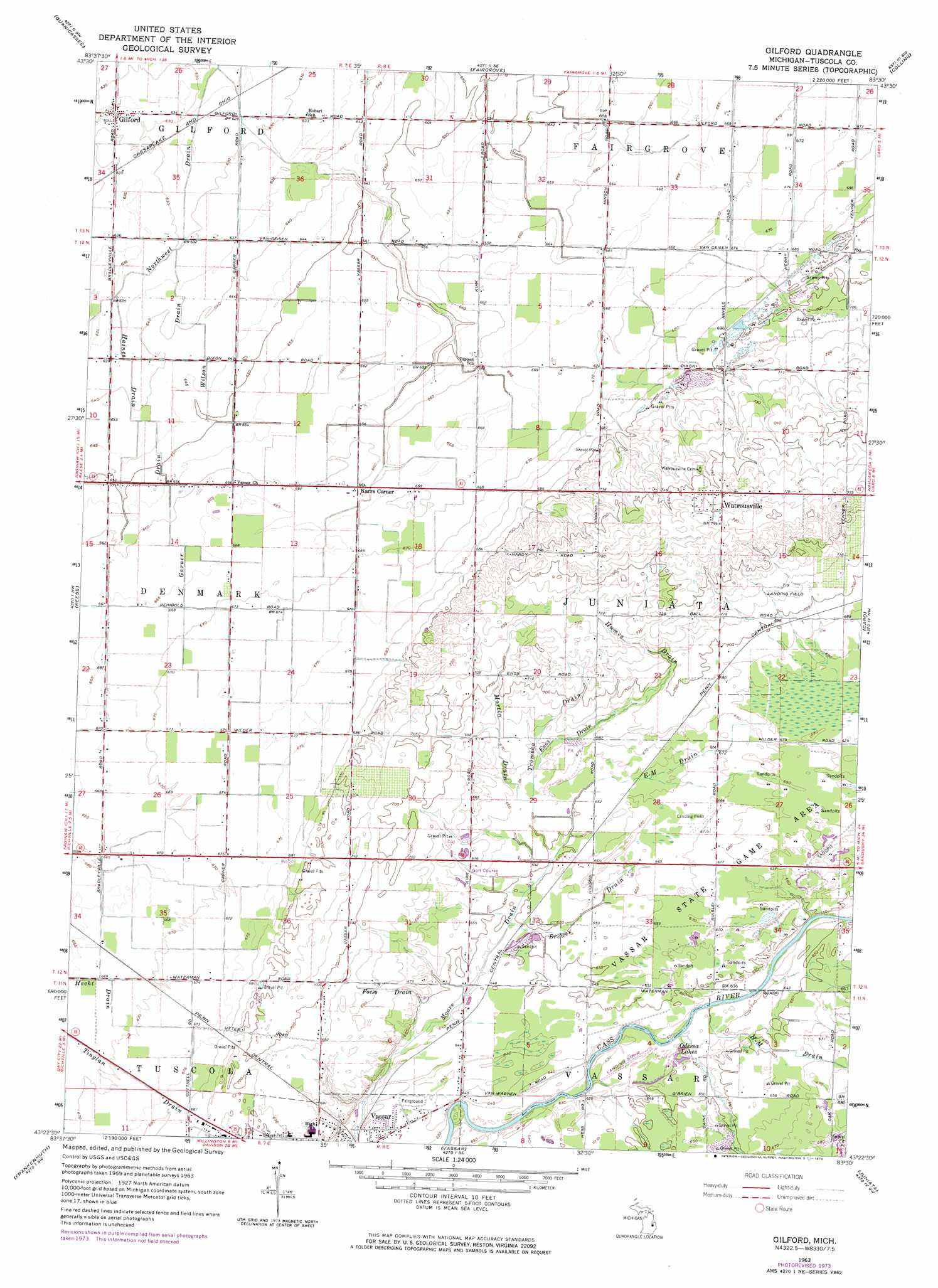
USGS Topo Quad 43083d5 - 1:24,000 scale
| Topo Map Name: | Gilford |
| USGS Topo Quad ID: | 43083d5 |
| Print Size: | ca. 21 1/4" wide x 27" high |
| Southeast Coordinates: | 43.375° N latitude / 83.5° W longitude |
| Map Center Coordinates: | 43.4375° N latitude / 83.5625° W longitude |
| U.S. State: | MI |
| Filename: | o43083d5.jpg |
| Download Map JPG Image: | Gilford topo map 1:24,000 scale |
| Map Type: | Topographic |
| Topo Series: | 7.5´ |
| Map Scale: | 1:24,000 |
| Source of Map Images: | United States Geological Survey (USGS) |
| Alternate Map Versions: |
Gilford MI 1963, updated 1964 Download PDF Buy paper map Gilford MI 1963, updated 1974 Download PDF Buy paper map Gilford MI 2011 Download PDF Buy paper map Gilford MI 2014 Download PDF Buy paper map Gilford MI 2017 Download PDF Buy paper map |
1:24,000 Topo Quads surrounding Gilford
Bay City Ne |
Fish Point |
Sebewaing |
Owendale |
|
Essexville |
Quanicassee |
Fairgrove |
Colling |
Ellington |
Saginaw Ne |
Reese |
Gilford |
Caro |
East Dayton |
Birch Run North |
Frankenmuth |
Vassar |
Juniata |
Mayville |
Birch Run South |
Clio |
Otisville |
Columbiaville |
Barnes Lake |
> Back to 43083a1 at 1:100,000 scale
> Back to 43082a1 at 1:250,000 scale
> Back to U.S. Topo Maps home
Gilford topo map: Gazetteer
Gilford: Canals
Brewer Drain elevation 198m 649′E-M Drain elevation 201m 659′
Enos Drain elevation 204m 669′
Foess Drain elevation 207m 679′
Garner Drain elevation 200m 656′
Haines Drain elevation 192m 629′
Humes Drain elevation 217m 711′
Martin Drain elevation 204m 669′
Northwest Drain elevation 189m 620′
Trombka Drain elevation 204m 669′
Wilson Drain elevation 195m 639′
Gilford: Lakes
Odessa Lakes elevation 194m 636′Gilford: Parks
Gilford United Methodist Church Historical Marker elevation 195m 639′Vassar State Game Area elevation 205m 672′
Watrous General Store Historical Marker elevation 231m 757′
Watrousville United Methodist Church Historical Marker elevation 235m 770′
Gilford: Populated Places
Gilford elevation 194m 636′Karrs Corner elevation 201m 659′
Watrousville elevation 231m 757′
Gilford: Post Offices
Crossman Post Office (historical) elevation 210m 688′Denmark Post Office (historical) elevation 201m 659′
Gilford Post Office elevation 194m 636′
Watrousville Post Office (historical) elevation 231m 757′
Gilford: Streams
H-M Drain elevation 192m 629′Gilford digital topo map on disk
Buy this Gilford topo map showing relief, roads, GPS coordinates and other geographical features, as a high-resolution digital map file on DVD:
 map DVD")