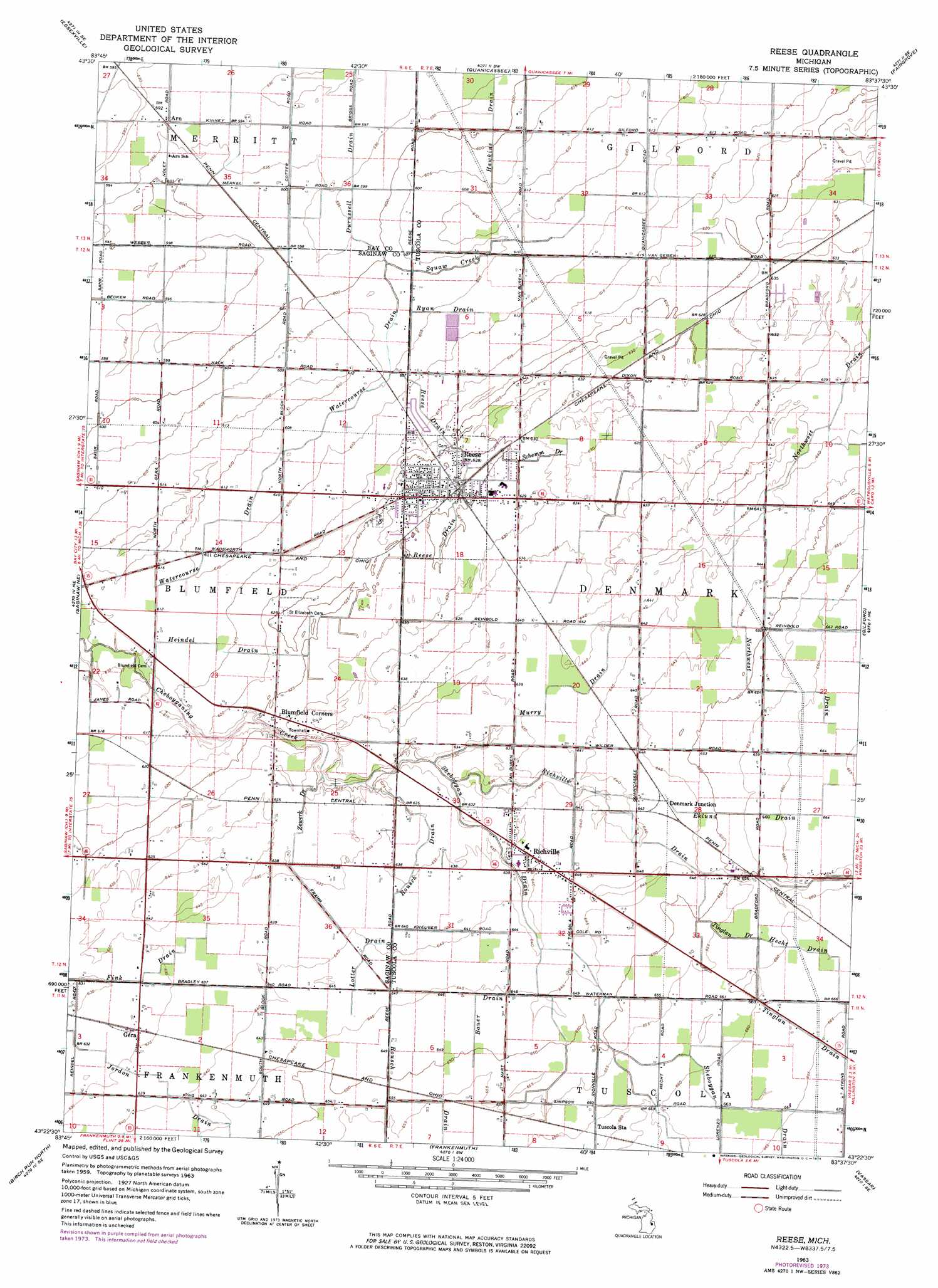
Reese Topo Map Michigan
To zoom in, hover over the map of Reese
USGS Topo Quad 43083d6 - 1:24,000 scale
| Topo Map Name: | Reese |
| USGS Topo Quad ID: | 43083d6 |
| Print Size: | ca. 21 1/4" wide x 27" high |
| Southeast Coordinates: | 43.375° N latitude / 83.625° W longitude |
| Map Center Coordinates: | 43.4375° N latitude / 83.6875° W longitude |
| U.S. State: | MI |
| Filename: | o43083d6.jpg |
| Download Map JPG Image: | Reese topo map 1:24,000 scale |
| Map Type: | Topographic |
| Topo Series: | 7.5´ |
| Map Scale: | 1:24,000 |
| Source of Map Images: | United States Geological Survey (USGS) |
| Alternate Map Versions: |
Reese MI 1963, updated 1964 Download PDF Buy paper map Reese MI 1963, updated 1974 Download PDF Buy paper map Reese MI 2011 Download PDF Buy paper map Reese MI 2014 Download PDF Buy paper map Reese MI 2017 Download PDF Buy paper map |
1:24,000 Topo Quads surrounding Reese
Kawkawlin |
Bay City Ne |
Fish Point |
Sebewaing |
|
Bay City |
Essexville |
Quanicassee |
Fairgrove |
Colling |
Saginaw |
Saginaw Ne |
Reese |
Gilford |
Caro |
Bridgeport |
Birch Run North |
Frankenmuth |
Vassar |
Juniata |
Montrose |
Birch Run South |
Clio |
Otisville |
Columbiaville |
> Back to 43083a1 at 1:100,000 scale
> Back to 43082a1 at 1:250,000 scale
> Back to U.S. Topo Maps home
Reese topo map: Gazetteer
Reese: Canals
Bauer Drain elevation 195m 639′Durussell Drain elevation 180m 590′
Ekund Drain elevation 198m 649′
Fink Drain elevation 191m 626′
Hawkins Drain elevation 182m 597′
Hecht Drain elevation 201m 659′
Heindel Drain elevation 186m 610′
Lotter Drain elevation 195m 639′
Murry Drain elevation 193m 633′
Reese Drain elevation 188m 616′
Richville Drain elevation 194m 636′
Rousch Drain elevation 195m 639′
Ryan Drain elevation 184m 603′
Schemn Drain elevation 190m 623′
Sheboygan Drain elevation 191m 626′
Squaw Creek elevation 182m 597′
Tinglan Drain elevation 200m 656′
Watercourse Drain elevation 184m 603′
Zewerk Drain elevation 191m 626′
Reese: Parks
Frankenhilf Historical Marker elevation 193m 633′Reese: Populated Places
Arn elevation 181m 593′Blumfield Corners elevation 191m 626′
Denmark Junction elevation 195m 639′
Gera elevation 193m 633′
Meadows Mobile Home Park elevation 187m 613′
Pebble Creek Mobile Home Community elevation 192m 629′
Reese elevation 192m 629′
Richville elevation 195m 639′
Reese: Post Offices
Arn Post Office (historical) elevation 181m 593′Gera Post Office (historical) elevation 194m 636′
Jenney Post Office (historical) elevation 194m 636′
Reese Post Office elevation 192m 629′
Richville Post Office elevation 195m 639′
Reese digital topo map on disk
Buy this Reese topo map showing relief, roads, GPS coordinates and other geographical features, as a high-resolution digital map file on DVD:
 map DVD")