Saint Johns North Topo Map Michigan
To zoom in, hover over the map of Saint Johns North
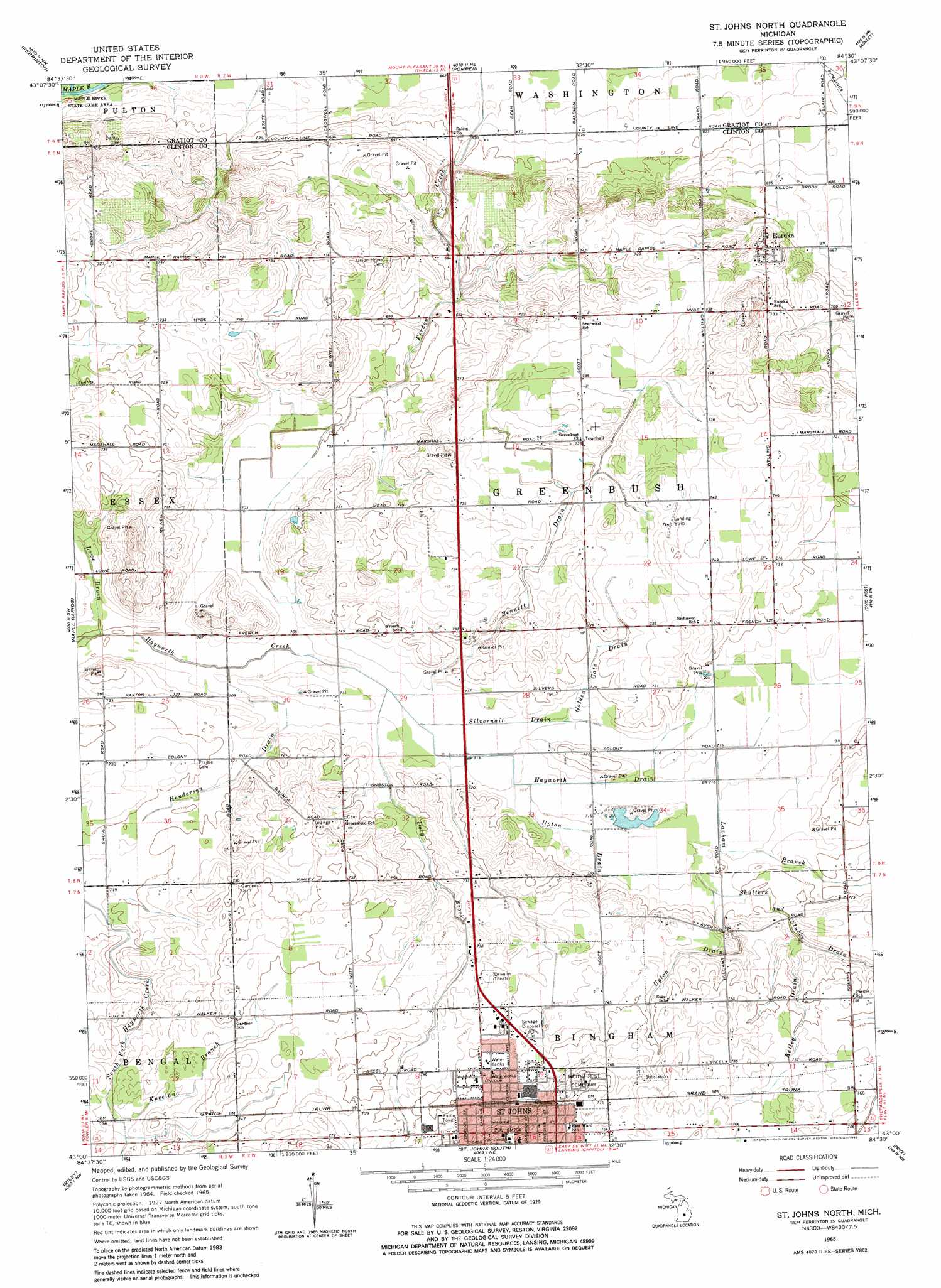
USGS Topo Quad 43084a5 - 1:24,000 scale
| Topo Map Name: | Saint Johns North |
| USGS Topo Quad ID: | 43084a5 |
| Print Size: | ca. 21 1/4" wide x 27" high |
| Southeast Coordinates: | 43° N latitude / 84.5° W longitude |
| Map Center Coordinates: | 43.0625° N latitude / 84.5625° W longitude |
| U.S. State: | MI |
| Filename: | o43084a5.jpg |
| Download Map JPG Image: | Saint Johns North topo map 1:24,000 scale |
| Map Type: | Topographic |
| Topo Series: | 7.5´ |
| Map Scale: | 1:24,000 |
| Source of Map Images: | United States Geological Survey (USGS) |
| Alternate Map Versions: |
St. Johns North MI 1965, updated 1967 Download PDF Buy paper map St. Johns North MI 1965, updated 1982 Download PDF Buy paper map Saint Johns North MI 2011 Download PDF Buy paper map Saint Johns North MI 2014 Download PDF Buy paper map Saint Johns North MI 2016 Download PDF Buy paper map |
1:24,000 Topo Quads surrounding Saint Johns North
Sumner |
Alma South |
Ithaca |
Rathbone |
Lakefield |
Carson City |
Perrinton |
Pompeii |
Ashley |
Chapin |
Hubbardston |
Maple Rapids |
Saint Johns North |
Ovid West |
Ovid East |
Wasphalia |
Riley |
Saint Johns South |
Price |
Laingsburg |
Eagle |
Wacousta |
Lansing North |
Bath |
Shaftsburg |
> Back to 43084a1 at 1:100,000 scale
> Back to 43084a1 at 1:250,000 scale
> Back to U.S. Topo Maps home
Saint Johns North topo map: Gazetteer
Saint Johns North: Airports
Glowacki Airport elevation 235m 770′Randolphs Landing Area elevation 211m 692′
Saint Johns North: Canals
Bennett Drain elevation 220m 721′Golden Gate Drain elevation 219m 718′
Hayworth Drain elevation 217m 711′
Henderson Drain elevation 218m 715′
Kelley Drain elevation 229m 751′
Lowe Drain elevation 215m 705′
Shulters and Stubbs Drain elevation 222m 728′
Silvernail Drain elevation 215m 705′
Upton Drain elevation 217m 711′
Saint Johns North: Parks
Greenbush United Methodist Church Historical Marker elevation 224m 734′Paine-Gillam-Scott House Historical Marker elevation 243m 797′
Saint John's Church Historical Marker elevation 243m 797′
Saint Johns North: Populated Places
Eureka elevation 220m 721′Saint Johns elevation 242m 793′
Saint Johns Mobile Home Village elevation 227m 744′
Saint Johns North: Post Offices
Eureka Post Office elevation 220m 721′Lyon's Mill Post Office (historical) elevation 226m 741′
Saint Johns Post Office elevation 240m 787′
Union Home Post Office (historical) elevation 224m 734′
Saint Johns North: Streams
Doty Brook elevation 215m 705′Kneeland Branch elevation 223m 731′
Lapham Branch elevation 217m 711′
Saint Johns North digital topo map on disk
Buy this Saint Johns North topo map showing relief, roads, GPS coordinates and other geographical features, as a high-resolution digital map file on DVD: