Alicia Topo Map Michigan
To zoom in, hover over the map of Alicia
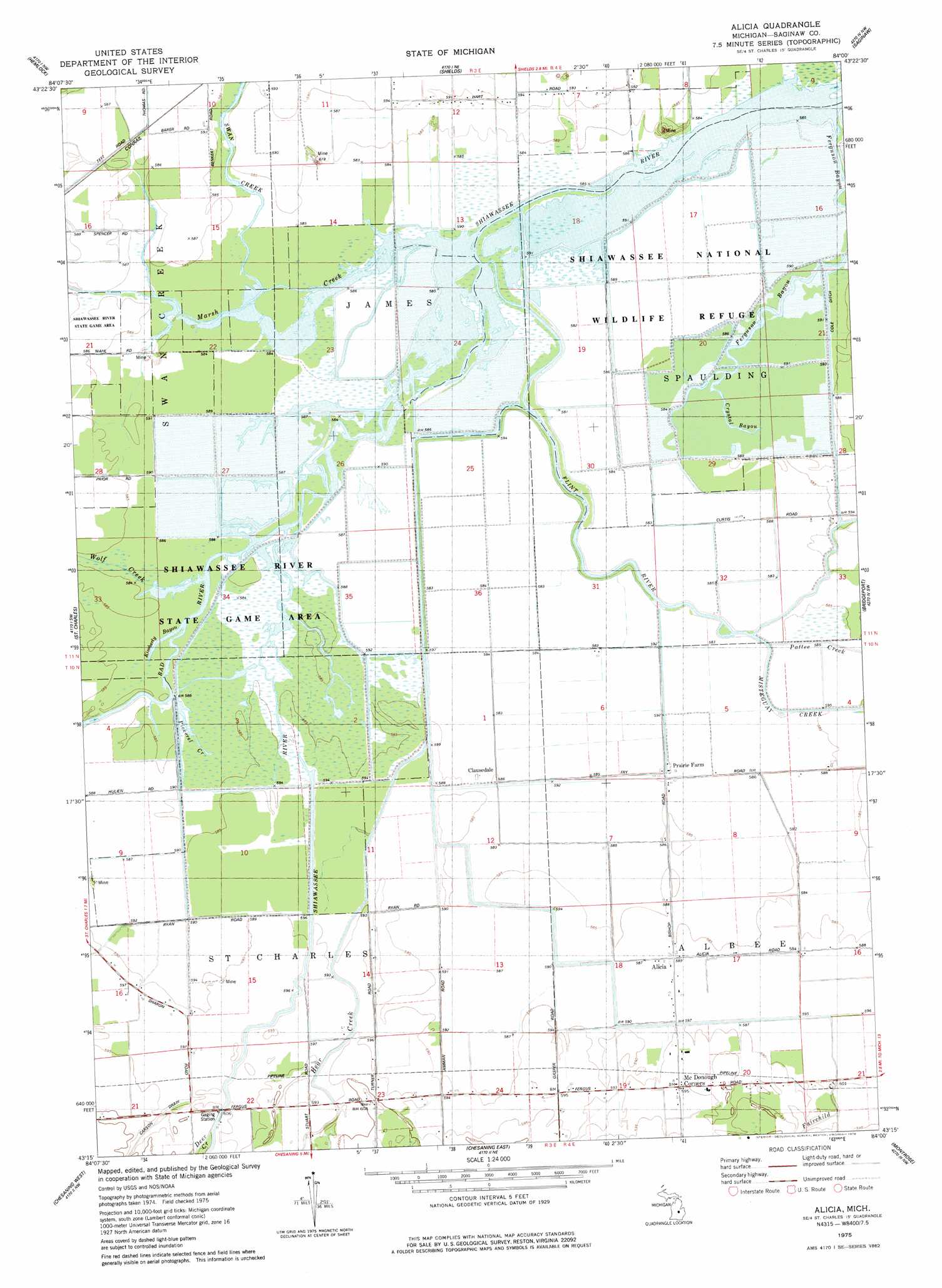
USGS Topo Quad 43084c1 - 1:24,000 scale
| Topo Map Name: | Alicia |
| USGS Topo Quad ID: | 43084c1 |
| Print Size: | ca. 21 1/4" wide x 27" high |
| Southeast Coordinates: | 43.25° N latitude / 84° W longitude |
| Map Center Coordinates: | 43.3125° N latitude / 84.0625° W longitude |
| U.S. State: | MI |
| Filename: | o43084c1.jpg |
| Download Map JPG Image: | Alicia topo map 1:24,000 scale |
| Map Type: | Topographic |
| Topo Series: | 7.5´ |
| Map Scale: | 1:24,000 |
| Source of Map Images: | United States Geological Survey (USGS) |
| Alternate Map Versions: |
Alicia MI 1975, updated 1978 Download PDF Buy paper map Alicia MI 2011 Download PDF Buy paper map Alicia MI 2014 Download PDF Buy paper map Alicia MI 2016 Download PDF Buy paper map |
1:24,000 Topo Quads surrounding Alicia
Gordonville |
Midland South |
Auburn |
Bay City |
Essexville |
Merrill |
Hemlock |
Shields |
Saginaw |
Saginaw Ne |
Lakefield |
Saint Charles |
Alicia |
Bridgeport |
Birch Run North |
Chapin |
Chesaning West |
Chesaning East |
Montrose |
Birch Run South |
Ovid East |
Owosso North |
Easton |
New Lothrop |
Flushing |
> Back to 43084a1 at 1:100,000 scale
> Back to 43084a1 at 1:250,000 scale
> Back to U.S. Topo Maps home
Alicia topo map: Gazetteer
Alicia: Canals
Cole Ditch elevation 178m 583′Alicia: Guts
Crystal Bayou elevation 178m 583′Kimberly Bayou elevation 178m 583′
Alicia: Parks
Shiawassee National Wildlife Refuge elevation 178m 583′Shiawassee River State Game Area elevation 178m 583′
Alicia: Populated Places
Alicia elevation 178m 583′Clausedale elevation 178m 583′
Alicia: Post Offices
Alicia Post Office (historical) elevation 179m 587′McDonough Post Office (historical) elevation 181m 593′
Alicia: Streams
Bad River elevation 178m 583′Bear Creek elevation 178m 583′
Carson Drain elevation 180m 590′
Deer Creek elevation 182m 597′
Fairchild Creek elevation 177m 580′
Flint River elevation 177m 580′
Marsh Creek elevation 177m 580′
Misteguay Creek elevation 178m 583′
Pattee Creek elevation 178m 583′
Pickerel Creek elevation 178m 583′
Swan Creek elevation 178m 583′
Wolf Creek elevation 178m 583′
Alicia digital topo map on disk
Buy this Alicia topo map showing relief, roads, GPS coordinates and other geographical features, as a high-resolution digital map file on DVD: