Midland South Topo Map Michigan
To zoom in, hover over the map of Midland South
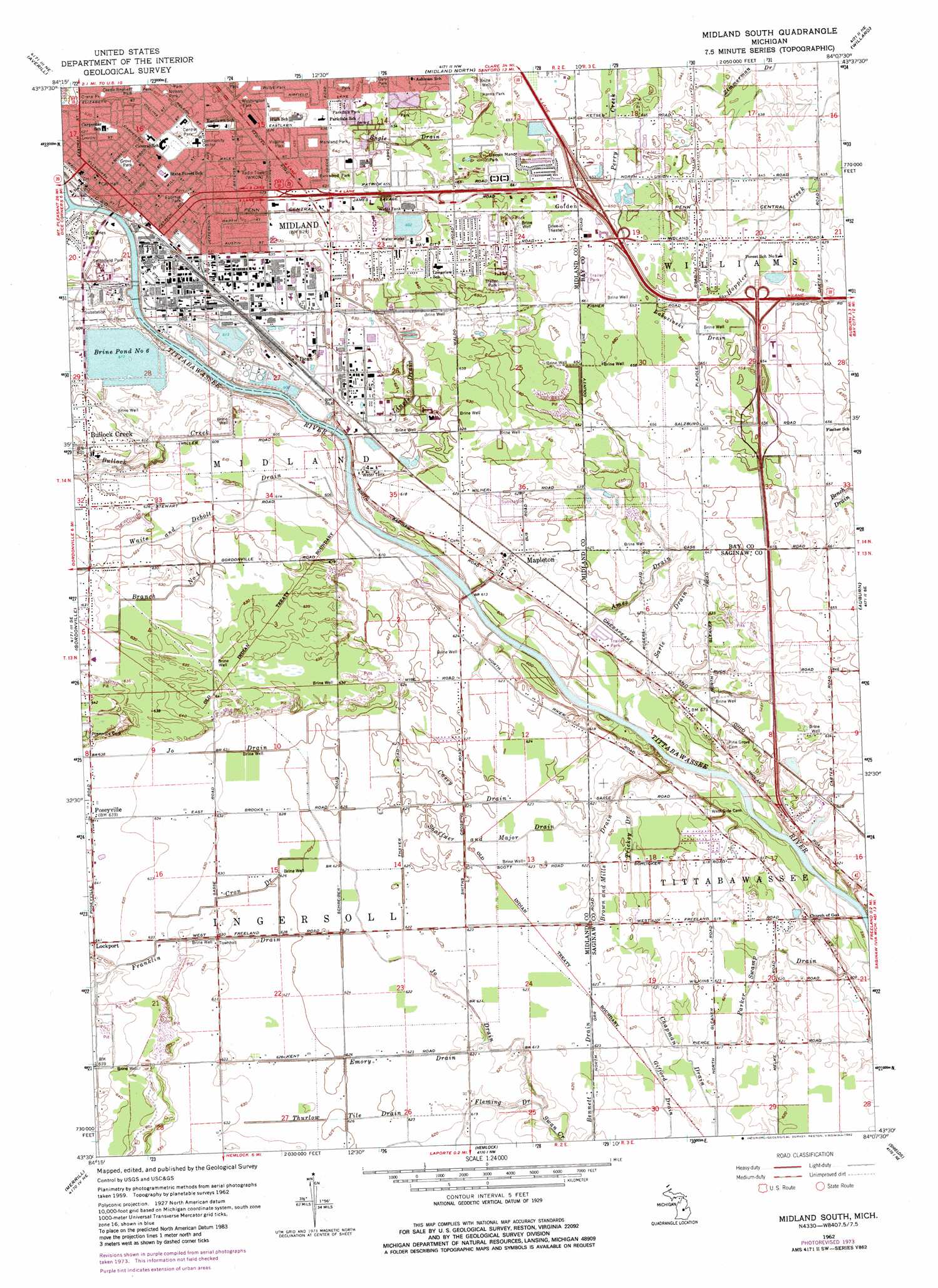
USGS Topo Quad 43084e2 - 1:24,000 scale
| Topo Map Name: | Midland South |
| USGS Topo Quad ID: | 43084e2 |
| Print Size: | ca. 21 1/4" wide x 27" high |
| Southeast Coordinates: | 43.5° N latitude / 84.125° W longitude |
| Map Center Coordinates: | 43.5625° N latitude / 84.1875° W longitude |
| U.S. State: | MI |
| Filename: | o43084e2.jpg |
| Download Map JPG Image: | Midland South topo map 1:24,000 scale |
| Map Type: | Topographic |
| Topo Series: | 7.5´ |
| Map Scale: | 1:24,000 |
| Source of Map Images: | United States Geological Survey (USGS) |
| Alternate Map Versions: |
Midland South MI 1962, updated 1964 Download PDF Buy paper map Midland South MI 1962, updated 1974 Download PDF Buy paper map Midland South MI 1962, updated 1982 Download PDF Buy paper map Midland South MI 1962, updated 1982 Download PDF Buy paper map Midland South MI 2011 Download PDF Buy paper map Midland South MI 2014 Download PDF Buy paper map Midland South MI 2016 Download PDF Buy paper map |
1:24,000 Topo Quads surrounding Midland South
Edenville |
Hope |
Estey |
Crump |
Pinconning |
Sanford |
Averill |
Midland North |
Willard |
Kawkawlin |
Floyd |
Gordonville |
Midland South |
Auburn |
Bay City |
Breckenridge |
Merrill |
Hemlock |
Shields |
Saginaw |
Rathbone |
Lakefield |
Saint Charles |
Alicia |
Bridgeport |
> Back to 43084e1 at 1:100,000 scale
> Back to 43084a1 at 1:250,000 scale
> Back to U.S. Topo Maps home
Midland South topo map: Gazetteer
Midland South: Airports
Dow Division Heliport elevation 186m 610′Pear Grove Airport elevation 195m 639′
Midland South: Canals
Ames Drain elevation 181m 593′Bennett Drain elevation 189m 620′
Branch Number One elevation 190m 623′
Brown and Mills Drain elevation 188m 616′
Casey Drain elevation 190m 623′
Cron Drain elevation 190m 623′
Emory Drain elevation 189m 620′
Engle Drain elevation 199m 652′
Gifford Drain elevation 187m 613′
Parker Swamp Drain elevation 186m 610′
Thurlow Tile Drain elevation 190m 623′
Trickey Drain elevation 187m 613′
Waite and Debolt Drain elevation 190m 623′
Midland South: Lakes
Brine Pond Number 6 elevation 186m 610′Midland South: Parks
Allen Park elevation 192m 629′Beechwood Nature Trails elevation 188m 616′
Central Park elevation 191m 626′
Crane Park elevation 190m 623′
Currie Bennett Park elevation 190m 623′
Dartmouth Park elevation 191m 626′
Festival Park elevation 184m 603′
Fournie Park elevation 193m 633′
Griese Park elevation 197m 646′
Grove Park elevation 192m 629′
Harris Park elevation 205m 672′
Hintz Park elevation 202m 662′
John and Almira Kelly House Historical Marker elevation 190m 623′
Kent Park elevation 193m 633′
Lincoln Manor Park elevation 206m 675′
Maryland Park elevation 194m 636′
Midland County Courthouse Historical Marker elevation 184m 603′
Nelson Park elevation 190m 623′
Noeske Park elevation 190m 623′
Optimist Park elevation 198m 649′
Parkdale Park elevation 196m 643′
Parkwood Park elevation 193m 633′
Putnam Park elevation 191m 626′
Saint Charles Park elevation 184m 603′
Smithfield Park elevation 184m 603′
Stratford Woods Park elevation 200m 656′
Tittabawassee Township Park elevation 189m 620′
Virginia Park elevation 193m 633′
Washington Park elevation 191m 626′
Winger Park elevation 200m 656′
Wyllys Park elevation 191m 626′
Midland South: Populated Places
Arlington Manor Mobile Home Park elevation 201m 659′Bullock Creek elevation 191m 626′
Dean elevation 190m 623′
Freeland Mobile Home Park elevation 188m 616′
Golden elevation 203m 666′
Lockport elevation 195m 639′
Maple Grove Mobile Home Village elevation 200m 656′
Mapleton elevation 189m 620′
Midland elevation 191m 626′
Oakside Mobile Home Park elevation 196m 643′
Poseyville elevation 195m 639′
Science City Mobile Home Park elevation 202m 662′
Victoria Woods Mobile Home Court elevation 199m 652′
Midland South: Post Offices
Colden Post Office (historical) elevation 207m 679′Midland Post Office elevation 190m 623′
Posyville Post Office (historical) elevation 195m 639′
Smiths Crossing Post Office (historical) elevation 189m 620′
Midland South: Streams
Bullock Creek elevation 182m 597′Chippewa River elevation 183m 600′
Fleming Drain elevation 187m 613′
Jo Drain elevation 186m 610′
Labozinski Drain elevation 197m 646′
Lingle Drain elevation 185m 606′
Sarle Drain elevation 181m 593′
Shaffner and Major Drain elevation 182m 597′
Midland South digital topo map on disk
Buy this Midland South topo map showing relief, roads, GPS coordinates and other geographical features, as a high-resolution digital map file on DVD: