Willard Topo Map Michigan
To zoom in, hover over the map of Willard
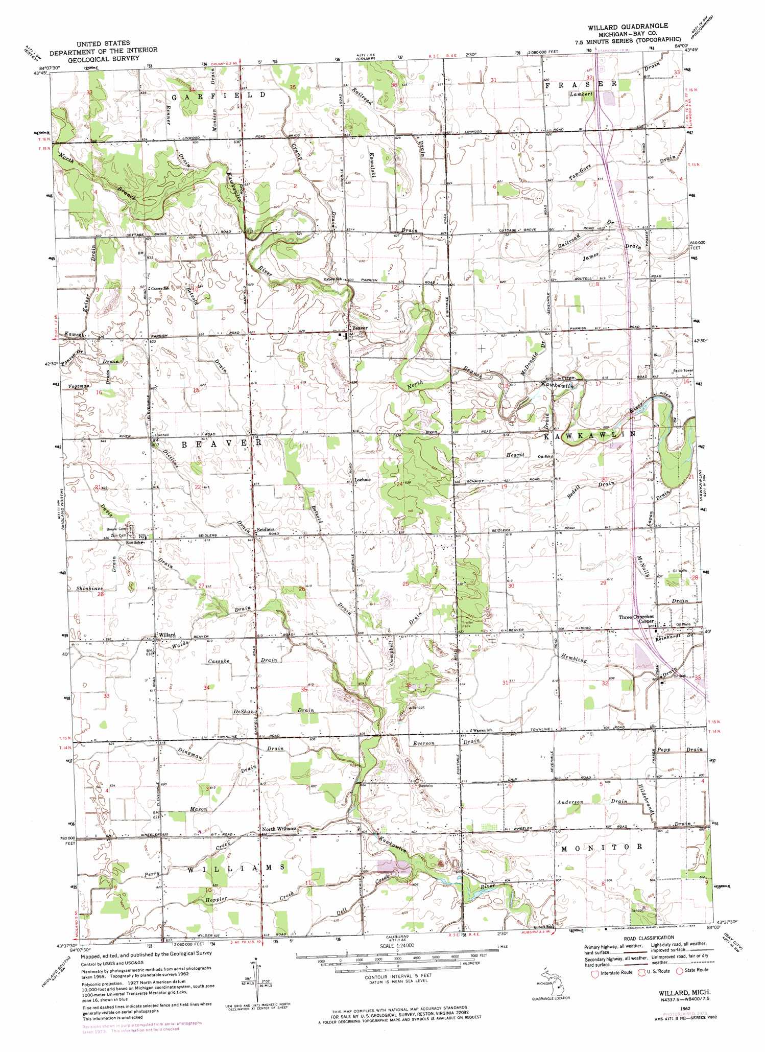
USGS Topo Quad 43084f1 - 1:24,000 scale
| Topo Map Name: | Willard |
| USGS Topo Quad ID: | 43084f1 |
| Print Size: | ca. 21 1/4" wide x 27" high |
| Southeast Coordinates: | 43.625° N latitude / 84° W longitude |
| Map Center Coordinates: | 43.6875° N latitude / 84.0625° W longitude |
| U.S. State: | MI |
| Filename: | o43084f1.jpg |
| Download Map JPG Image: | Willard topo map 1:24,000 scale |
| Map Type: | Topographic |
| Topo Series: | 7.5´ |
| Map Scale: | 1:24,000 |
| Source of Map Images: | United States Geological Survey (USGS) |
| Alternate Map Versions: |
Willard MI 1962, updated 1964 Download PDF Buy paper map Willard MI 1962, updated 1974 Download PDF Buy paper map Willard MI 2011 Download PDF Buy paper map Willard MI 2014 Download PDF Buy paper map Willard MI 2016 Download PDF Buy paper map |
1:24,000 Topo Quads surrounding Willard
Wooden Shoe Village |
Bentley |
Mount Forest |
Standish |
Standish Ne |
Hope |
Estey |
Crump |
Pinconning |
|
Averill |
Midland North |
Willard |
Kawkawlin |
Bay City Ne |
Gordonville |
Midland South |
Auburn |
Bay City |
Essexville |
Merrill |
Hemlock |
Shields |
Saginaw |
Saginaw Ne |
> Back to 43084e1 at 1:100,000 scale
> Back to 43084a1 at 1:250,000 scale
> Back to U.S. Topo Maps home
Willard topo map: Gazetteer
Willard: Canals
Anderson Drain elevation 184m 603′Betzold Drain elevation 183m 600′
Campbell Drain elevation 186m 610′
Cassube Drain elevation 186m 610′
DeShano Drain elevation 185m 606′
Dietline Drain elevation 183m 600′
Everson Drain elevation 184m 603′
Hearit Drain elevation 186m 610′
Hildebrandt Drain elevation 182m 597′
James Drain elevation 186m 610′
Kaiser Drain elevation 190m 623′
Lapan Drain elevation 184m 603′
Mason Drain elevation 186m 610′
McDonald Drain elevation 188m 616′
McNally Drain elevation 183m 600′
Reinhardt Drain elevation 182m 597′
Tap-Gove Drain elevation 185m 606′
Vogtman Drain elevation 190m 623′
Willard: Crossings
Interchange 168 elevation 185m 606′Interchange 173 elevation 187m 613′
Willard: Populated Places
Beaver elevation 192m 629′Loehme elevation 187m 613′
North Williams elevation 185m 606′
Seidlers elevation 185m 606′
Three Churches Corner elevation 184m 603′
White Birch Village Mobile Home Park elevation 190m 623′
Willard elevation 187m 613′
Willard: Post Offices
Loehne Post Office (historical) elevation 187m 613′North Williams Post Office (historical) elevation 186m 610′
Willams Post Office (historical) elevation 189m 620′
Willard Post Office (historical) elevation 187m 613′
Willard: Streams
Bedell Drain elevation 181m 593′Crump Drain elevation 187m 613′
Dell Creek elevation 181m 593′
Hoppler Creek elevation 184m 603′
Kawalski Drain elevation 186m 610′
Monison Drain elevation 190m 623′
Perry Creek elevation 181m 593′
Renner Drain elevation 189m 620′
Waldo Drain elevation 185m 606′
Willard digital topo map on disk
Buy this Willard topo map showing relief, roads, GPS coordinates and other geographical features, as a high-resolution digital map file on DVD: