Merrill Lake Topo Map Michigan
To zoom in, hover over the map of Merrill Lake
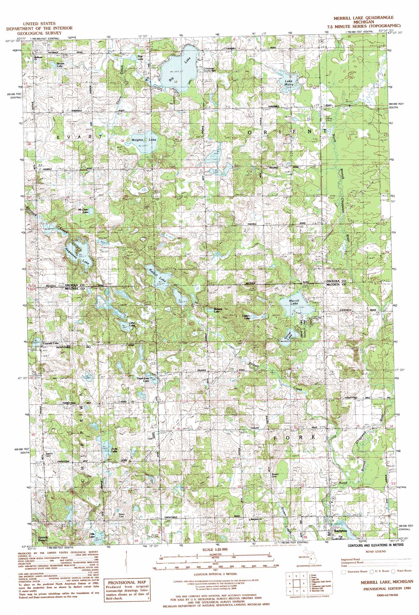
USGS Topo Quad 43085g2 - 1:25,000 scale
| Topo Map Name: | Merrill Lake |
| USGS Topo Quad ID: | 43085g2 |
| Print Size: | ca. 21 1/4" wide x 27" high |
| Southeast Coordinates: | 43.75° N latitude / 85.125° W longitude |
| Map Center Coordinates: | 43.8125° N latitude / 85.1875° W longitude |
| U.S. State: | MI |
| Filename: | l43085g2.jpg |
| Download Map JPG Image: | Merrill Lake topo map 1:25,000 scale |
| Map Type: | Topographic |
| Topo Series: | 7.5´ |
| Map Scale: | 1:25,000 |
| Source of Map Images: | United States Geological Survey (USGS) |
| Alternate Map Versions: |
Merrill Lake MI 1984, updated 1984 Download PDF Buy paper map |
1:24,000 Topo Quads surrounding Merrill Lake
Le Roy |
Dighton |
Marion |
Temple |
Prestle Creek |
Slaybaugh Corner |
Evart |
Sears |
Lake Ne |
Lake George |
Hersey |
Chippewa Lake North |
Merrill Lake |
Lake |
Woods |
Big Rapids |
Chippewa Lake South |
Mecosta Nw |
Sherman City |
Weidman |
Stanwood |
Altona |
Mecosta |
Blanchard |
Winn |
> Back to 43085e1 at 1:100,000 scale
> Back to 43084a1 at 1:250,000 scale
> Back to U.S. Topo Maps home
Merrill Lake topo map: Gazetteer
Merrill Lake: Lakes
Big Lake elevation 327m 1072′Brown Lake elevation 332m 1089′
Browns Lake elevation 323m 1059′
Emerald Lake elevation 362m 1187′
Gorrel Lake elevation 319m 1046′
Hills Lake elevation 307m 1007′
Jacks Lake elevation 330m 1082′
Lake Maloy elevation 316m 1036′
Lassen Lake elevation 325m 1066′
Lifter Lake elevation 336m 1102′
McElwin Lake elevation 344m 1128′
Merrill Lake elevation 318m 1043′
Negaunee Lake elevation 332m 1089′
Rattail Lakes elevation 326m 1069′
Rice Lake elevation 326m 1069′
Town Line Lake elevation 335m 1099′
Wrights Lake elevation 335m 1099′
Merrill Lake: Parks
Barryton Historical Marker elevation 299m 980′Crittenden County Park elevation 332m 1089′
Frank Barry Historical Marker elevation 299m 980′
Merrill Lake County Park elevation 320m 1049′
Merrill Lake: Populated Places
Barryton elevation 299m 980′Gibos Corners (historical) elevation 312m 1023′
Merrill Lake: Post Offices
Barryton Post Office elevation 299m 980′Emerald Post Office (historical) elevation 369m 1210′
Orient Post Office (historical) elevation 312m 1023′
Merrill Lake: Streams
Benjamin Creek elevation 309m 1013′Browne Creek elevation 311m 1020′
Butts Creek elevation 302m 990′
Rattail Creek elevation 296m 971′
Merrill Lake digital topo map on disk
Buy this Merrill Lake topo map showing relief, roads, GPS coordinates and other geographical features, as a high-resolution digital map file on DVD: