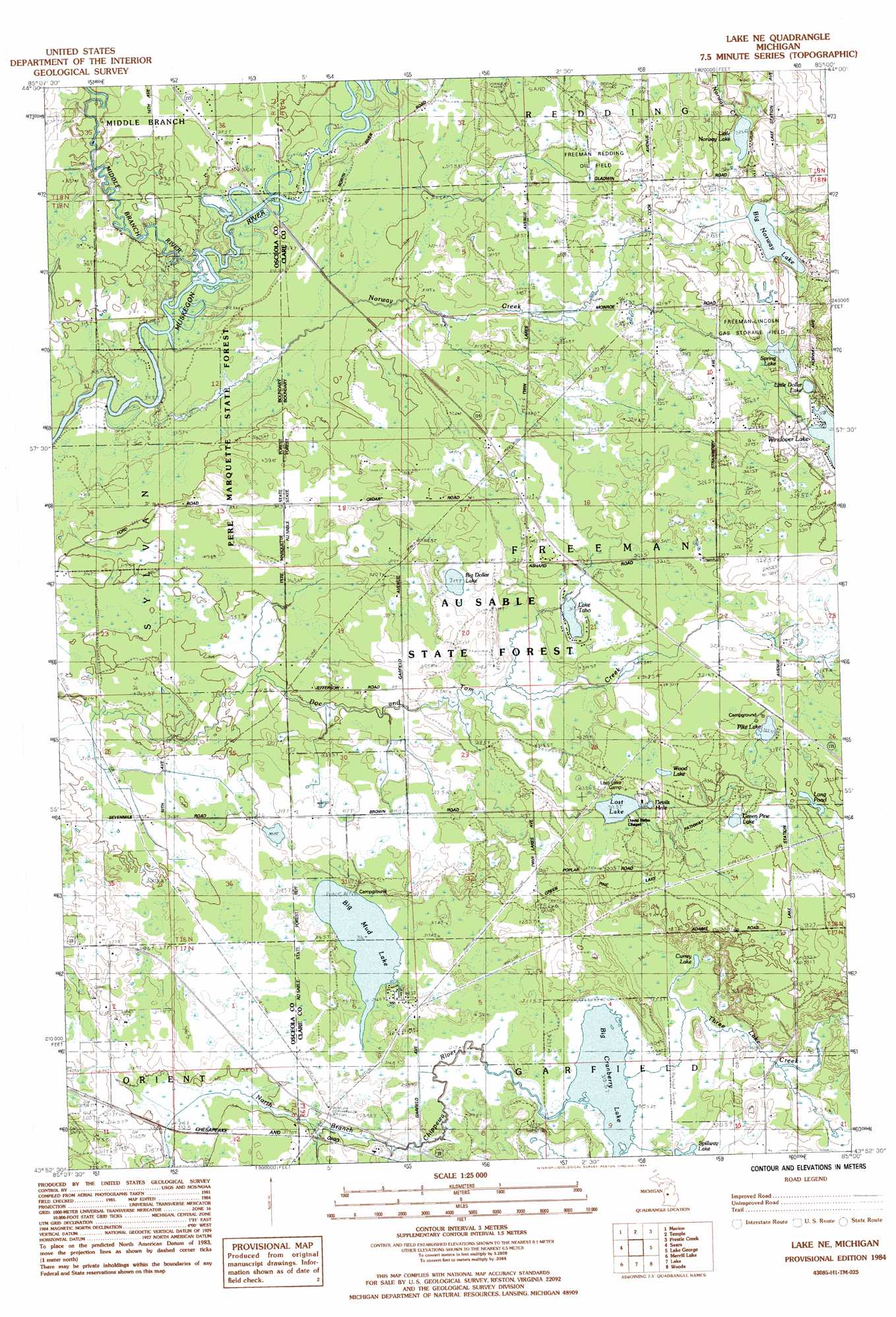
Lake Ne Topo Map Michigan
To zoom in, hover over the map of Lake Ne
USGS Topo Quad 43085h1 - 1:25,000 scale
| Topo Map Name: | Lake Ne |
| USGS Topo Quad ID: | 43085h1 |
| Print Size: | ca. 21 1/4" wide x 27" high |
| Southeast Coordinates: | 43.875° N latitude / 85° W longitude |
| Map Center Coordinates: | 43.9375° N latitude / 85.0625° W longitude |
| U.S. State: | MI |
| Filename: | l43085h1.jpg |
| Download Map JPG Image: | Lake Ne topo map 1:25,000 scale |
| Map Type: | Topographic |
| Topo Series: | 7.5´ |
| Map Scale: | 1:25,000 |
| Source of Map Images: | United States Geological Survey (USGS) |
| Alternate Map Versions: |
Lake NE MI 1984, updated 1984 Download PDF Buy paper map |
1:24,000 Topo Quads surrounding Lake Ne
Lucas |
Mcbain |
Falmouth |
Moddersville |
Cooperton |
Dighton |
Marion |
Temple |
Prestle Creek |
Harrison |
Evart |
Sears |
Lake Ne |
Lake George |
Hatton |
Chippewa Lake North |
Merrill Lake |
Lake |
Woods |
Clare |
Chippewa Lake South |
Mecosta Nw |
Sherman City |
Weidman |
Rosebush |
> Back to 43085e1 at 1:100,000 scale
> Back to 43084a1 at 1:250,000 scale
> Back to U.S. Topo Maps home
Lake Ne topo map: Gazetteer
Lake Ne: Airports
Doss Field elevation 321m 1053′Lake Ne: Lakes
Big Cranberry Lake elevation 315m 1033′Big Dollar Lake elevation 319m 1046′
Big Mud Lake elevation 316m 1036′
Big Norway Lake elevation 325m 1066′
Currey Lake elevation 320m 1049′
Green Pine Lake elevation 327m 1072′
Lake Ernestine elevation 327m 1072′
Lake Taho elevation 317m 1040′
Little Norway Lake elevation 325m 1066′
Long Lake elevation 330m 1082′
Long Pond elevation 328m 1076′
Lost Lake elevation 317m 1040′
Pike Lake elevation 322m 1056′
Spring Lake elevation 325m 1066′
Wood Lake elevation 323m 1059′
Lake Ne: Populated Places
Chippewa elevation 315m 1033′Lake Ne: Post Offices
Chippewa Station Post Office (historical) elevation 315m 1033′Lake Ne: Streams
Middle Branch River elevation 311m 1020′Norway Creek elevation 309m 1013′
Three Lake Creek elevation 318m 1043′
Lake Ne digital topo map on disk
Buy this Lake Ne topo map showing relief, roads, GPS coordinates and other geographical features, as a high-resolution digital map file on DVD: