Wolf Lake Topo Map Michigan
To zoom in, hover over the map of Wolf Lake
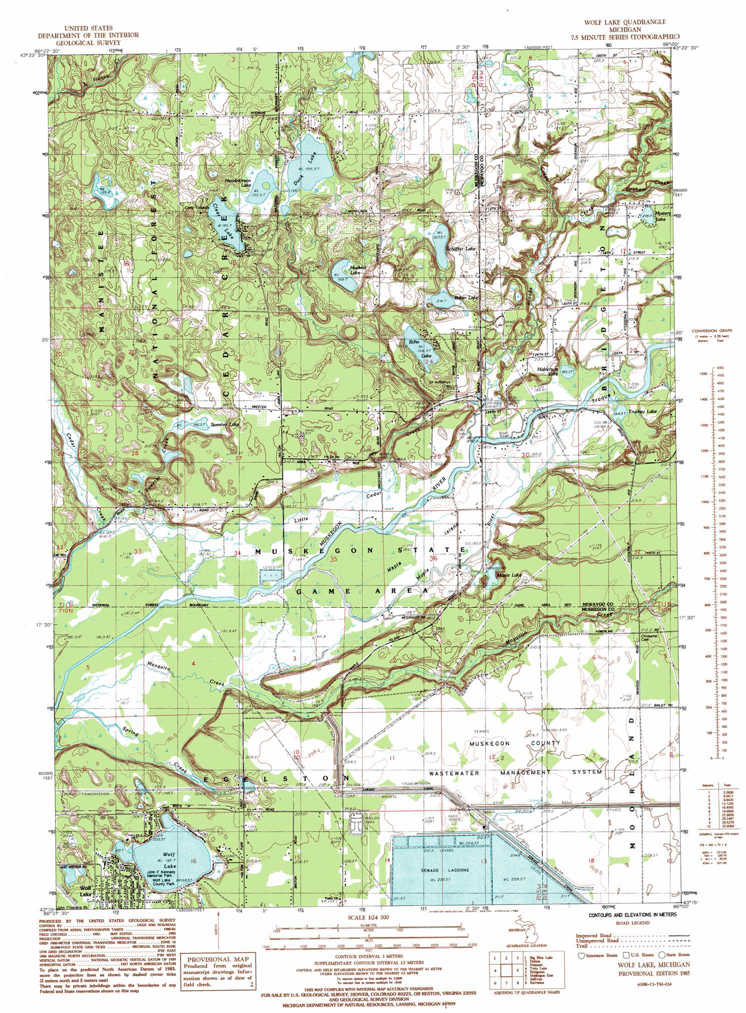
USGS Topo Quad 43086c1 - 1:24,000 scale
| Topo Map Name: | Wolf Lake |
| USGS Topo Quad ID: | 43086c1 |
| Print Size: | ca. 21 1/4" wide x 27" high |
| Southeast Coordinates: | 43.25° N latitude / 86° W longitude |
| Map Center Coordinates: | 43.3125° N latitude / 86.0625° W longitude |
| U.S. State: | MI |
| Filename: | o43086c1.jpg |
| Download Map JPG Image: | Wolf Lake topo map 1:24,000 scale |
| Map Type: | Topographic |
| Topo Series: | 7.5´ |
| Map Scale: | 1:24,000 |
| Source of Map Images: | United States Geological Survey (USGS) |
| Alternate Map Versions: |
Wolf Lake MI 1985, updated 1985 Download PDF Buy paper map Wolf Lake MI 2012 Download PDF Buy paper map Wolf Lake MI 2014 Download PDF Buy paper map Wolf Lake MI 2017 Download PDF Buy paper map |
| FStopo: | US Forest Service topo Wolf Lake is available: Download FStopo PDF Download FStopo TIF |
1:24,000 Topo Quads surrounding Wolf Lake
Shelby |
Ferry |
Hesperia |
Dayton Center |
White Cloud |
Montague |
Big Blue Lake |
Holton |
Fremont |
Newaygo |
Dalton |
Twin Lake |
Wolf Lake |
Bridgeton |
Grant |
Muskegon West |
Muskegon East |
Sullivan |
Ravenna |
Casnovia |
Grand Haven |
Nunica |
Coopersville |
Marne |
> Back to 43086a1 at 1:100,000 scale
> Back to 43086a1 at 1:250,000 scale
> Back to U.S. Topo Maps home
Wolf Lake topo map: Gazetteer
Wolf Lake: Capes
Indian Point elevation 183m 600′Wolf Lake: Islands
Maple Island elevation 184m 603′Troque Island elevation 185m 606′
Wolf Lake: Lakes
Baker Lake elevation 214m 702′Clear Lake elevation 196m 643′
Duck Lake elevation 195m 639′
Echo Lake elevation 196m 643′
Halverson Lake elevation 185m 606′
Hendrickson Lake elevation 195m 639′
Maple Lake elevation 185m 606′
Muskrat Lake elevation 198m 649′
Mystery Lake elevation 215m 705′
Schaffer Lake elevation 207m 679′
Sweeter Lake elevation 187m 613′
Truckey Lake elevation 184m 603′
Wolf Lake elevation 195m 639′
Wolf Lake: Parks
John F Kennedy Memorial Park elevation 204m 669′Wolf Lake County Park elevation 205m 672′
Wolf Lake: Populated Places
Maple Island Estates Mobile Home Park elevation 207m 679′Wolf Lake elevation 205m 672′
Wolf Lake: Post Offices
Sweeter Post Office (historical) elevation 211m 692′Wolf Lake: Streams
Brooks Creek elevation 183m 600′Cow Creek elevation 190m 623′
Graham Creek elevation 190m 623′
Little Cedar Creek elevation 183m 600′
Little Henna Creek elevation 194m 636′
Maple River elevation 183m 600′
Mosquito Creek elevation 180m 590′
Spring Creek elevation 180m 590′
Sweeter Creek elevation 183m 600′
Wolf Lake: Trails
Cedar Creek Cycle Trail elevation 212m 695′Wolf Lake digital topo map on disk
Buy this Wolf Lake topo map showing relief, roads, GPS coordinates and other geographical features, as a high-resolution digital map file on DVD: