Holton Topo Map Michigan
To zoom in, hover over the map of Holton
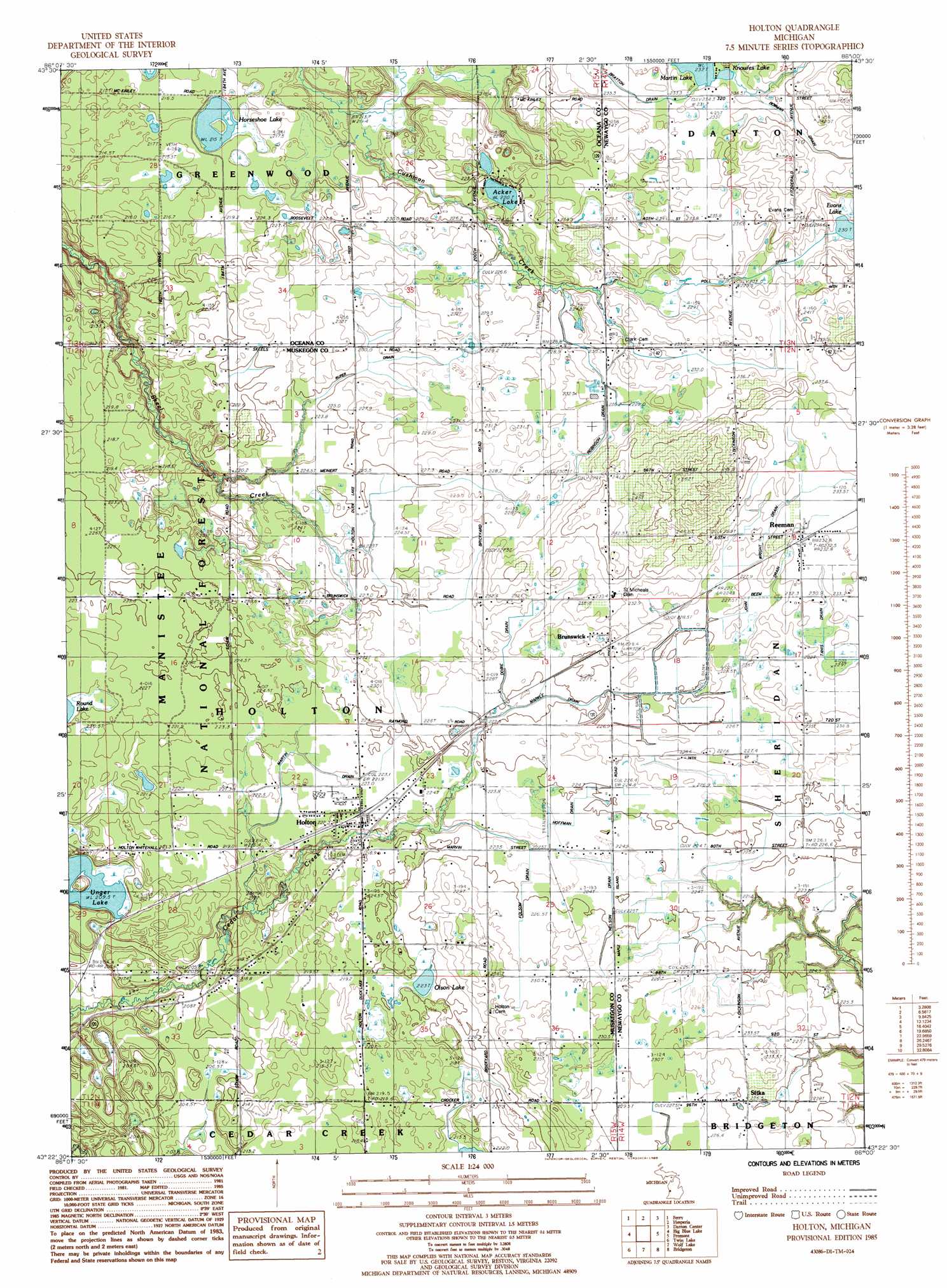
USGS Topo Quad 43086d1 - 1:24,000 scale
| Topo Map Name: | Holton |
| USGS Topo Quad ID: | 43086d1 |
| Print Size: | ca. 21 1/4" wide x 27" high |
| Southeast Coordinates: | 43.375° N latitude / 86° W longitude |
| Map Center Coordinates: | 43.4375° N latitude / 86.0625° W longitude |
| U.S. State: | MI |
| Filename: | o43086d1.jpg |
| Download Map JPG Image: | Holton topo map 1:24,000 scale |
| Map Type: | Topographic |
| Topo Series: | 7.5´ |
| Map Scale: | 1:24,000 |
| Source of Map Images: | United States Geological Survey (USGS) |
| Alternate Map Versions: |
Holton MI 1985, updated 1985 Download PDF Buy paper map Holton MI 2012 Download PDF Buy paper map Holton MI 2014 Download PDF Buy paper map Holton MI 2017 Download PDF Buy paper map |
| FStopo: | US Forest Service topo Holton is available: Download FStopo PDF Download FStopo TIF |
1:24,000 Topo Quads surrounding Holton
Hart Ne |
Walkerville West |
Walkerville East |
Walkup Lake |
Woodland Park |
Shelby |
Ferry |
Hesperia |
Dayton Center |
White Cloud |
Montague |
Big Blue Lake |
Holton |
Fremont |
Newaygo |
Dalton |
Twin Lake |
Wolf Lake |
Bridgeton |
Grant |
Muskegon West |
Muskegon East |
Sullivan |
Ravenna |
Casnovia |
> Back to 43086a1 at 1:100,000 scale
> Back to 43086a1 at 1:250,000 scale
> Back to U.S. Topo Maps home
Holton topo map: Gazetteer
Holton: Canals
Dobie Drain elevation 226m 741′Folsom Drain elevation 224m 734′
Hoffman Drain elevation 224m 734′
John Beem Drain elevation 228m 748′
Markle Drain elevation 223m 731′
Martin Drain elevation 222m 728′
Nelson Drain elevation 223m 731′
Poll Drain elevation 230m 754′
Robinson Drain elevation 228m 748′
Ruper Drain elevation 226m 741′
Holton: Lakes
Acker Lake elevation 220m 721′Evans Lake elevation 230m 754′
Knowles Lake elevation 232m 761′
Little Martin Lake elevation 232m 761′
Olson Lake elevation 223m 731′
Unger Lake elevation 209m 685′
Holton: Populated Places
Brunswick elevation 228m 748′Holton elevation 222m 728′
Reeman elevation 232m 761′
Sitka elevation 226m 741′
Holton: Post Offices
Brunswick Post Office elevation 229m 751′Forest City Post Office (historical) elevation 230m 754′
Hazel Grove Post Office (historical) elevation 216m 708′
Holton Post Office elevation 224m 734′
Reeman Post Office (historical) elevation 232m 761′
Sitka Post Office (historical) elevation 226m 741′
Holton: Streams
Bowman Drain elevation 232m 761′Brayden Creek elevation 233m 764′
Dragoo Creek elevation 233m 764′
Holton: Swamps
Horseshoe Lake elevation 215m 705′Holton digital topo map on disk
Buy this Holton topo map showing relief, roads, GPS coordinates and other geographical features, as a high-resolution digital map file on DVD: