Flower Creek Topo Map Michigan
To zoom in, hover over the map of Flower Creek
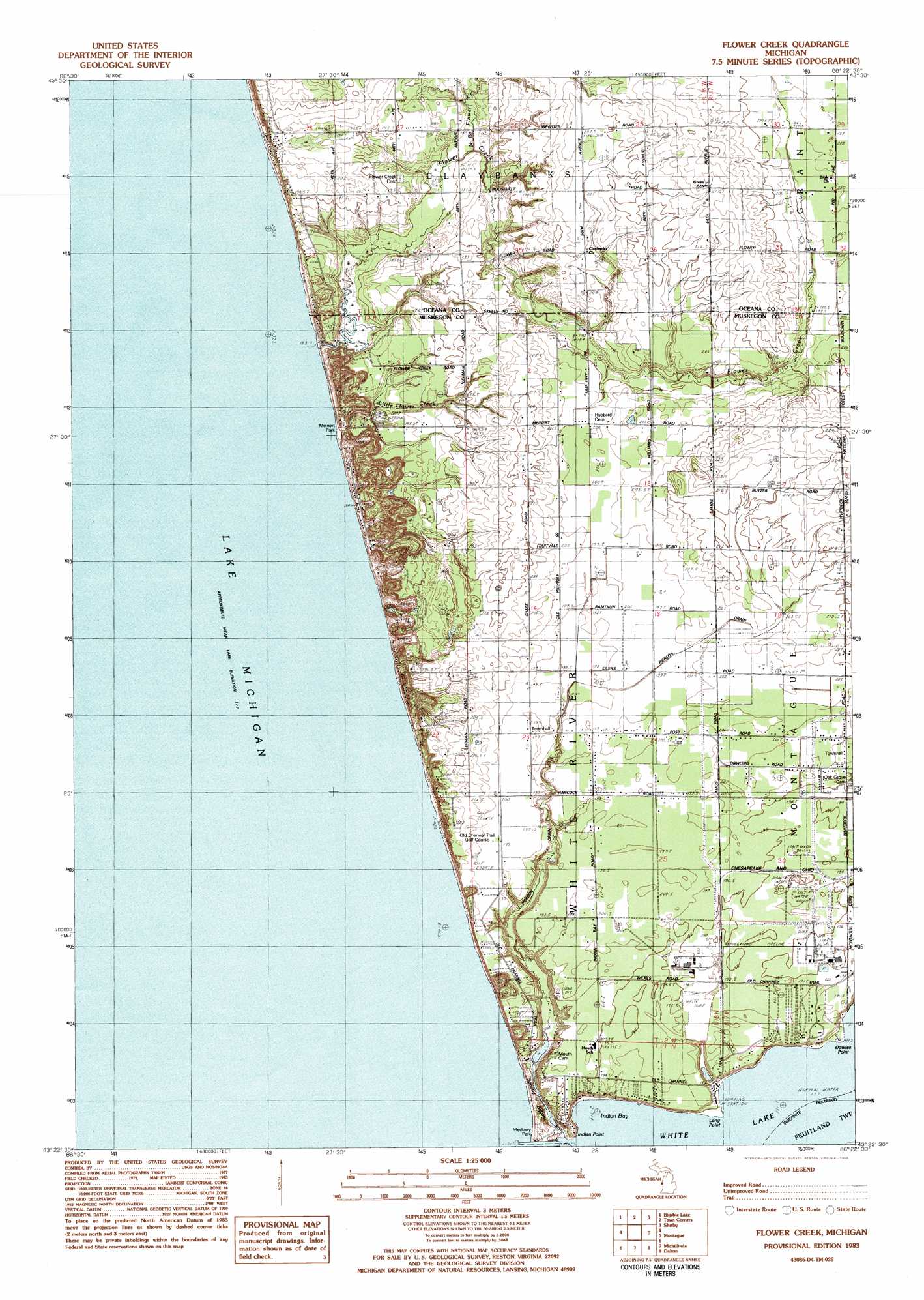
USGS Topo Quad 43086d4 - 1:25,000 scale
| Topo Map Name: | Flower Creek |
| USGS Topo Quad ID: | 43086d4 |
| Print Size: | ca. 21 1/4" wide x 27" high |
| Southeast Coordinates: | 43.375° N latitude / 86.375° W longitude |
| Map Center Coordinates: | 43.4375° N latitude / 86.4375° W longitude |
| U.S. State: | MI |
| Filename: | l43086d4.jpg |
| Download Map JPG Image: | Flower Creek topo map 1:25,000 scale |
| Map Type: | Topographic |
| Topo Series: | 7.5´ |
| Map Scale: | 1:25,000 |
| Source of Map Images: | United States Geological Survey (USGS) |
| Alternate Map Versions: |
Flower Creek MI 1983, updated 1983 Download PDF Buy paper map |
| FStopo: | US Forest Service topo Flower Creek is available: Download FStopo PDF Download FStopo TIF |
1:24,000 Topo Quads surrounding Flower Creek
Little Point Sable |
Mears |
Hart Ne |
Walkerville West |
|
Bigsbie Lake |
Town Corners |
Shelby |
Ferry |
|
Flower Creek |
Montague |
Big Blue Lake |
||
Michillinda |
Dalton |
Twin Lake |
||
Muskegon West |
Muskegon East |
> Back to 43086a1 at 1:100,000 scale
> Back to 43086a1 at 1:250,000 scale
> Back to U.S. Topo Maps home
Flower Creek topo map: Gazetteer
Flower Creek: Bays
Indian Bay elevation 177m 580′Flower Creek: Canals
Pierson Drain elevation 180m 590′Flower Creek: Capes
Dowies Point elevation 177m 580′Indian Point elevation 181m 593′
Long Point elevation 178m 583′
Flower Creek: Lakes
Sadony Bayou elevation 186m 610′White Lake elevation 177m 580′
Flower Creek: Parks
Medbury Park elevation 183m 600′Meinert Park elevation 178m 583′
Montague Township Park elevation 198m 649′
Mouth Cemetery Historical Marker elevation 196m 643′
Flower Creek: Post Offices
Flowercreek Post Office (historical) elevation 208m 682′Flower Creek: Streams
Flower Creek elevation 177m 580′Little Flower Creek elevation 181m 593′
North Branch Flower Creek elevation 180m 590′
Flower Creek digital topo map on disk
Buy this Flower Creek topo map showing relief, roads, GPS coordinates and other geographical features, as a high-resolution digital map file on DVD: