Walkerville East Topo Map Michigan
To zoom in, hover over the map of Walkerville East
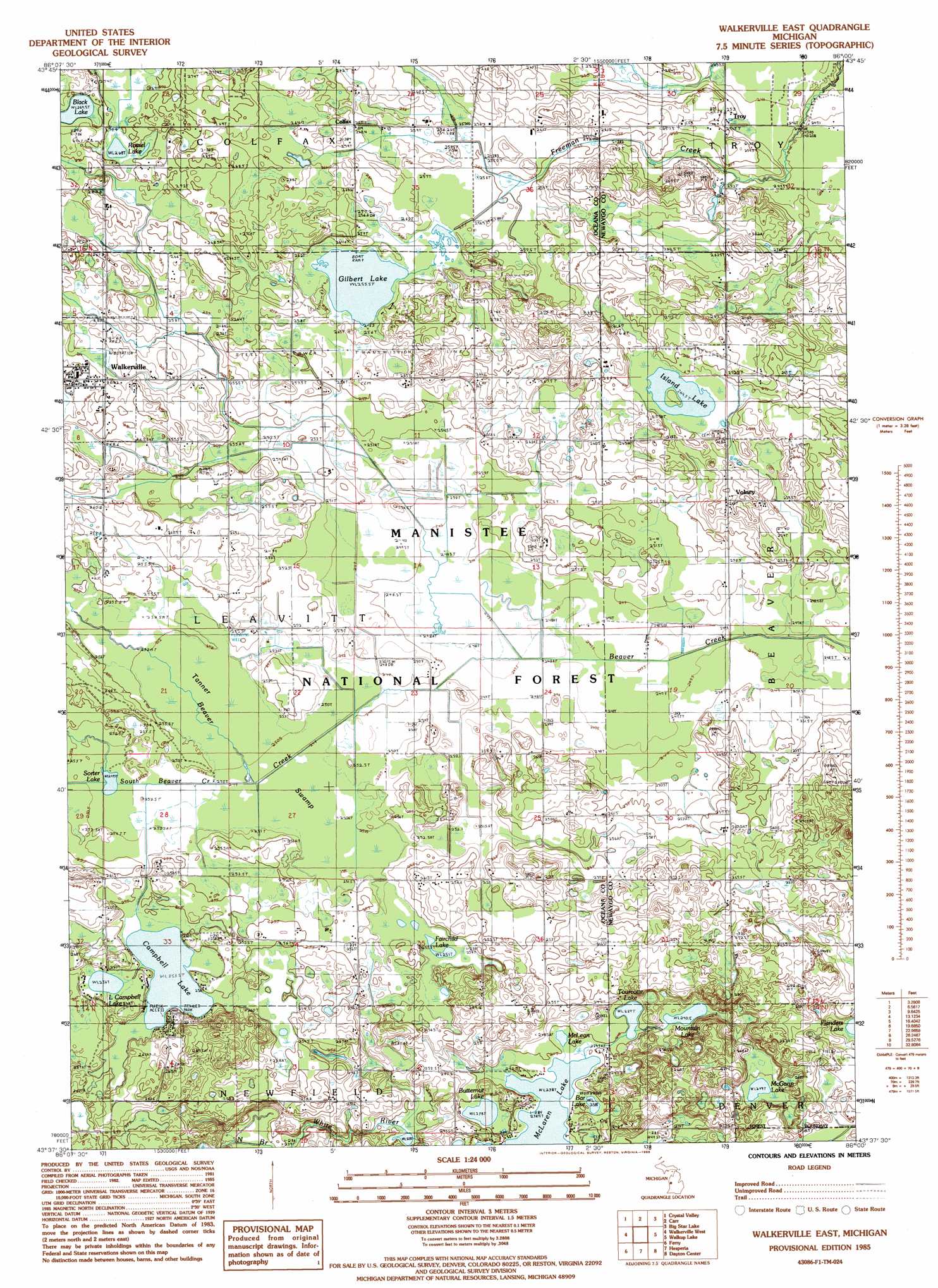
USGS Topo Quad 43086f1 - 1:24,000 scale
| Topo Map Name: | Walkerville East |
| USGS Topo Quad ID: | 43086f1 |
| Print Size: | ca. 21 1/4" wide x 27" high |
| Southeast Coordinates: | 43.625° N latitude / 86° W longitude |
| Map Center Coordinates: | 43.6875° N latitude / 86.0625° W longitude |
| U.S. State: | MI |
| Filename: | o43086f1.jpg |
| Download Map JPG Image: | Walkerville East topo map 1:24,000 scale |
| Map Type: | Topographic |
| Topo Series: | 7.5´ |
| Map Scale: | 1:24,000 |
| Source of Map Images: | United States Geological Survey (USGS) |
| Alternate Map Versions: |
Walkerville East MI 1985, updated 1985 Download PDF Buy paper map Walkerville East MI 2012 Download PDF Buy paper map Walkerville East MI 2014 Download PDF Buy paper map Walkerville East MI 2017 Download PDF Buy paper map |
| FStopo: | US Forest Service topo Walkerville East is available: Download FStopo PDF Download FStopo TIF |
1:24,000 Topo Quads surrounding Walkerville East
Ludington Ne |
Custer Nw |
Custer Ne |
Townsend Lake |
Baldwin |
Wiley |
Custer Sw |
Custer Se |
Big Star Lake |
Marlborough |
Hart Ne |
Walkerville West |
Walkerville East |
Walkup Lake |
Woodland Park |
Shelby |
Ferry |
Hesperia |
Dayton Center |
White Cloud |
Montague |
Big Blue Lake |
Holton |
Fremont |
Newaygo |
> Back to 43086e1 at 1:100,000 scale
> Back to 43086a1 at 1:250,000 scale
> Back to U.S. Topo Maps home
Walkerville East topo map: Gazetteer
Walkerville East: Lakes
Bar Lake elevation 240m 787′Black Lake elevation 269m 882′
Butternut Lake elevation 238m 780′
Campbell Lake elevation 253m 830′
Fairchild Lake elevation 251m 823′
Flanders Lake elevation 245m 803′
Gilbert Lake elevation 255m 836′
Island Lake elevation 264m 866′
Little Campbell Lake elevation 256m 839′
McGann Lake elevation 249m 816′
McLaren Lake elevation 239m 784′
McLeam Lake elevation 238m 780′
Mountain Lake elevation 240m 787′
Rossel Lake elevation 268m 879′
Sorter Lake elevation 249m 816′
Tourcotte Lake elevation 242m 793′
Walkerville East: Oilfields
Gilbert Lake Oil Field elevation 264m 866′Huber Oil Field elevation 252m 826′
Walkerville East: Populated Places
Colfax elevation 260m 853′Troy elevation 251m 823′
Volney elevation 268m 879′
Walkerville elevation 270m 885′
Walkerville East: Post Offices
Beaver Post Office (historical) elevation 272m 892′Bird Post Office (historical) elevation 262m 859′
Klondike Post Office (historical) elevation 256m 839′
Volney Post Office (historical) elevation 268m 879′
Walkerville Post Office elevation -1m -4′
Walkerville East: Streams
South Beaver Creek elevation 249m 816′Walkerville East: Swamps
Tanner Swamp elevation 255m 836′Walkerville East digital topo map on disk
Buy this Walkerville East topo map showing relief, roads, GPS coordinates and other geographical features, as a high-resolution digital map file on DVD: