Custer Nw Topo Map Michigan
To zoom in, hover over the map of Custer Nw
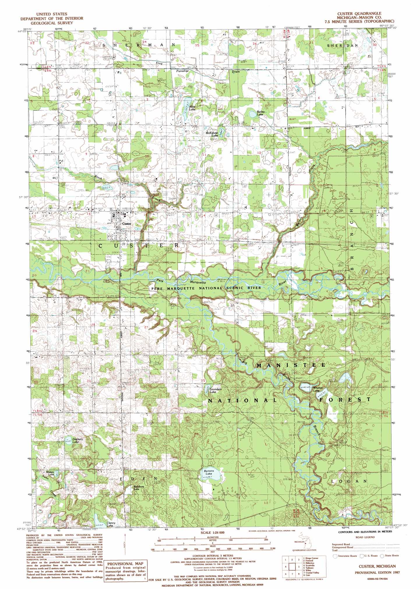
USGS Topo Quad 43086h2 - 1:24,000 scale
| Topo Map Name: | Custer Nw |
| USGS Topo Quad ID: | 43086h2 |
| Print Size: | ca. 21 1/4" wide x 27" high |
| Southeast Coordinates: | 43.875° N latitude / 86.125° W longitude |
| Map Center Coordinates: | 43.9375° N latitude / 86.1875° W longitude |
| U.S. State: | MI |
| Filename: | o43086h2.jpg |
| Download Map JPG Image: | Custer Nw topo map 1:24,000 scale |
| Map Type: | Topographic |
| Topo Series: | 7.5´ |
| Map Scale: | 1:24,000 |
| Source of Map Images: | United States Geological Survey (USGS) |
| Alternate Map Versions: |
Custer MI 1987, updated 1988 Download PDF Buy paper map Custer MI 2012 Download PDF Buy paper map Custer MI 2014 Download PDF Buy paper map Custer MI 2017 Download PDF Buy paper map |
| FStopo: | US Forest Service topo Custer is available: Download FStopo PDF Download FStopo TIF |
1:24,000 Topo Quads surrounding Custer Nw
Manistee Nw |
Manistee Ne |
Freesoil Nw |
Freesoil Ne |
Peacock Nw |
Hamlin Lake |
Kings Corners |
Freesoil Sw |
Freesoil Se |
Peacock Sw |
Ludington Nw |
Ludington Ne |
Custer Nw |
Custer Ne |
Townsend Lake |
Pentwater |
Wiley |
Custer Sw |
Custer Se |
Big Star Lake |
Mears |
Hart Ne |
Walkerville West |
Walkerville East |
Walkup Lake |
> Back to 43086e1 at 1:100,000 scale
> Back to 43086a1 at 1:250,000 scale
> Back to U.S. Topo Maps home
Custer Nw topo map: Gazetteer
Custer Nw: Lakes
Allen Lake elevation 208m 682′Bailey Lake elevation 208m 682′
Bartons Lake elevation 208m 682′
Clancy Lake elevation 213m 698′
Dockery Lake elevation 214m 702′
McKimzie Lake elevation 210m 688′
Mobey Lake elevation 211m 692′
Saunders Lake elevation 209m 685′
Whelan Lake elevation 192m 629′
Custer Nw: Parks
Notipekago Historical Marker elevation 185m 606′Custer Nw: Populated Places
Custer elevation 206m 675′Custer Nw: Post Offices
Custer Post Office elevation 211m 692′Weldon Creek Post Office (historical) elevation 210m 688′
Custer Nw: Streams
Big South Branch Pere Marquette River elevation 185m 606′Black Creek elevation 184m 603′
Hatting Creek elevation 198m 649′
Weldon Creek elevation 189m 620′
Custer Nw: Swamps
Rathburn Lake elevation 214m 702′Custer Nw: Trails
Indian Trail elevation 203m 666′Custer Nw digital topo map on disk
Buy this Custer Nw topo map showing relief, roads, GPS coordinates and other geographical features, as a high-resolution digital map file on DVD: