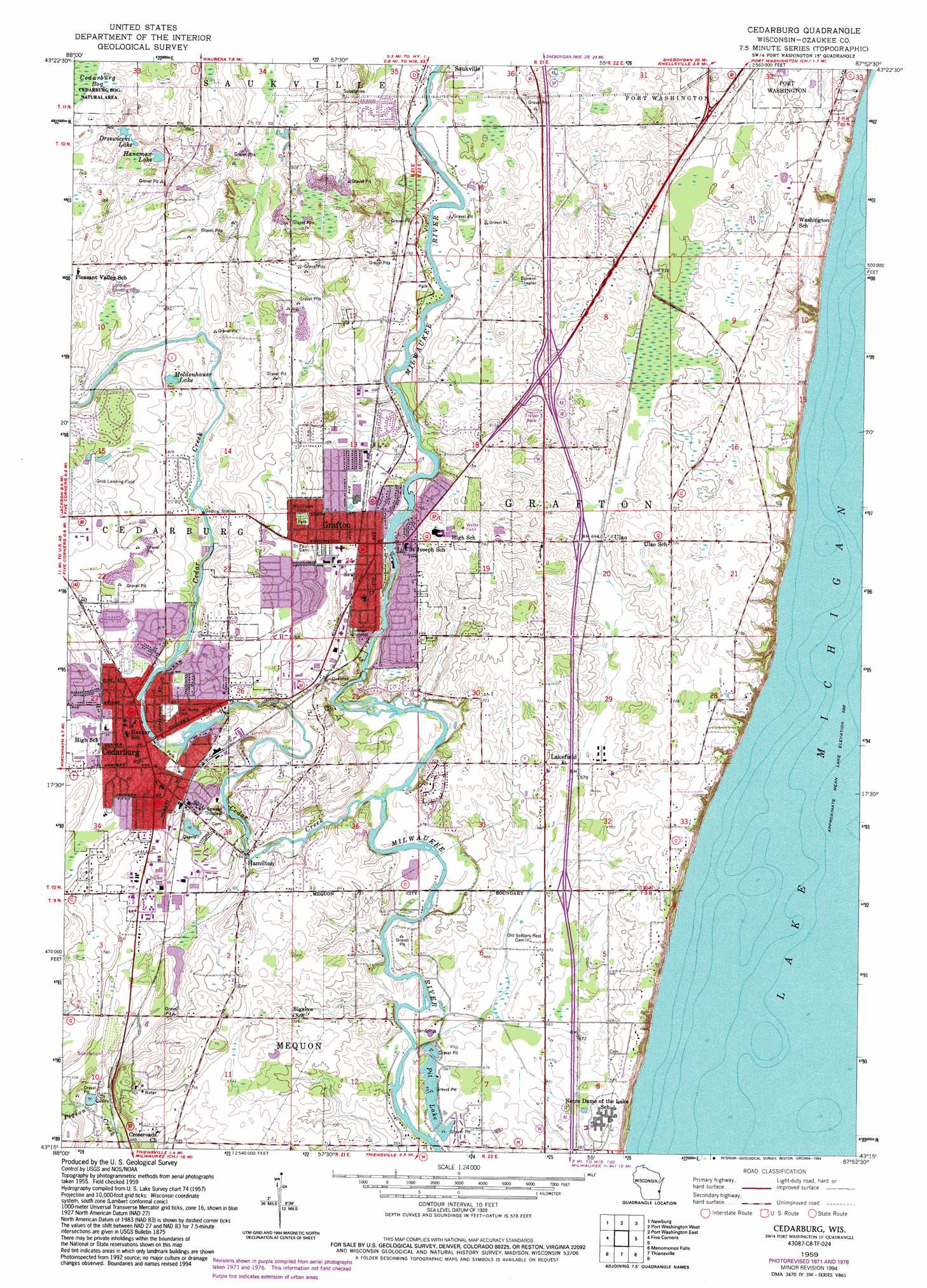
Cedarburg Topo Map Wisconsin
To zoom in, hover over the map of Cedarburg
USGS Topo Quad 43087c8 - 1:24,000 scale
| Topo Map Name: | Cedarburg |
| USGS Topo Quad ID: | 43087c8 |
| Print Size: | ca. 21 1/4" wide x 27" high |
| Southeast Coordinates: | 43.25° N latitude / 87.875° W longitude |
| Map Center Coordinates: | 43.3125° N latitude / 87.9375° W longitude |
| U.S. State: | WI |
| Filename: | o43087c8.jpg |
| Download Map JPG Image: | Cedarburg topo map 1:24,000 scale |
| Map Type: | Topographic |
| Topo Series: | 7.5´ |
| Map Scale: | 1:24,000 |
| Source of Map Images: | United States Geological Survey (USGS) |
| Alternate Map Versions: |
Cedarburg WI 1959, updated 1960 Download PDF Buy paper map Cedarburg WI 1959, updated 1972 Download PDF Buy paper map Cedarburg WI 1959, updated 1977 Download PDF Buy paper map Cedarburg WI 1959, updated 1994 Download PDF Buy paper map Cedarburg WI 2010 Download PDF Buy paper map Cedarburg WI 2013 Download PDF Buy paper map Cedarburg WI 2016 Download PDF Buy paper map |
1:24,000 Topo Quads surrounding Cedarburg
Kewaskum |
Batavia |
Random Lake |
Cedar Grove |
|
West Bend |
Newburg |
Port Washington West |
Port Washington East |
|
Jackson |
Five Corners |
Cedarburg |
||
Sussex |
Menomonee Falls |
Thiensville |
||
Waukesha |
Wauwatosa |
Milwaukee |
> Back to 43087a1 at 1:100,000 scale
> Back to 43086a1 at 1:250,000 scale
> Back to U.S. Topo Maps home
Cedarburg topo map: Gazetteer
Cedarburg: Airports
Ashenfelter Aerodrome elevation 260m 853′Flying S Ranch Airport elevation 215m 705′
Grob Airport elevation 263m 862′
Hoffman Prop Inc Heliport elevation 222m 728′
Laftheim Landing Strip elevation 260m 853′
SSS Aerodrome elevation 243m 797′
Cedarburg: Crossings
Interchange 89 elevation 204m 669′Interchange 92 elevation 213m 698′
Interchange 93 elevation 226m 741′
Cedarburg: Dams
Cedarburg Woolen Mill Dam elevation 241m 790′Columbia Mills Dam elevation 236m 774′
G E Harris G8925 Dam elevation 250m 820′
Grafton Dam elevation 224m 734′
Ruck Dam elevation 234m 767′
Cedarburg: Lakes
Drzewiceki Lake elevation 264m 866′Haneman Lake elevation 256m 839′
Moldenhauer Lake elevation 250m 820′
Pit Lake elevation 200m 656′
Cedarburg: Parks
Adlai Horn Park elevation 235m 770′Cedar Creek Park elevation 235m 770′
Centennial Park elevation 252m 826′
Firemen's Park elevation 251m 823′
Hamilton Park elevation 215m 705′
Herman A Zeunert Park elevation 222m 728′
Kurtz Woods State Natural Area elevation 252m 826′
Legion Memorial Park elevation 236m 774′
Lime Kiln Park elevation 221m 725′
Meadowbrook Park elevation 228m 748′
Mee-Kwon Park elevation 227m 744′
Mequon Rotary Park elevation 210m 688′
River Island Park elevation 227m 744′
Veterans Memorial Park elevation 225m 738′
Wildwood Park elevation 243m 797′
Willowbrooke Park elevation 252m 826′
Woodland Park elevation 249m 816′
Cedarburg: Populated Places
Cedarburg elevation 239m 784′Grafton elevation 231m 757′
Hamilton elevation 214m 702′
Lakefield elevation 216m 708′
Ulao elevation 211m 692′
Cedarburg: Post Offices
Cedarburg Post Office elevation 239m 784′Cedarburg: Reservoirs
0.45 Reservoir elevation 250m 820′119 Reservoir elevation 241m 790′
120 Reservoir elevation 234m 767′
451 Reservoir elevation 224m 734′
Cedarburg Pond 121 elevation 236m 774′
Cedarburg: Streams
Cedar Creek elevation 205m 672′Cedarburg: Woods
Pukaite Woods elevation 210m 688′Cedarburg digital topo map on disk
Buy this Cedarburg topo map showing relief, roads, GPS coordinates and other geographical features, as a high-resolution digital map file on DVD: