Wauwatosa Topo Map Wisconsin
To zoom in, hover over the map of Wauwatosa
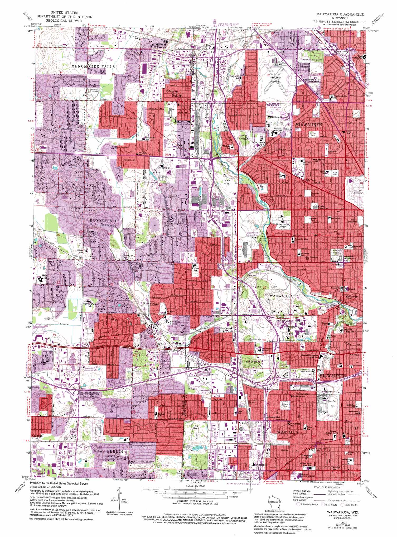
USGS Topo Quad 43088a1 - 1:24,000 scale
| Topo Map Name: | Wauwatosa |
| USGS Topo Quad ID: | 43088a1 |
| Print Size: | ca. 21 1/4" wide x 27" high |
| Southeast Coordinates: | 43° N latitude / 88° W longitude |
| Map Center Coordinates: | 43.0625° N latitude / 88.0625° W longitude |
| U.S. State: | WI |
| Filename: | o43088a1.jpg |
| Download Map JPG Image: | Wauwatosa topo map 1:24,000 scale |
| Map Type: | Topographic |
| Topo Series: | 7.5´ |
| Map Scale: | 1:24,000 |
| Source of Map Images: | United States Geological Survey (USGS) |
| Alternate Map Versions: |
Wauwatosa WI 1958, updated 1961 Download PDF Buy paper map Wauwatosa WI 1958, updated 1973 Download PDF Buy paper map Wauwatosa WI 1958, updated 1982 Download PDF Buy paper map Wauwatosa WI 1958, updated 1994 Download PDF Buy paper map Wauwatosa WI 2010 Download PDF Buy paper map Wauwatosa WI 2013 Download PDF Buy paper map Wauwatosa WI 2015 Download PDF Buy paper map |
1:24,000 Topo Quads surrounding Wauwatosa
Hartford East |
Jackson |
Five Corners |
Cedarburg |
|
Merton |
Sussex |
Menomonee Falls |
Thiensville |
|
Hartland |
Waukesha |
Wauwatosa |
Milwaukee |
|
Genesee |
Muskego |
Hales Corners |
Greendale |
South Milwaukee |
Mukwonago |
Waterford |
North Cape |
Franksville |
Racine North |
> Back to 43088a1 at 1:100,000 scale
> Back to 43088a1 at 1:250,000 scale
> Back to U.S. Topo Maps home
Wauwatosa topo map: Gazetteer
Wauwatosa: Airports
Lawrence J Timmerman Airport elevation 224m 734′Milwaukee County Medical Complex Heliport elevation 217m 711′
Wauwatosa: Canals
Dousman Ditch elevation 252m 826′Wauwatosa: Crossings
Interchange 1 elevation 243m 797′Interchange 301 elevation 256m 839′
Interchange 304 elevation 229m 751′
Interchange 305 elevation 238m 780′
Interchange 306 elevation 213m 698′
Wauwatosa: Parks
Brookfield Meadows Park elevation 273m 895′Buena Park elevation 258m 846′
Cannon Park elevation 240m 787′
Cardinal Crest Park elevation 222m 728′
Chippewa Park elevation 225m 738′
Columbus Park elevation 213m 698′
Concordia Park elevation 228m 748′
Cooper Park elevation 228m 748′
Currie Park elevation 225m 738′
Elm Grove Village Park elevation 229m 751′
Enderis Playground elevation 233m 764′
Franklin Wirth Park elevation 252m 826′
Frontier Park elevation 216m 708′
Gatewood Park elevation 256m 839′
Gravel Sholes Park elevation 219m 718′
Greenfield Park elevation 231m 757′
Honey Creek Park elevation 222m 728′
Kinsey Park elevation 238m 780′
Kopperud Park elevation 217m 711′
Krueger Park elevation 221m 725′
LaFollette Park elevation 231m 757′
Lamplighter Park elevation 237m 777′
Lilly Heights Park elevation 231m 757′
Lindsay Park elevation 231m 757′
Madison Park elevation 231m 757′
Madison Park elevation 223m 731′
Mary Knoll Park elevation 274m 898′
McKinley Playground elevation 221m 725′
Menomonee River Parkway elevation 213m 698′
Nash Park elevation 234m 767′
Northeast Park elevation 236m 774′
Rainbow Park elevation 222m 728′
Reservoir Park elevation 238m 780′
Rogers Park elevation 225m 738′
Ruby Park elevation 255m 836′
State Fair Park elevation 217m 711′
Three Meadows Park elevation 260m 853′
Underwood Creek Parkway elevation 218m 715′
Vogel Park elevation 228m 748′
Westchester Park elevation 257m 843′
Wirth Park elevation 214m 702′
Wisconsin Avenue Park elevation 232m 761′
Wauwatosa: Populated Places
Brookfield elevation 253m 830′Butler elevation 228m 748′
Elm Grove elevation 227m 744′
Wauwatosa elevation 203m 666′
West Allis elevation 222m 728′
Wauwatosa: Post Offices
Butler Post Office elevation 229m 751′Elm Grove Main Post Office elevation 228m 748′
Fred John Station Milwaukee Post Office elevation 225m 738′
West Allis Post Office elevation 222m 728′
Wauwatosa: Streams
Honey Creek elevation 195m 639′Little Menomonee River elevation 214m 702′
Underwood Creek elevation 204m 669′
Wauwatosa digital topo map on disk
Buy this Wauwatosa topo map showing relief, roads, GPS coordinates and other geographical features, as a high-resolution digital map file on DVD: