Waukesha Topo Map Wisconsin
To zoom in, hover over the map of Waukesha
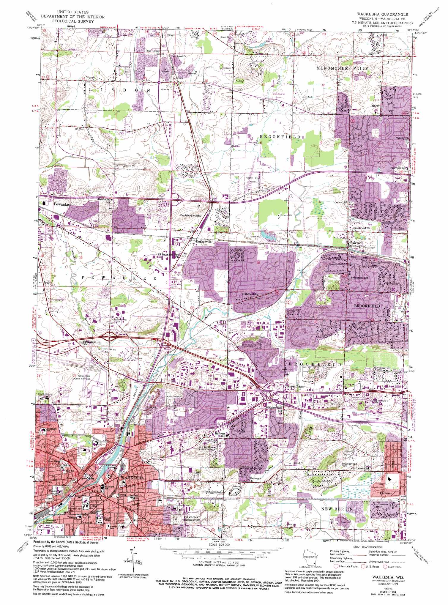
USGS Topo Quad 43088a2 - 1:24,000 scale
| Topo Map Name: | Waukesha |
| USGS Topo Quad ID: | 43088a2 |
| Print Size: | ca. 21 1/4" wide x 27" high |
| Southeast Coordinates: | 43° N latitude / 88.125° W longitude |
| Map Center Coordinates: | 43.0625° N latitude / 88.1875° W longitude |
| U.S. State: | WI |
| Filename: | o43088a2.jpg |
| Download Map JPG Image: | Waukesha topo map 1:24,000 scale |
| Map Type: | Topographic |
| Topo Series: | 7.5´ |
| Map Scale: | 1:24,000 |
| Source of Map Images: | United States Geological Survey (USGS) |
| Alternate Map Versions: |
Waukesha WI 1959, updated 1961 Download PDF Buy paper map Waukesha WI 1959, updated 1973 Download PDF Buy paper map Waukesha WI 1959, updated 1986 Download PDF Buy paper map Waukesha WI 1959, updated 1992 Download PDF Buy paper map Waukesha WI 1959, updated 1994 Download PDF Buy paper map Waukesha WI 2010 Download PDF Buy paper map Waukesha WI 2013 Download PDF Buy paper map Waukesha WI 2015 Download PDF Buy paper map |
1:24,000 Topo Quads surrounding Waukesha
Hartford West |
Hartford East |
Jackson |
Five Corners |
Cedarburg |
Stonebank |
Merton |
Sussex |
Menomonee Falls |
Thiensville |
Oconomowoc East |
Hartland |
Waukesha |
Wauwatosa |
Milwaukee |
Eagle |
Genesee |
Muskego |
Hales Corners |
Greendale |
East Troy |
Mukwonago |
Waterford |
North Cape |
Franksville |
> Back to 43088a1 at 1:100,000 scale
> Back to 43088a1 at 1:250,000 scale
> Back to U.S. Topo Maps home
Waukesha topo map: Gazetteer
Waukesha: Airports
Aero Park (historical) elevation 254m 833′Capitol Airport elevation 257m 843′
Waukesha County Airport elevation 275m 902′
Waukesha Memorial Hospital Heliport elevation 282m 925′
Waukesha: Crossings
Interchange 293C elevation 265m 869′Interchange 294 elevation 262m 859′
Interchange 295 elevation 256m 839′
Interchange 297 elevation 274m 898′
Waukesha: Dams
Saratoga Mill Dam elevation 248m 813′Waukesha: Mines
Sussex Quarry elevation 266m 872′Waukesha: Parks
Balmer Park elevation 265m 869′Banting Park elevation 268m 879′
Bethesda Spring Park elevation 244m 800′
Beverly Hills Park elevation 256m 839′
Brook Park elevation 252m 826′
Buchner Park elevation 265m 869′
Camelot Park elevation 256m 839′
Canterbury Hills Park elevation 255m 836′
Cutler Park elevation 253m 830′
Dopp Park elevation 272m 892′
Eble Park elevation 255m 836′
Fairview Park elevation 281m 921′
Fox Brook Park elevation 255m 836′
Frame Park elevation 247m 810′
Hillcrest Park elevation 298m 977′
Horeb Spring Park elevation 268m 879′
Liberty Park elevation 265m 869′
Marx Park elevation 252m 826′
McCoy Field elevation 253m 830′
Pewaukee River Parkway elevation 256m 839′
Priedeman Park elevation 274m 898′
Rolling Meadows Park elevation 255m 836′
Ruby Park elevation 253m 830′
Silurian Park elevation 253m 830′
Springdale Park elevation 256m 839′
Stoney C Halquist Park elevation 268m 879′
Wagner Park elevation 265m 869′
Weston Hills Park elevation 256m 839′
Wray Park elevation 251m 823′
Waukesha: Populated Places
Calhoun elevation 264m 866′Duplainville elevation 261m 856′
Goerkes Corner elevation 265m 869′
Marcy elevation 272m 892′
Waukesha elevation 249m 816′
Waukesha: Post Offices
Brookfield Post Office elevation 273m 895′Waukesha Post Office elevation 253m 830′
Waukesha: Reservoirs
Saratoga Lake 120 elevation 248m 813′Waukesha: Springs
Silurian Spring elevation 254m 833′Waukesha: Streams
Pewaukee River elevation 250m 820′Poplar Creek elevation 250m 820′
Waukesha digital topo map on disk
Buy this Waukesha topo map showing relief, roads, GPS coordinates and other geographical features, as a high-resolution digital map file on DVD: