Kewaskum Topo Map Wisconsin
To zoom in, hover over the map of Kewaskum
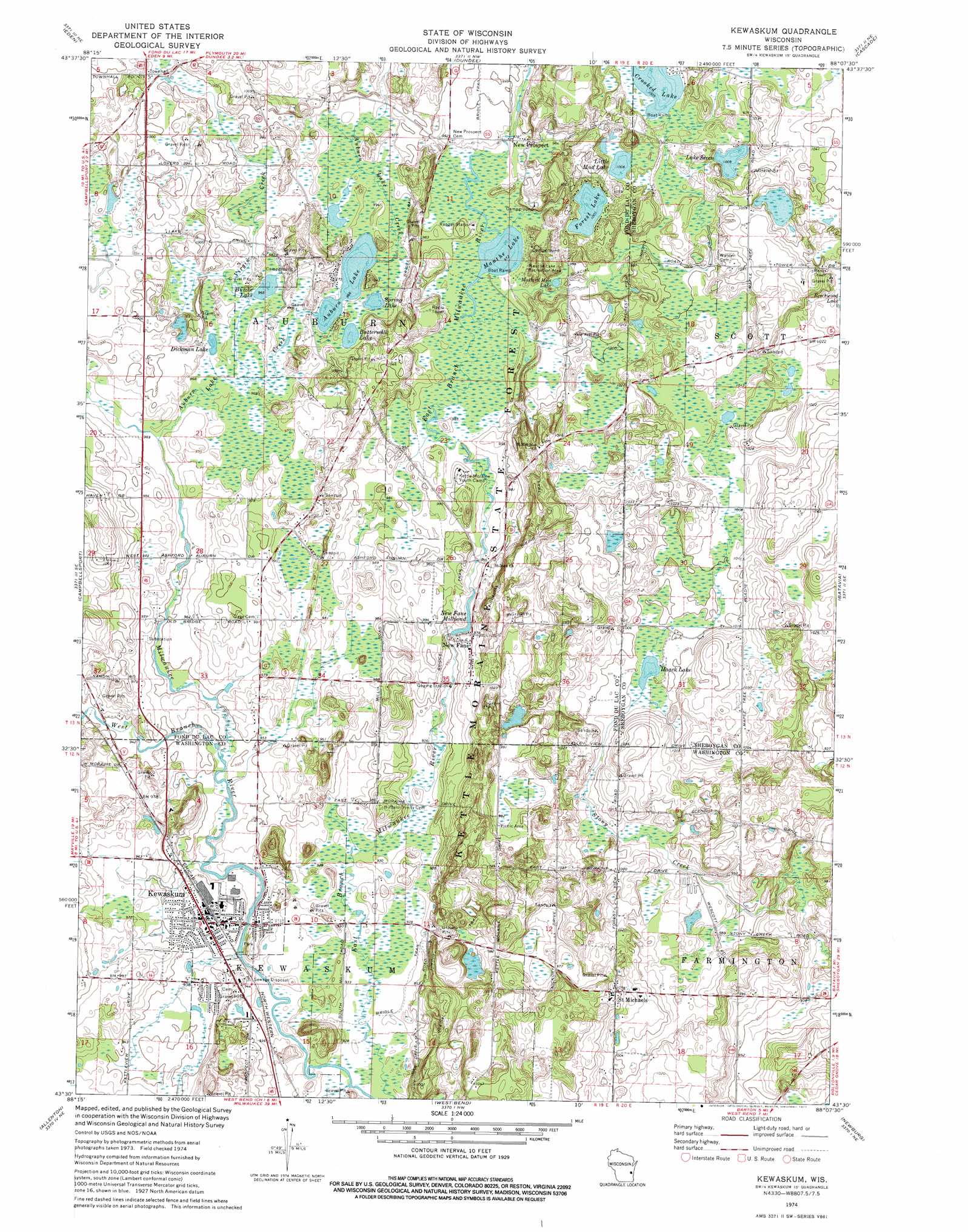
USGS Topo Quad 43088e2 - 1:24,000 scale
| Topo Map Name: | Kewaskum |
| USGS Topo Quad ID: | 43088e2 |
| Print Size: | ca. 21 1/4" wide x 27" high |
| Southeast Coordinates: | 43.5° N latitude / 88.125° W longitude |
| Map Center Coordinates: | 43.5625° N latitude / 88.1875° W longitude |
| U.S. State: | WI |
| Filename: | o43088e2.jpg |
| Download Map JPG Image: | Kewaskum topo map 1:24,000 scale |
| Map Type: | Topographic |
| Topo Series: | 7.5´ |
| Map Scale: | 1:24,000 |
| Source of Map Images: | United States Geological Survey (USGS) |
| Alternate Map Versions: |
Kewaskum WI 1974, updated 1977 Download PDF Buy paper map Kewaskum WI 1999, updated 2001 Download PDF Buy paper map Kewaskum WI 2010 Download PDF Buy paper map Kewaskum WI 2013 Download PDF Buy paper map Kewaskum WI 2015 Download PDF Buy paper map |
1:24,000 Topo Quads surrounding Kewaskum
Fond Du Lac |
Saint Peter |
Saint Cloud |
Elkhart Lake |
Franklin |
Byron |
Eden |
Dundee |
Cascade |
Plymouth South |
Lomira |
Campbellsport |
Kewaskum |
Batavia |
Random Lake |
Nenno |
Allenton |
West Bend |
Newburg |
Port Washington West |
Hartford West |
Hartford East |
Jackson |
Five Corners |
Cedarburg |
> Back to 43088e1 at 1:100,000 scale
> Back to 43088a1 at 1:250,000 scale
> Back to U.S. Topo Maps home
Kewaskum topo map: Gazetteer
Kewaskum: Lakes
Auburn Lake elevation 295m 967′Buttermilk Lake elevation 297m 974′
Butzke Lake elevation 295m 967′
Crooked Lake elevation 306m 1003′
Dickman Lake elevation 295m 967′
Forest Lake elevation 306m 1003′
Haack Lake elevation 301m 987′
Lake Seven elevation 306m 1003′
Little Mud Lake elevation 306m 1003′
Mallard Hole Lake elevation 297m 974′
Mauthe Lake elevation 297m 974′
New Fane Millpond elevation 292m 958′
Spring Lake elevation 294m 964′
Kewaskum: Parks
Haskell Noyes Memorial Woods State Natural Area elevation 326m 1069′Kettle Hole Woods State Natural Area elevation 313m 1026′
Kewaskum Kiwanis Park elevation 289m 948′
Kewaskum Maple-Oak Woods State Natural Area elevation 295m 967′
Mauthe Lake Recreation Area elevation 298m 977′
Milwaukee River and Swamp State Natural Area elevation 297m 974′
Milwaukee River Floodplain Forest State Natural Area elevation 282m 925′
River Hill Park elevation 292m 958′
Spring Lake State Natural Area elevation 296m 971′
Kewaskum: Populated Places
Kewaskum elevation 291m 954′New Fane elevation 298m 977′
New Prospect elevation 301m 987′
Saint Michaels elevation 321m 1053′
Kewaskum: Streams
Auburn Lake Creek elevation 293m 961′Virgin Creek elevation 295m 967′
West Branch Milwaukee River elevation 285m 935′
Kewaskum digital topo map on disk
Buy this Kewaskum topo map showing relief, roads, GPS coordinates and other geographical features, as a high-resolution digital map file on DVD: