Ripon Topo Map Wisconsin
To zoom in, hover over the map of Ripon
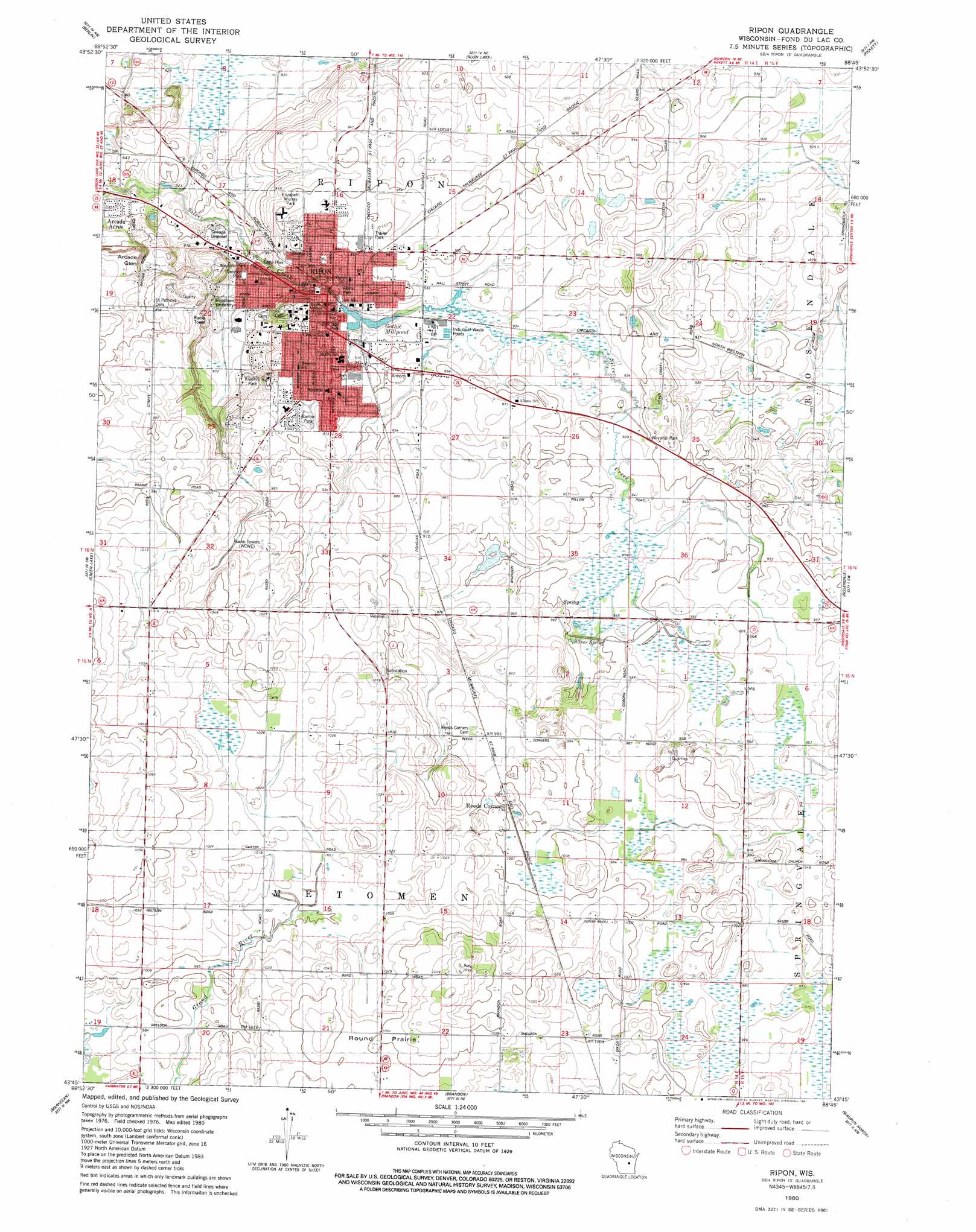
USGS Topo Quad 43088g7 - 1:24,000 scale
| Topo Map Name: | Ripon |
| USGS Topo Quad ID: | 43088g7 |
| Print Size: | ca. 21 1/4" wide x 27" high |
| Southeast Coordinates: | 43.75° N latitude / 88.75° W longitude |
| Map Center Coordinates: | 43.8125° N latitude / 88.8125° W longitude |
| U.S. State: | WI |
| Filename: | o43088g7.jpg |
| Download Map JPG Image: | Ripon topo map 1:24,000 scale |
| Map Type: | Topographic |
| Topo Series: | 7.5´ |
| Map Scale: | 1:24,000 |
| Source of Map Images: | United States Geological Survey (USGS) |
| Alternate Map Versions: |
Ripon WI 1980, updated 1981 Download PDF Buy paper map Ripon WI 2010 Download PDF Buy paper map Ripon WI 2013 Download PDF Buy paper map Ripon WI 2015 Download PDF Buy paper map |
1:24,000 Topo Quads surrounding Ripon
Redgranite |
Auroraville |
Eureka |
Omro |
Oshkosh |
Fairburn |
Berlin |
Rush Lake |
Pickett |
Van Dyne |
Princeton East |
Green Lake |
Ripon |
Rosendale |
Eldorado |
Manchester |
Markesan |
Brandon |
Waupun North |
Oakfield |
Randolph |
Fox Lake |
Buckhorn Corner |
Waupun South |
Mayville North |
> Back to 43088e1 at 1:100,000 scale
> Back to 43088a1 at 1:250,000 scale
> Back to U.S. Topo Maps home
Ripon topo map: Gazetteer
Ripon: Dams
Ripon Dam elevation 281m 921′Ripon: Flats
Round Prairie elevation 320m 1049′Ripon: Parks
Ashley Courts elevation 285m 935′Atkins Park elevation 283m 928′
Barlow Park elevation 298m 977′
Ceresco Park elevation 265m 869′
Eagle Park elevation 277m 908′
Elizabeth Murray Park elevation 292m 958′
Ingalls Field elevation 286m 938′
Kiwanis Park elevation 278m 912′
Ripon College Historic District elevation 296m 971′
Ripon Prairie State Natural Area elevation 293m 961′
Sadoff Fields elevation 271m 889′
Selfridge Park elevation 281m 921′
Ripon: Populated Places
Arcade Acres elevation 247m 810′Ripon elevation 284m 931′
Ripon: Post Offices
Ripon Post Office elevation 283m 928′Ripon: Reservoirs
Gothic Millpond elevation 279m 915′Ripon Pond 23.3 elevation 281m 921′
Ripon: Springs
Silver Spring elevation 286m 938′Ripon: Summits
Scott Hill elevation 311m 1020′Ripon: Valleys
Arcade Glen elevation 272m 892′Ripon: Woods
Bowens Woods elevation 284m 931′Ripon digital topo map on disk
Buy this Ripon topo map showing relief, roads, GPS coordinates and other geographical features, as a high-resolution digital map file on DVD: