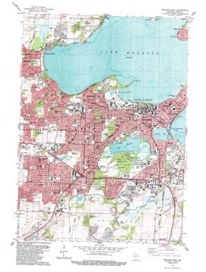
Madison West Topo Map Wisconsin
To zoom in, hover over the map of Madison West
USGS Topo Quad 43089a4 - 1:24,000 scale
| Topo Map Name: | Madison West |
| USGS Topo Quad ID: | 43089a4 |
| Print Size: | ca. 21 1/4" wide x 27" high |
| Southeast Coordinates: | 43° N latitude / 89.375° W longitude |
| Map Center Coordinates: | 43.0625° N latitude / 89.4375° W longitude |
| U.S. State: | WI |
| Filename: | o43089a4.jpg |
| Download Map JPG Image: | Madison West topo map 1:24,000 scale |
| Map Type: | Topographic |
| Topo Series: | 7.5´ |
| Map Scale: | 1:24,000 |
| Source of Map Images: | United States Geological Survey (USGS) |
| Alternate Map Versions: |
Madison West WI 1959, updated 1960 Download PDF Buy paper map Madison West WI 1959, updated 1970 Download PDF Buy paper map Madison West WI 1959, updated 1975 Download PDF Buy paper map Madison West WI 1959, updated 1979 Download PDF Buy paper map Madison West WI 1983, updated 1984 Download PDF Buy paper map Madison West WI 2010 Download PDF Buy paper map Madison West WI 2013 Download PDF Buy paper map Madison West WI 2016 Download PDF Buy paper map |
1:24,000 Topo Quads surrounding Madison West
> Back to 43089a1 at 1:100,000 scale
> Back to 43088a1 at 1:250,000 scale
> Back to U.S. Topo Maps home
Madison West topo map: Gazetteer
Madison West: Airports
Meriter-Madison General Hospital Heliport elevation 265m 869′Saint Marys Hospital Medical Center Heliport elevation 260m 853′
University of Wisconsin Hospital and Clinics Heliport elevation 276m 905′
Madison West: Bays
Brittingham Bay elevation 257m 843′Monona Bay elevation 257m 843′
University Bay elevation 259m 849′
Madison West: Capes
Picnic Point elevation 259m 849′Second Point elevation 259m 849′
Madison West: Cliffs
Fox Bluff elevation 280m 918′Maple Bluff elevation 273m 895′
Madison West: Dams
Lake Wingra WP 74 Dam elevation 260m 853′Madison West: Islands
Governors Island elevation 259m 849′Madison West: Lakes
Goose Lake elevation 290m 951′Lake Mendota elevation 259m 849′
Lake Wingra elevation 258m 846′
Madison West: Parks
Baskerville Park elevation 274m 898′Belmare Park elevation 309m 1013′
Bordner Park elevation 274m 898′
Boundary Park elevation 297m 974′
Bowman Park elevation 259m 849′
Britta Park elevation 307m 1007′
Brittingham Park elevation 257m 843′
Camp Randall Stadium elevation 267m 875′
Capitol Square elevation 281m 921′
Devolis Park elevation 308m 1010′
Dunns Marsh Park elevation 299m 980′
Edward Klief Park elevation 261m 856′
Elizabeth Link Peace Park elevation 267m 875′
Garner Park elevation 317m 1040′
Gidding Park elevation 263m 862′
Green Oak Hills Park elevation 284m 931′
Henry Mall elevation 270m 885′
Henry Vilas Park elevation 261m 856′
Hiawatha Circle Park elevation 297m 974′
Hillington Triange elevation 276m 905′
Hoyt Park elevation 298m 977′
Indian Hills Park elevation 277m 908′
James Madison Park elevation 260m 853′
Kettle Pond Park elevation 277m 908′
Lakeview Community Park elevation 262m 859′
Law Park elevation 258m 846′
Library Mall elevation 262m 859′
Lucia Crest Park elevation 271m 889′
Marshall Park elevation 267m 875′
McClimon Track elevation 263m 862′
Meadow Park elevation 287m 941′
Meadowood Park elevation 314m 1030′
Mendota Park elevation 262m 859′
Mineral Point Park elevation 312m 1023′
Nielsen Tennis Stadium elevation 259m 849′
Olin Park elevation 267m 875′
Orchid Heights Park elevation 267m 875′
Owen Park elevation 302m 990′
Parisi Park elevation 281m 921′
Penn Park elevation 271m 889′
Period Garden Park elevation 272m 892′
Quann Park elevation 262m 859′
Reservoir Park elevation 324m 1062′
Robin Park elevation 287m 941′
Segoe Park elevation 300m 984′
Slayter Park elevation 302m 990′
Spring Harbor Park elevation 261m 856′
Stonefield Park elevation 289m 948′
Sundridge Park elevation 309m 1013′
Sunset Park elevation 305m 1000′
University Hills Park elevation 283m 928′
Vilas Circle elevation 274m 898′
Western Hills Park elevation 316m 1036′
Westmorland Park elevation 292m 958′
Wingra Park elevation 261m 856′
Madison West: Populated Places
Bowens Addition elevation 261m 856′College Hills elevation 278m 912′
Greenbush Addition elevation 265m 869′
Madison elevation 267m 875′
Madison Mobile Home Park elevation 298m 977′
Maple Bluff elevation 267m 875′
Mendota Beach elevation 264m 866′
Oakland Heights elevation 262m 859′
Pheasant Branch elevation 261m 856′
Pilgrim Village elevation 314m 1030′
Preglers Addition elevation 259m 849′
Shorewood Hills elevation 271m 889′
South Madison elevation 261m 856′
Syene (historical) elevation 274m 898′
Warrens Addition elevation 260m 853′
Wingra Park elevation 275m 902′
Madison West: Post Offices
Robert M La Follette Senior Post Office Building elevation 277m 908′Madison West: Reservoirs
Lake Wingra 6 elevation 260m 853′Madison West: Streams
Pheasant Branch elevation 259m 849′Wingra Creek elevation 258m 846′
Madison West: Summits
Bascom Hill elevation 290m 951′Eagle Heights elevation 308m 1010′
Mansion Hill elevation 283m 928′
Observatory Hill elevation 290m 951′
Madison West: Swamps
Great Central Marsh (historical) elevation 261m 856′Madison West digital topo map on disk
Buy this Madison West topo map showing relief, roads, GPS coordinates and other geographical features, as a high-resolution digital map file on DVD:


