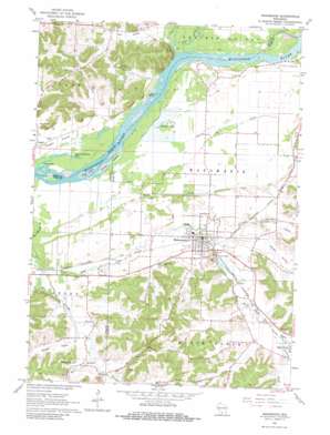
Mazomanie Topo Map Wisconsin
To zoom in, hover over the map of Mazomanie
USGS Topo Quad 43089b7 - 1:24,000 scale
| Topo Map Name: | Mazomanie |
| USGS Topo Quad ID: | 43089b7 |
| Print Size: | ca. 21 1/4" wide x 27" high |
| Southeast Coordinates: | 43.125° N latitude / 89.75° W longitude |
| Map Center Coordinates: | 43.1875° N latitude / 89.8125° W longitude |
| U.S. State: | WI |
| Filename: | o43089b7.jpg |
| Download Map JPG Image: | Mazomanie topo map 1:24,000 scale |
| Map Type: | Topographic |
| Topo Series: | 7.5´ |
| Map Scale: | 1:24,000 |
| Source of Map Images: | United States Geological Survey (USGS) |
| Alternate Map Versions: |
Mazomanie WI 1962, updated 1964 Download PDF Buy paper map Mazomanie WI 1962, updated 1967 Download PDF Buy paper map Mazomanie WI 1962, updated 1981 Download PDF Buy paper map Mazomanie WI 2010 Download PDF Buy paper map Mazomanie WI 2013 Download PDF Buy paper map Mazomanie WI 2016 Download PDF Buy paper map |
1:24,000 Topo Quads surrounding Mazomanie
> Back to 43089a1 at 1:100,000 scale
> Back to 43088a1 at 1:250,000 scale
> Back to U.S. Topo Maps home
Mazomanie topo map: Gazetteer
Mazomanie: Canals
Big Ditch elevation 226m 741′Mazomanie: Cliffs
Ferry Bluff elevation 323m 1059′Mazomanie: Dams
Mazomanie 2WP881 Dam elevation 237m 777′Mazomanie: Flats
Cassell Prairie elevation 225m 738′Mazomanie: Islands
Grape Island elevation 225m 738′Otter Island elevation 225m 738′
Twin Islands elevation 225m 738′
Mazomanie: Lakes
Deacon Thomas Lake elevation 225m 738′Fishers Lake elevation 225m 738′
Long Lake elevation 225m 738′
Mazomanie: Parks
Black Earth Rettenmund Prairie State Natural Area elevation 257m 843′Ferry Bluff State Natural Area elevation 330m 1082′
Mazomanie Bottoms State Natural Area elevation 225m 738′
Mazomanie: Populated Places
Mazomanie elevation 234m 767′Mazomanie: Reservoirs
Lake Marion Pond elevation 237m 777′Mazomanie: Streams
Black Earth Creek elevation 225m 738′Dunlap Creek elevation 225m 738′
East Branch Blue Mounds Creek elevation 229m 751′
Halfway Prairie Creek elevation 233m 764′
Honey Creek elevation 225m 738′
Marsh Creek elevation 225m 738′
Otter Creek elevation 221m 725′
Vermont Creek elevation 247m 810′
West Branch Blue Mounds Creek elevation 228m 748′
Mazomanie: Summits
Twin Bluffs elevation 291m 954′Mazomanie: Valleys
Dunlap Hollow elevation 231m 757′Fair Valley elevation 226m 741′
Knight Valley elevation 234m 767′
Marsh Valley elevation 238m 780′
Mazomanie digital topo map on disk
Buy this Mazomanie topo map showing relief, roads, GPS coordinates and other geographical features, as a high-resolution digital map file on DVD:


