Lodi Topo Map Wisconsin
To zoom in, hover over the map of Lodi
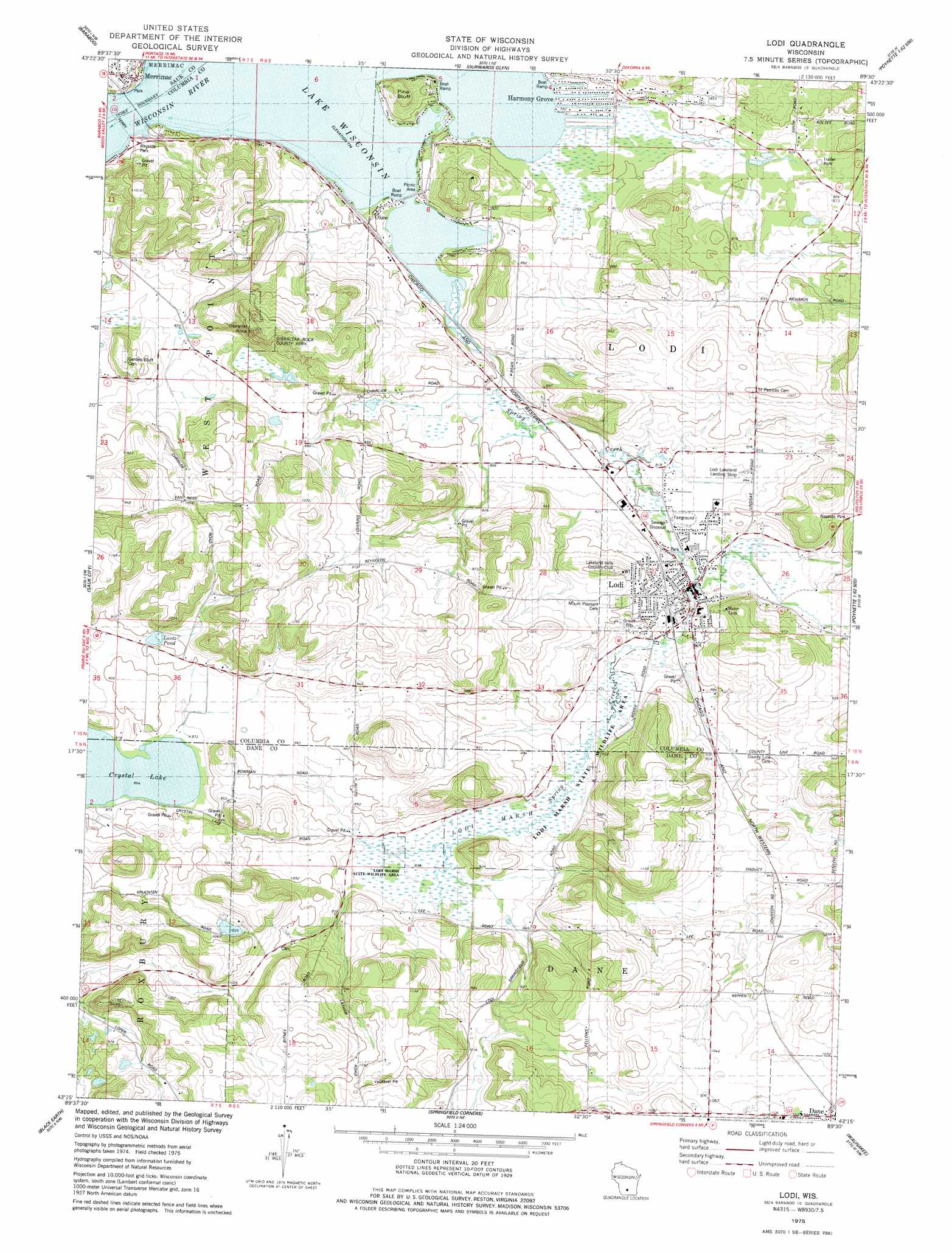
USGS Topo Quad 43089c5 - 1:24,000 scale
| Topo Map Name: | Lodi |
| USGS Topo Quad ID: | 43089c5 |
| Print Size: | ca. 21 1/4" wide x 27" high |
| Southeast Coordinates: | 43.25° N latitude / 89.5° W longitude |
| Map Center Coordinates: | 43.3125° N latitude / 89.5625° W longitude |
| U.S. State: | WI |
| Filename: | o43089c5.jpg |
| Download Map JPG Image: | Lodi topo map 1:24,000 scale |
| Map Type: | Topographic |
| Topo Series: | 7.5´ |
| Map Scale: | 1:24,000 |
| Source of Map Images: | United States Geological Survey (USGS) |
| Alternate Map Versions: |
Baraboo SE WI 1974, updated 1976 Download PDF Buy paper map Lodi WI 1975, updated 1978 Download PDF Buy paper map Lodi WI 2010 Download PDF Buy paper map Lodi WI 2013 Download PDF Buy paper map Lodi WI 2016 Download PDF Buy paper map |
1:24,000 Topo Quads surrounding Lodi
Wisconsin Dells South |
Lewiston |
Pine Island |
Portage |
Pardeeville |
North Freedom |
Baraboo |
Durwards Glen |
Poynette |
Wyocena |
Sauk Prairie |
Sauk City |
Lodi |
Arlington |
Morrisonville |
Mazomanie |
Black Earth |
Springfield Corners |
Waunakee |
De Forest |
Blue Mounds |
Cross Plains |
Middleton |
Madison West |
Madison East |
> Back to 43089a1 at 1:100,000 scale
> Back to 43088a1 at 1:250,000 scale
> Back to U.S. Topo Maps home
Lodi topo map: Gazetteer
Lodi: Airports
Lodi Lakeland Airport elevation 276m 905′Lodi: Cliffs
Pine Bluff elevation 269m 882′Lodi: Crossings
Merrimac Ferry elevation 236m 774′Lodi: Lakes
Crystal Lake elevation 263m 862′Lantz Pond elevation 273m 895′
Lodi: Parks
Gibraltar Rock County Park elevation 363m 1190′Gibraltar Rock State Natural Area elevation 355m 1164′
Lodi Marsh State Natural Area elevation 256m 839′
Lodi Marsh State Wildlife Area elevation 255m 836′
Lodi: Pillars
Gibraltar Rock elevation 380m 1246′Lodi: Populated Places
Dane elevation 328m 1076′Harmony Grove elevation 238m 780′
Lake Wisconsin elevation 247m 810′
Lodi elevation 250m 820′
Merrimac elevation 254m 833′
Okee elevation 244m 800′
Lodi: Streams
Spring Creek elevation 236m 774′Lodi: Swamps
Lodi Marsh elevation 256m 839′Lodi digital topo map on disk
Buy this Lodi topo map showing relief, roads, GPS coordinates and other geographical features, as a high-resolution digital map file on DVD: